
Area 20,723 km² University Akdeniz University | Vehicle registration 07 Population 2.288 million (2015) Area code 242 | |
 | ||
Points of interest Destinations | ||
Antalya Province (Turkish: Antalya ili) is located on the Mediterranean coast of south-west Turkey, between the Taurus Mountains and the Mediterranean sea.
Contents
- Map of Antalya Turkey
- Etymology
- Antiquity
- The Byzantines
- The Seljuk Turks
- The Ottoman Empire onwards
- Districts and cities
- Geography
- Demographics
- Education
- Media and broadcasting
- Places of interest
- Ancient cities and ruins
- National parks
- Sites of natural beauty
- Caves
- References
Map of Antalya, Turkey
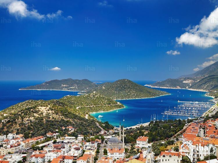
Antalya Province is the centre of Turkey's tourism industry, attracting 30% of foreign tourists visiting Turkey. It was the world's third most visited city by number of international arrivals in 2011, displacing New York. Antalya is Turkey's biggest international sea resort. The province of Antalya corresponds to the lands of ancient Pamphylia to the east and Lycia to the west. It features a shoreline of 657 km (408 mi) with beaches, ports, and ancient cities scattered throughout, including the World Heritage Site Xanthos. The provincial capital is Antalya city with a population of 1,001,318.
Antalya is the fastest-growing province in Turkey; with a 4.17% yearly population growth rate between years 1990–2000, compared with the national rate of 1.83%. This growth is due to a fast rate of urbanization, particularly driven by tourism and other service sectors on the coast.
Etymology
The city and thus the province are named after Attalos II, king of Pergamon, who founded the city in the 2nd century BC.
Antiquity
Antalya has been settled since pre-historic times. Evidence of human habitation dating back to the early Paleolithic age (150,000-200,000) years has been discovered in the Karain cave, 30 km (19 mi) of the north of Antalya city. Other finds dating back to the Mesolithic (Beldibi Cave), Neolithic (Bademağacı Höyüğü) and more recent periods show that the area has been populated by various civilizations throughout the ages.
There are long periods shrouded in mystery until records from the Hittite period refer to the area as part of the "Lukka Lands" (from which "Lycia" is derived) and document the lively interaction going on between provinces in the second millennium BC. Like their descendants, the Lukkans or Lycians were known for their seamanship (especially their piracy) and demonstrated a fiery independent spirit. Neither the Hittites, nor the Kingdom of Arzawa on the west coast, could ever keep them at peace for long. Legends of Ancient Greece tell us that these communities grew into independent cities, the area as a whole came to be called Pamphylia. A federation of these cities was set up. There are also tales of the migration of the Akha clan to the area after the Trojan war and eventually Greek settlements were built along the coast and inland.
In the Hellenistic period, the western parts of Antalya province were in Lycia, the east was in Pamphylia, and at the extremes east, in ancient Cilicia, while Pisidia was to the north.
Before the Ancient Roman conquest Lycia was a polity with the first democratic constitution in the world, which later partly inspired the American Constitution.
Antalya was part of the Lydian kingdom from the 7th century BC until Lydia was defeated by the Persians during the battle of Sardis in 546 BC. The Macedonian commander Alexander the Great ended Persian rule and in around 334 BC conquered the cities of the area one by one—except for Termessos and Sillyon which managed to repulse his armies in 333 BC. After the death of Alexander in 323 BC, a long battle erupted between his generals that lasted until 188 BC.
The reign of the kingdom of Pergamon began with the defeat of the Seleucid army at Apamea. Shortly after this the city of Antalya was founded. When Attalos III, the last king of Pergamom, died in 133 BC he left his kingdom to the Ancient Romans. At this time the area is dominated by pirates based in small cities along the coast.
The Byzantines
During the mid-Byzantine era (the 5th and 6th centuries) the city of Antalya grew beyond the city walls.
From the 7th century Muslim Arabs started to be dominant in the Levant region and Antalya later played a part in the Christian Crusades against Islam. The army of Louis VII sailed from Antalya for Syria in 1148, and the fleet of Richard I of England rallied here before the conquest of Cyprus. In the late 11th and early 12th Century much of the area of the modern province fell to the Turks especially the Danishmends. From 1120 to March 1207, Antalya was again under the sovereignty of Byzantines.
The Seljuk Turks
The area was conquered by the Seljuk Turks and recaptured by the Byzantines again and again from 1076 onwards as the Seljuks strove to establish a trading base on the Mediterranean. At one stage Turkish lord Kilij Arslan had a palace here. In 1220 Byzantine rule ended for the last time and the city was quickly divided into Christian and Muslim sections, the Christian trading communities including Venetians and Genoese. Alanya also grew and throve during the Seljuk period.
The Ottoman Empire onwards
The area passed through many hands before its final occupation by the Ottoman Empire under Murad II in 1432. Antalya also was occupied by Kingdom of Cyprus between 1361 and 1373. Ottoman rule of the coast persisted until the end of the First World War, when Antalya was briefly occupied by Italian troops before becoming part of the Republic of Turkey in 1921.
There are many archaeological sites in the province including three National Parks and three Specially Protected Areas.
Districts and cities
Geography
Antalya province is situated in south-west Anatolia, between the longitudes 29°20'-32°35'East and latitudes 36°07'-37°29'North. The province covers an area of %26 (20591 sq m) of Turkey. The southern border of the province is the Mediterranean sea while the Taurus mountains draw the land border. From west to east the province is bordered by Muğla, Burdur, Isparta, Konya and İçel provinces. The land of the province is 77.8% mountainous, 10.2% plain and 12% uneven. Many of the peaks of the Taurus mountains are above 500–3000 metres. The Teke peninsula (corresponds to ancient Lycia) in the west includes wide plateaus and river basins. Climate, agriculture, demographics and habitation patterns differ greatly between the inland mountain areas and the coastal plain.
Demographics
The population of Antalya province is 1.978.333. Antalya is the fifth province of Turkey with high foreigner resident population which is 6,343. [need a table with yrs VS population]
Education
The city of Antalya has 1 public university (Akdeniz University) and 1 private university (Antalya International University). Antalya's public education system is run by the Turkish National School Board (TNSB) (Turkish: Milli Eğitim Bakanlığı (MEB))
Media and broadcasting
Antalya has a broad variety of local media such as radio channels and newspapers. Local television networks Akdeniz TV and Kanal V are aired nationally in Turkey by Turksat 4A satellite.
Places of interest
The highest point of the Taurus mountains is Akdağ at an altitude of 3025 metres. Located to the northwest of the city centre and at a distance of 50 km (31 mi) is the Saklıkent ski and recreation centre on Beydağları. Here one can ski and then go down to the shore and into the sea during the months of January–April. In Saklıkent there are two teleski and ski courses along with villas and accommodation facilities available in the area. Situated on Bakırlı Hill behind Saklıkent is the Antalya National Space Observatory. It is possible to watch meteor showers and shooting stars on certain days of the year. In rivers rafting and canoeing sports and on the Taurus mountains jeep safari, hunting and trekking tours are organised. Alternatively, there is rock-climbing, bird watching tourism, photo-safari, mountain tourism, line fishing and health tourism at the thalasso and dialysis centres in Geyikbayırı. Holy tourism activities are organized in Myra and Patara where St Nicholas was born and lived. The eternal flames of Chimaera that was the inspiration for the Chimera myth is also located in Antalya. In the area of Belek, 30 km (19 mi). east of Antalya, there is a big potential for golf tourism with the bonus of the cultural, historical and natural sightseeing of the region. There are five golf facilities already operating in Belek. There are underwater diving centres on the coast, primarily in Kemer, Çamyuva, Olympos, Adrasan, Kaş, Kalkan, Üçağız, Kekova, Side and Alanya. In addition, yacht tours are organized from the port of Antalya to Düden Waterfall-Karpuzkaldıran and Kemer, from Side to Alanya, from Demre-Çayağzı to Kekova, from Kaş to Kekova, from Kemer to Çıralı-Olympos-Adrasan and Cape Gelidonya. There are also boat tours on Manavgat creek and canoe tours on Xanthos creek. In addition, Blue Cruise, which covers the southwestern Anatolian coast, ends in Antalya. There are ferryboat trips from Alanya to Cyprus and from Antalya to Italy. Antalya today is a world tourism centre with its unique touristic accommodation facilities, nature and historical beauties.
Ancient cities and ruins
There are sites of historical and archaeological interest all over Antalya including
National parks
Sites of natural beauty
Caves
There are more than twenty caves in Antalya Province, among them some are show caves and registered natural monuments.