
Formed 7 June 2014 Highest gust 144 km/h (89 mph). Dates 7 Jun 2014 – 11 Jun 2014 | Dissipated 11 June 2014 Areas affected Western Europe Location Western Europe | |
 | ||
Type Spanish plumeconvective stormMesoscale convective systemBow Echo | ||
2014 Pentecost weekend storms in Europe were a series of severe supercell storms affecting western Europe which followed a heatwave in early June 2014, resulting from a Spanish plume synoptic weather pattern. The weekend saw repeated convective storm development across an arc from southwest France towards Paris and on towards Belgium and northwest Germany, where warm air masses interacted with the cooler air brought in by an area of low pressure moving towards the continent from the Atlantic. Outbreaks of severe weather were reported from these storm developments with the worst damages occurring over the German state of North Rhine-Westphalia on 9 June, where the storm was described as one of the most violent in decades by the German weather service (Deutscher Wetterdienst), this storm is also referred to as low pressure area "Ela" in some German media.
Contents
Synoptic situation
The synoptic conditions of a Spanish plume or as described in German as an "antizyklonale Südlage" saw a low pressure area named Ela (by the Free University of Berlin) over the eastern Atlantic, and high pressure (named Wolfgang) over Central Europe which brought a flow of warm air originating from the north west African Maghreb to eastern France and Germany. This airmass from Morocco and Sahara, saw temperatures reach up to 38 °C on Whit Monday.
Heatwave
Over the weekend before Pentecost temperatures reached a new level for the first ten days of June and monthly records were broken in some areas of eastern France and southwestern Germany.
France
Across France the temperature widely exceeded 30 °C, reaching over 35 °C in the areas of the Massif Central and the south and east of the country. The warmest regions were predicted to occur in the area from Lyon to Alsace. With the French regions from the Pyrenees to the Paris Basin and on to Belgium seeing high temperatures, while warm air moved into the east of France and into Germany from the south. Marisol Touraine, the French Minister of Social Affairs and Health activated the public information system in response to the heatwave.
Switzerland
Switzerland saw high temperatures though not extreme or record breaking, temperatures were 30-34 °C in the Rhine valley and Valais. Pilatus mountain above Lucerne witnessed a concentration in Saharan dust carried over in the air mass. 9 June equalled the maximum recorded temperature in Sion at 36.2 °C, the Swiss lowlands saw a high temperature of 35.5 °C recorded in Basel.
Germany
The warm airmass approached Germany from south-east along the Rhône valley and through the Belfort Gap, first in to the Upper Rhine Graben which saw especially warm temperatures. Another area of heat was focused in the Lower Franconian "heat island", where also temperatures of more than 37 degrees Celsius were measured.
Severe weather
In passing thunderstorm cells, violent gusts of wind were recorded. On Monday 9 June a 130 kilometres per hour (81 mph) gust was recorded in Cognac, Charente. This is the fourth highest gust since 1981 and the highest since the passage of Cyclone Lothar and Martin in December 1999, when a 158 kilometres per hour (98 mph) gust was measured. At Melle, Deux-Sèvres in western France, the wind blew the same day at 120 kilometres per hour (75 mph) this is the second highest gust recorded since the opening of the station after that observed during the passage of Cyclone Lothar and Martin in December 1999. The day before (8 June), in Magnanville, Yvelines department there had been gust of 106 kilometres per hour (66 mph) measured in the evening and a 110 kilometres per hour (68 mph) gust at Pontoise, in the northwestern suburbs of Paris.
Between Saturday 7 and Tuesday 10 June morning, there fell in total 55mm of rain Saint-Sauveur-Marville Marville (Eure-et-Loir), which corresponds to 5–6 weeks worth of rainfall during an average June in Paris. Huge hailstones some 5 to 10 cm in diameter, were also observed 9 June in the Loiret department of north central France, and the night of Monday to Tuesday in the east of the Île-de-France.
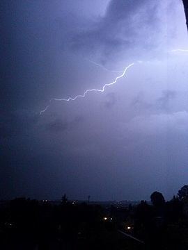
The total number of lightning discharges on 9 June was more than 64,000 in the Netherlands, such a number is on average only seen once per summer season. Wind gusts at the KNMI station Beek (Maastricht airport) reached 19 metres per second (68 km/h) during the overhangs of the storm complex. In Eindhoven and Volkel winds of 22 metres per second (79 km/h) were recorded. Over the border in Germany saw some very intense gusts, in Düsseldorf a gust of 144 kilometres per hour (89 mph) was observed at the airport. Earlier in the day during a thunderstorm in Zeeland, Netherlands a 23 metres per second (83 km/h) gust measured at the Tholen measuring station. The Supercell thunderstorm produced an estimated 113,708 lightning strikes across Germany between 2pm 9 June and 8am 10 June.
The North Rhine Westphalian city of Neuss saw a top windspeed of 133 kilometres per hour (83 mph) and in the Ruhr city of Castrop-Rauxel a wind of 124 kilometres per hour (77 mph) was reported during the passage of the storm. In the area around 40 liters of rainfall per square meter fell.