
Max rating Damage 2.4 billion USD | Highest winds 190 mph (310 km/h) Number of casualties 64 | |
 | ||
Similar 2011 Super Outbreak, 1974 Super Outbreak, 2011 Joplin tornado, 2013 Moore Tornado, 2005 Birmingham tornado | ||
The 2011 Tuscaloosa–Birmingham tornado was a large and violent EF4 multiple-vortex tornado that devastated portions of Tuscaloosa and Birmingham, Alabama, as well as smaller communities and rural areas between the two cities, during the late afternoon and early evening of Wednesday, April 27, 2011. It is one of the costliest tornadoes on record. It was one of the 362 tornadoes in the 2011 Super Outbreak, the largest tornado outbreak in United States history. The tornado reached a maximum path width of 1.5 mi (2.4 km) during its track through Tuscaloosa, and once again when it crossed Interstate 65 north of Birmingham, and attained estimated winds of 190 mph (310 km/h) shortly after passing through the city. It then went on to impact parts of Birmingham as a high-end EF4 before dissipating. This was the third tornado to strike the city of Tuscaloosa in the past decade, and the second in two weeks.
Contents
Meteorological synopsis
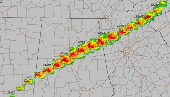
On April 23, the Storm Prediction Center (SPC) began monitoring the potential for a substantial severe weather outbreak in the extended range. As a shortwave trough tracked across portions of the Mid-South and southeastern United States, moderate instability and strong wind shear ahead of a trailing cold front was expected to promote the development of supercell thunderstorms capable of producing tornadoes, large hail, and damaging winds. Two days before the event, on April 25, the SPC issued a moderate risk of severe weather encompassing portions of central and eastern Kentucky, middle and eastern Tennessee, northeast Mississippi, central and northern Alabama, and northwest Georgia. Due to the combination of rich low-level moisture, strong shear, and focused large-scale ascent, there was relatively high confidence across the outlined area for strong tornadoes – a tornado rated EF2 or higher on the Enhanced Fujita scale – and widespread damaging winds. By the morning of April 27, the SPC upgraded to a high risk of severe weather, noting that a dangerous tornado outbreak capable of producing several violent – an EF4 tornado or stronger on the Enhanced Fujita scale – and long-track tornadoes was expected.
Shortly before noon CDT, the probability of tornadoes within 25 miles of a location was increased even further to 45%, a level exceeding even typical high risk standards, for an area including Tuscaloosa. The forecast continued to emphasize the risk of strong/violent and very damaging tornadoes, as confidence increased even further regarding the risk for an extreme, high-end tornado outbreak. Throughout the afternoon hours, in the wake of an earlier mesoscale convective system, the airmass across western and northern portions of Alabama began to quickly destabilize, with mixed layer Convective available potential energy (CAPE) estimated in the 2500–4000 j/kg range and low-level dewpoints of 70–72 °F surging northward from Louisiana. Meanwhile, the wind shear environment became substantially more favorable as an 80–100 kt mid-level jet ejected eastward into the region. At 1:45 p.m. CDT (1845 UTC), a Particularly Dangerous Situation (PDS) tornado watch was issued for much of Alabama, northwest Georgia, southeast Mississippi, and southern middle Tennessee, with a >95% probability of at least two tornadoes and one or more strong tornadoes. Shortly thereafter, at 3:09 p.m. CDT (2009 UTC), the National Weather Service office in Jackson, Mississippi issued the first tornado warning on the supercell that would eventually produce the Tuscaloosa–Birmingham tornado.
Tornado summary
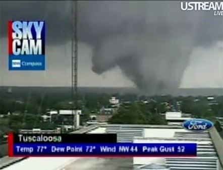
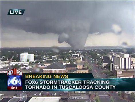
The supercell produced a large wedge tornado in rural Greene County, Alabama, which tracked towards the neighboring Tuscaloosa County, uprooting numerous trees. Near Union at 4:50 p.m. CDT, the tornado was captured live on ABC 33/40 by meteorologist John Oldshue. This was the first video evidence that the tornado was on the ground, and a tornado emergency was declared. Rapidly intensifying, the tornado moved towards the southern and eastern portions of Tuscaloosa at around 5:10 p.m. CDT (2210 UTC). Skycams operated by Tuscaloosa television station WVUA-CA (channel 7) as well as Birmingham Fox affiliate WBRC (channel 6), ABC affiliate WBMA-LD/WCFT-TV/WJSU-TV (channels 58, 33, and 40), and CBS affiliate WIAT (channel 42) captured video of the tornado as it struck Tuscaloosa (WIAT took home multiple awards, including a regional Edward R. Murrow Award for "Outstanding Live Coverage" during the event).
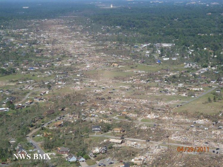
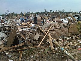
The tornado entered the south side of Tuscaloosa as a high-end EF4 and crossed 35th Street, completely destroying a cell phone tower and several warehouses in an industrial area. It then ripped through the neighborhoods of Rosedale and Forest Lake, leveling and sweeping away numerous poorly-anchored homes. Apartment complexes were entirely destroyed in this area, including a few two-story apartment buildings that were completely reduced to rubble. The tornado crossed the intersection of 15th Street and McFarland Boulevard, and numerous businesses and restaurants near the University Mall were completely flattened at high-end EF4 strength, and multiple vehicles were tossed around or destroyed. The nearby Cedar Crest subdivision was devastated as numerous block-foundation homes were leveled. The tornado maintained its strength as it continued through the eastern Tuscaloosa neighborhood of Alberta City, leveling and sweeping away numerous block-foundation homes, and completely flattening two more apartment buildings and a shopping center along University Boulevard. As the tornado exited Alberta City, the Chastain Manor Apartments (which were nailed, rather than bolted to their foundations) were completely destroyed and partially swept away. A well-anchored clubhouse on the property was mostly swept away and its remains were scattered into a pond, even though the structure lacked interior walls. A nearby manhole cover was removed from its drain and thrown into a ravine.
The tornado then ripped though the eastern Tuscaloosa suburb of Holt, leveling or sweeping away multiple homes still at high-end EF4 strength. Every tree in its direct path was snapped in this area, including within deep ravines. As the tornado crossed Hurricane Creek, it tore apart a large metal railroad trestle, and a 34-tonne (74,957 lb) metal truss support structure was thrown 100 ft (30 m) up a nearby hill. A marina on Holt Lake was significantly impacted, with numerous boats and a restaurant destroyed; some boats were tossed over 100 meters in this area. The tornado exited the Tuscaloosa area and continued through dense forest towards Birmingham, this time downing thousands of trees and flattening more rural homes. Numerous trees were completely denuded and debarked as the tornado passed near the rural communities of Searles and Mud Creek, and debris from Tuscaloosa was reported to be falling from the sky across Birmingham over 20 miles (32 km) away in Jefferson County. A total of 44 people were killed in the Tuscaloosa area.
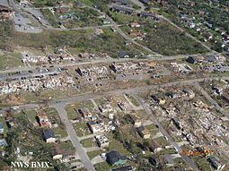
After causing massive timber damage in rural areas, the tornado, now becoming more massive, entered Jefferson County. Many stations, including WIAT, WBMA/WCFT/WJSU, WTVY (channel 4) in Dothan and WSFA (channel 12) in Montgomery, showed television cameras capturing the event as the tornado moved east-northeast across the western and northern suburbs of Birmingham at high-end EF4 strength around 6:00 p.m. CDT (2300 UTC). Several suburbs in the area sustained catastrophic damage from the tornado as it tore through the west side of Birmingham, resulting in multiple fatalities. The suburbs of Concord, Pleasant Grove, and McDonald Chapel, along with residential areas in northern Birmingham itself, were devastated. Extensive wind-rowing of debris was noted in Concord and Pleasant Grove, numerous trees were debarked, and some homes were swept away (though much the debris remained next to the foundations and was not scattered, and most vehicles were not moved more than 15 feet). As the tornado moved across a coal yard in this area, a 35.8-tonne (78,925 lb) coal car was thrown 391 ft (119 m) though the air. Past the coal yard, numerous homeds and several industrial warehouses were completely destroyed in nearby McDonald Chapel. Numerous homes, apartment buildings, vehicles, and a large church were then destroyed as the tornado entered the Birmingham city limits and impacted the Pratt City neighborhood. The tornado began to weaken as it continued through neighborhoods past Pratt City, but was still causing major damage to numerous homes. The weakening but still very large wedge tornado then struck the suburb of Fultondale, causing EF2 damage to homes and businesses in town. A hotel and several other commercial buildings sustained major damage. The tornado dissipated just east of Fultondale. 20 people were killed by the tornado throughout Birmingham and its surrounding suburbs.
The National Weather Service determined the path length of this violent tornado to be 80.7 miles (129.9 km) with a maximum damage path width of 1.5 miles (2.4 km). The final rating of this tornado was a source of controversy, as some survey teams concluded EF5 damage, while others did not. The structures that were swept away by this tornado were either improperly anchored, lacked interior walls, or were surrounded by contextual damage not consistent with winds exceeding 200 mph (320 km/h), and as a result an EF5 rating could not be applied. Therefore, it was given a final rating of high-end EF4, with winds estimated at 190 mph (310 km/h). Early reports indicated 65 people were killed, with over 1,000 injured. However, this was revised to 64 deaths and more than 1,500 injuries. President Barack and First Lady Michelle Obama visited Tuscaloosa on April 29, taking a ground tour of some of the affected areas. Obama was quoted as saying that he has "never seen devastation like this." He stated further that he had already declared a federal state of emergency in Alabama.
Aftermath
By the time the tornado lifted northeast of Birmingham, it had left behind a path of destruction of 80.7 miles (129.9 km) through Greene, Tuscaloosa and Jefferson counties. The tornado killed 64 people, including six University of Alabama students. It caused approximately $2.4 billion of property damage, surpassing the 1999 Bridge Creek–Moore tornado as the costliest single tornado in United States history at that time. Less than a month later, however, this number was surpassed by the Joplin, Missouri EF5 tornado, which caused $2.8 billion in damage.