
 | ||
A tornado emergency is an enhanced version of a tornado warning, which is used by the National Weather Service (NWS) in the United States during significant tornado occurrences in highly populated areas. Although it is not a new warning type from the NWS, issued instead within a severe weather statement (or in rare cases, in the initial tornado warning), a tornado emergency generally means that significant, widespread damage is expected to occur and a high likelihood of numerous fatalities is expected with a large, strong to violent tornado.
Contents
- First use
- Text of the South Oklahoma City metro Tornado Emergency from May 3 1999
- Text of the Kokomo Indiana Tornado Emergency from August 24 2016
- Evolved usage
- Text of the Moore Tornado Emergency from May 20 2013
- Standardization and recent usage
- Criteria
- Tornado safety
- Example of tornado emergency usage
- References
Although tornadoes that are classified in damage surveys as "strong" or "violent" (rated EF2-EF5 on the Enhanced Fujita Scale) are capable of significant property damage and loss of life, there have been instances in which these type of tornadoes have resulted in very few to no fatalities; in turn, not all tornadoes of ¼-mile in width or larger produce catastrophic damage (though this is often assumed to be the case). Regardless, people in the path of a large tornado must take immediate safety precautions if they are in or near the projected path of the storm.
First use
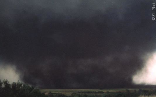
The term was first used during the May 3, 1999 tornado outbreak that spawned an F5 tornado which struck the municipalities of Bridge Creek and Moore, located just south of Oklahoma City, followed by southern and eastern parts of the city itself, Del City, and Midwest City. On that day, between 5:30 and 6:30 p.m., David Andra, the Science and Operations Officer at the National Weather Service Weather Forecast Office in Norman watched as the large, destructive tornado approached Oklahoma City. This led to the issuance of the first tornado emergency, which in this instance was released as a standalone weather statement issued separately from the original tornado warning.
"As the large tornado approached western sections of the OKC metro area, we asked ourselves more than once, 'Are we doing all we can do to provide the best warnings and information?' It became apparent that unique and eye-catching phrases needed to be included in the products. At one point we used the phrase 'Tornado Emergency' to paint the picture that a rare and deadly tornado was imminent in the metro area. We hoped that such dire phrases would prompt action from anyone that still had any questions about what was about to happen."
Text of the South Oklahoma City metro Tornado Emergency from May 3, 1999
...TORNADO EMERGENCY IN SOUTH OKLAHOMA CITY METRO AREA...AT 6:57 PM CDT...A LARGE TORNADO WAS MOVING ALONG INTERSTATE 44 WEST OF NEWCASTLE. ON ITS PRESENT PATH...THIS LARGE DAMAGING TORNADO WILL ENTER SOUTHWEST SECTIONS OF THE OKLAHOMA CITY METRO AREA BETWEEN 7:15 AND 7:30 PM. PERSONS IN MOORE AND SOUTH OKLAHOMA CITY SHOULD TAKE IMMEDIATE TORNADO PRECAUTIONS!THIS IS AN EXTREMELY DANGEROUS AND LIFE THREATENING SITUATION. IF YOU ARE IN THE PATH OF THIS LARGE AND DESTRUCTIVE TORNADO...TAKE COVER IMMEDIATELY.DOPPLER RADAR HAS INDICATED THIS STORM MAY CONTAIN DESTRUCTIVE HAIL TO THE SIZE OF BASEBALLS...OR LARGER.Text of the Kokomo, Indiana Tornado Emergency from August 24, 2016
Even though this tornado was only an EF-3 tornado, the tornado caused severe damage on the south side of Kokomo, Indiana, and was the only tornado emergency in Howard County history, and the second ever tornado emergency issued by the National Weather Service in Indianapolis.
SEVERE WEATHER STATEMENTNATIONAL WEATHER SERVICE INDIANAPOLIS IN325 PM EDT WED AUG 24 2016INC067-242000-/O.CON.KIND.TO.W.0023.000000T0000Z-160824T2000Z/HOWARD IN-325 PM EDT WED AUG 24 2016...TORNADO EMERGENCY FOR KOKOMO......A TORNADO WARNING REMAINS IN EFFECT UNTIL 400 PM EDT FOR EASTERNHOWARD COUNTY...AT 324 PM EDT...A CONFIRMED LARGE AND DESTRUCTIVE TORNADO WAS LOCATEDOVER KOKOMO...MOVING EAST AT 30 MPH.TORNADO EMERGENCY FOR KOKOMO. THIS IS A PARTICULARLY DANGEROUSSITUATION. TAKE COVER NOW!HAZARD...DEADLY TORNADO.SOURCE...LAW ENFORCEMENT CONFIRMED TORNADO.IMPACT...YOU ARE IN A LIFE-THREATENING SITUATION. FLYING DEBRIS MAY BE DEADLY TO THOSE CAUGHT WITHOUT SHELTER. MOBILE HOMES WILL BE DESTROYED. CONSIDERABLE DAMAGE TO HOMES... BUSINESSES...AND VEHICLES IS LIKELY AND COMPLETE DESTRUCTION IS POSSIBLE.THE TORNADO WILL BE NEAR... GREENTOWN AROUND 340 PM EDT.PRECAUTIONARY/PREPAREDNESS ACTIONS...TO REPEAT...A LARGE...EXTREMELY DANGEROUS...AND POTENTIALLY DEADLYTORNADO IS ON THE GROUND. TO PROTECT YOUR LIFE...TAKE COVER NOW! MOVETO AN INTERIOR ROOM ON THE LOWEST FLOOR OF A STURDY BUILDING. AVOIDWINDOWS. IF IN A MOBILE HOME...A VEHICLE OR OUTDOORS...MOVE TO THECLOSEST SUBSTANTIAL SHELTER AND PROTECT YOURSELF FROM FLYING DEBRIS.A LARGE AND EXTREMELY DANGEROUS TORNADO IS ON THE GROUND. TAKEIMMEDIATE TORNADO PRECAUTIONS. THIS IS AN EMERGENCY SITUATION.&&LAT...LON 4054 8586 4041 8586 4041 8613 4053 8613 4056 8600 4056 8587TIME...MOT...LOC 1924Z 265DEG 25KT 4048 8608TORNADO...OBSERVEDTORNADO DAMAGE THREAT...CATASTROPHICHAIL...1.00IN$$RYANSource:
Evolved usage
At 3:01 p.m. CDT on May 20, 2013, this bulletin was issued by the National Weather Service Norman forecast office confirming that a destructive tornado was on the ground and headed for Moore and southern portions of Oklahoma City, Oklahoma. Note the differences between this bulletin and the first-ever bulletin from 1999. It should also be noted that this was issued during an updated tornado warning and not in a follow-up severe weather statement.
Text of the Moore Tornado Emergency from May 20, 2013
BULLETIN - EAS ACTIVATION REQUESTEDTORNADO WARNINGNATIONAL WEATHER SERVICE NORMAN OK301 PM CDT MON MAY 20 2013THE NATIONAL WEATHER SERVICE IN NORMAN HAS ISSUED A* TORNADO WARNING FOR... NORTHWESTERN MCCLAIN COUNTY IN CENTRAL OKLAHOMA... SOUTHERN OKLAHOMA COUNTY IN CENTRAL OKLAHOMA... NORTHERN CLEVELAND COUNTY IN CENTRAL OKLAHOMA...* UNTIL 345 PM CDT* AT 259 PM CDT...NATIONAL WEATHER SERVICE METEOROLOGISTS AND STORM SPOTTERS WERE TRACKING A LARGE AND EXTREMELY DANGEROUS TORNADO NEAR NEWCASTLE. DOPPLER RADAR SHOWED THIS TORNADO MOVING NORTHEAST AT 20 MPH.THIS IS A TORNADO EMERGENCY FOR MOORE AND SOUTH OKLAHOMA CITY.IN ADDITION TO A TORNADO...LARGE DESTRUCTIVE HAIL UP TO TENNIS BALLSIZE IS EXPECTED WITH THIS STORM.* LOCATIONS IMPACTED INCLUDE... MIDWEST CITY...MOORE...NEWCASTLE...STANLEY DRAPER LAKE...TINKER AIR FORCE BASE AND VALLEY BROOK.PRECAUTIONARY/PREPAREDNESS ACTIONS...THIS IS AN EXTREMELY DANGEROUS AND LIFE THREATENING SITUATION. IF YOUCANNOT GET UNDERGROUND GO TO A STORM SHELTER OR AN INTERIOR ROOM OF ASTURDY BUILDING NOW.TAKE COVER NOW IN A STORM SHELTER OR AN INTERIOR ROOM OF A STURDYBUILDING. STAY AWAY FROM DOORS AND WINDOWS.&&$$Source:
Standardization and recent usage
After the original usage for the May 3, 1999 F5 tornado, the term Tornado Emergency was used by other National Weather Service Weather Forecast Offices (WFOs), although no uniform criteria existed and the issuance was entirely at the discretion of the forecaster issuing the warnings. Usage of the term varied from simply confirmed tornadoes in populated areas to significant, rare tornadoes causing severe damage and injuries. Some NWS forecast offices, such as the one serving the Des Moines, Iowa metropolitan area, have created standardized criteria and purpose for the usages of the heightened wording. Because data about the tornado and its exact path are often ascertained after the initial tornado warning is issued, this designation is usually added to the Severe Weather Statement (SAME code: SVS) that is used to follow up a tornado warning.
On April 2, 2012, the National Weather Service began an experimental program within its Wichita, Topeka, Springfield, St. Louis and Kansas City/Pleasant Hill offices in Kansas and Missouri called Impact Based Warning, which allows the respective offices to enhance warning information, such as adding tags to the warning messages which signify the potential damage severity. In regards to tornadoes, the creation of this multi-tiered system resulted in the implementation of an intermediate tornado warning product, a Particularly Dangerous Situation Tornado Warning.
On April 1, 2013, the IBW experiment expanded to include all National Weather Service WFOs within the Central Region; the IBW experiment was expanded again to include eight additional offices within the Eastern, Southern and Western Regions in the spring of 2014. Within the span of eleven days, the National Weather Service WFO in Norman issued tornado emergencies for parts of the Oklahoma City metropolitan area and central Oklahoma: first on May 20, 2013 for the EF5 tornado that struck Moore and portions of southern Oklahoma City, and again on May 31, for portions of eastern Canadian County and western sections of the immediate Oklahoma City area for another tornado.
The usage of tornado emergencies to alert major population centers to the imminent threat of a catastrophic tornado impact has also led to the development of the flash flood emergency which is similarly employed when severe flash floods threaten populated areas.
Criteria
The National Weather Service Weather Forecast Office in Des Moines is one of the forecast offices to have created a set purpose and criteria for the usage of "tornado emergencies" in tornado warning products, which were made effective on March 12, 2010. According to the Des Moines office, the purpose of the tornado emergency wording is as follows:
And before usage, the following criteria must be met:
The National Weather Service office in Nashville, Tennessee also created criteria to declare a tornado emergency within a tornado warning statement effective January 1, 2011. It states, "Tornado Emergency can be inserted in the third bulletin of the initial tornado warning (TOR) or in a severe weather statement (SVS)." Before the phrase can be used:
The Washington, Illinois tornado on November 17, 2013 did not prompt a Tornado Emergency; however, it affected many people. The Town of Washington is not populated enough; however, it has a population of approximately 15,000 residents. The National Weather Service in Lincoln may have similar criteria, however.
Tornado safety
It is recommended that people in the path of a large and violent tornado, whether referenced in a tornado warning or a tornado emergency, seek shelter in a basement, cellar or safe room, as stronger tornadoes (particularly those significant enough to warrant the inclusion of a tornado emergency declaration within a tornado warning) pose a significant risk of major injury or death for people above ground level. Those who do not have below-ground shelter are still advised to take cover in a room in the center of the home on the lowest floor, and cover themselves with some type of thick padding (such as mattresses or blankets), to protect against falling debris in the event that the roof and ceiling collapse.