Origin time 10:16:10 UTC Depth 90 km (56 mi) Date 30 September 2009 | Magnitude 7.6 Mw Type Reverse Max. intensity VII (Very strong) Number of casualties 1,115 | |
 | ||
Similar 1833 Sumatra earthquake, September 2007 Sumatra, 2006 Yogyakarta earthquake, 2010 Mentawai earthqua, 2012 Indian Ocean ea | ||
Padang earthquake sept 30 2009 sumatra indonesia
The September 2009 Sumatra earthquake (Indonesian: Gempa bumi Sumatra 2009) occurred on September 30 off the coast of Sumatra, Indonesia with a moment magnitude of 7.6 at 17:16:10 local time. The epicenter was 45 kilometres (28 mi) west-northwest of Padang, Sumatra, and 220 kilometres (140 mi) southwest of Pekanbaru, Sumatra. Government reports have to date confirmed 1,115 dead, 1,214 severely injured and 1,688 slightly injured. The most deaths occurred in the areas of Padang Pariaman (675), Padang (313), Agam (80) and Pariaman (37). In addition, around 135,000 houses were severely damaged, 65,000 houses were moderately damaged and 79,000 houses were slightly damaged. An estimated 250,000 families (1,250,000 people) have been affected by the earthquake through the total or partial loss of their homes and livelihoods.
Contents
- Padang earthquake sept 30 2009 sumatra indonesia
- Tectonic setting
- Earthquakes
- Effects
- Response
- References
Tectonic setting
The whole of Indonesia except Borneo, Bangka Belitung, Riau Islands and Timor is situated within a zone of high seismic activity known as the Pacific Ring of Fire. Along the Sunda megathrust, the Indo-Australian Plate is being subducted beneath the Eurasian plate. The subduction creates regular earthquakes, many of them of megathrust type. Specifically the Sumatran segment is currently experiencing a period of increased activity that began with the catastrophic 2004 Indian Ocean earthquake. Each earthquake of the sequence adds additional stresses to segments of the plate boundary that have not moved recently.
Earthquakes
Because of its depth and the computed focal mechanism, the first earthquake is thought to have resulted from deformation within the mantle of the descending Australian plate, rather than from movement on the plate boundary itself. A second event, which measured 6.6 Mw, struck the province of Jambi in central Sumatra, 01:52:29 local time on 1 October 2009 at a depth of 15 kilometres (9.3 mi), about 46 kilometres south-east of Sungaipenuh. Although it was in the same region, the United States Geological Survey specified that it was not an aftershock, as it was located too far from the initial quake. The second earthquake has been linked to dextral (right-lateral) movement on the Great Sumatran fault, which takes up the strike-slip component of the convergence between the two plates.
Effects
Tremors from the first earthquakes were felt in the Indonesian capital, Jakarta, Malaysia and Singapore. The management of some high-rise buildings in Singapore evacuated their staff.
A tsunami watch was triggered and there was reports of house damage and fires. Hotels in Padang were destroyed, and communications to the city were disrupted.
Local news channel Metro TV reported fires in Padang where residents had run onto the streets as the first quake hit. Teams of rescuers from nearby branches of the National Search and Rescue Agency have been deployed to Padang. It was also reported that some water pipes in Padang were broken and there was flooding in the street. There have also been reports that at least two hospitals and several schools have collapsed.
There were landslides and collateral debris flows in the hills surrounding Lake Maninjau. The landslide in Gunung Nan Tigo, Padang Pariaman district completely destroyed some villages and caused many fatalities. Landslides also forced some roads to be closed.
Padang's Minangkabau International Airport suffered minor damage, with parts of the ceiling in the boarding area falling down. The airport reopened on 1 October.
Response
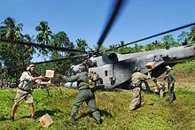
Authorities announced that several disaster management teams were en route to Padang although it took several hours for them to reach more remote areas. Rescue workers pulled dozens of survivors from the rubble and rushed them to Djamil Hospital. The hospital itself was overwhelmed with patients, and many patients were treated in tents set up outside the hospital. A man was trapped beneath a flattened hotel for 25 hours with a broken leg before rescue workers pulled him free. The Indonesian military deployed emergency response teams with earth moving equipment to help move rubble and recover trapped victims. Rescue workers and volunteers searched the rubble of a collapsed 3-story course building, rescuing survivors and recovering bodies while parents waited nearby. Indonesian villagers used their bare hands to sift through ruins and try to find survivors. On October 5, Indonesian rescue workers called off their search for trapped survivors and increased efforts to recover bodies, clear rubble, and provide aid to survivors. Indonesian authorities used helicopters to airdrop instant noodles, blankets, milk, and dry food into remote areas, and to bring the wounded from these areas to hospitals.
World Vision, Oxfam, IFRC, Muslim Charity and Mercy Corps confirmed that they would fly their emergency response teams to the devastated Padang area for rapid assessment of the catastrophe. The Red Cross sought donations to help cover earthquake relief costs. World Vision has also airlifted 2,000 collapsible water containers and will distribute them immediately to the area most affected by earthquake. Additionally World Vision has launched US$1 million appeal for the relief effort.
Below is the table of countries that have sent or pledged aid for Indonesia
