
First system formed May 29, 2008 Total storms 17 | Last system dissipated November 5, 2008 Total depressions 19 Hurricanes 7 | |
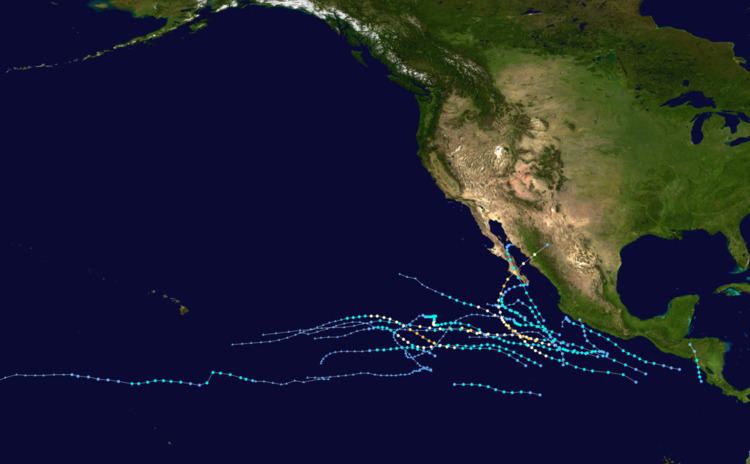 | ||
The 2008 Pacific hurricane season was a near average hurricane season. It officially started May 15, 2008 in the eastern Pacific, started on June 1, 2008 in the central Pacific, and lasted until November 30, 2008. This season is the first since 1996 to have no cyclones cross into the central Pacific. Activity this year was near average, with 16 storms forming in the Eastern Pacific proper and an additional 1 in the Central Pacific. There were 7 hurricanes, a low number compared to the typical 9, and only 2 major hurricanes, unlike the typical 5. There were only a few notable storms this year. Tropical Storm Alma made landfall along the Pacific coast of Nicaragua, becoming the first known storm to do so. It killed 9 and did $35 million in damage (2008 USD). It also became the first tropical storm to be retired in the Eastern Pacific basin. Hurricane Norbert became the strongest hurricane to hit the western side of the Baja Peninsula on record, killing 25.
Contents
- Seasonal forecasts
- Tropical Storm Alma
- Hurricane Boris
- Tropical Storm Cristina
- Tropical Storm Douglas
- Tropical Depression Five E
- Hurricane Elida
- Hurricane Fausto
- Hurricane Genevieve
- Hurricane Hernan
- Tropical Storm Kika
- Tropical Storm Iselle
- Tropical Storm Julio
- Tropical Storm Karina
- Tropical Storm Lowell
- Hurricane Marie
- Hurricane Norbert
- Tropical Storm Odile
- Tropical Depression Seventeen E
- Tropical Storm Polo
- Accumulated cyclone energy ACE
- Storm names
- Retirement
- Season effects
- References
Seasonal forecasts
On May 22, 2008, NOAA released their forecast for the 2008 Eastern Pacific and Central Pacific hurricane seasons. They predicted a below-normal level of activity in the Eastern Pacific, with 11 to 16 named storms, of which 5 to 8 were expected to become hurricanes, and 1 to 3 expected to become major hurricanes.
The Central Pacific basin was also expected to be slightly below average, with three to four tropical cyclones expected to form or cross into the area.
Tropical Storm Alma
An area of low pressure formed early on May 27 about 220 nmi southwest of Nicaragua. it then intensified and became the first tropical depression of the 2008 season late the next day. It then strengthened into a tropical storm early on May 29, and was named Alma. Alma then rapidly strengthened reaching her peak winds of 70 mph just before it made landfall on the Northwestern coast of Nicaragua near León at peak strength.
León lost electricity and telephone services as the storm impacted the area, trees were toppled and some houses lost roofs. In total nine people were killed with seven of them being indirect; the two direct deaths were in Nicaragua in León. On May 30 the remnant low of Alma emerged into the Gulf of Honduras and merged with a tropical wave over the northwestern Caribbean Sea which then became Tropical Storm Arthur later that day.
Hurricane Boris
Hurricane Boris originated form a tropical wave that left Africa in mid-June. Entering the Eastern Pacific basin on June 22 and became a tropical cyclone five days later, With warm waters and low wind shear, its local area was conducive for development and slight strengthening occurred. At 8 a.m PDT (1500 UTC) Tropical Depression Two E was upgraded to Tropical Storm Boris. With warm waters and low wind shear, its local area was deemed to be conducive for development and slight strengthening was predicted. After holding steady for about 48 hours, Boris intensified to a strong tropical storm late on June 29, and to a hurricane on July 1. Boris held hurricane status for most of the day before briefly weakening to a tropical storm. Boris reached its peak the next day as an 80 mph hurricane. Shortly after its peak, Boris moved over cooler waters and began to weaken. Boris was downgraded to a tropical storm late on July 2, and continued to weaken to a tropical depression on July 3. It dissipated on July 4 over cool waters. The remnant low dissipated July 6 while crossing into the Central Pacific.
Tropical Storm Cristina
An area of low pressure developed into Tropical Depression Three-E on June 27 to the west of Hurricane Boris. It strengthened the next day into Tropical Storm Cristina, and remained a relatively weak tropical storm as it tracked westward. It weakened to a tropical depression on June 30 as shear increased causing it to dissipate later that day.
Tropical Storm Douglas
A tropical wave exited the coast of Africa on June 19 and failed to organize until entering the Pacific Ocean on June 27. On June 28, deep convection and a broad circulation developed along the wave to the south of the Gulf of Tehuantepec. After the circulation organized further while moving to the northwest, the system developed into a tropical depression early on July 1, about 245 nmi (454 km) southwest of Manzanillo, Mexico. Due to northeasterly wind shear, the elongated center was displaced to the north of the convection. Despite the shear, rainbands developed to the south and west of the storm. The depression continued to become better organized and on July 2, the National Hurricane Center (NHC) upgraded it to Tropical Storm Douglas.
Upon being upgraded to a tropical storm, the circulation was located to the northeast of the convection, which gradually weakened over time. Increased shear and cooler waters caused Douglas to deteriorate, and on July 3 it weakened to a tropical depression after the deep convection dissipated. Douglas degenerated into a remnant low early on July 4, the remnant low moved westward for two days before dissipating. Due to the proximity to land, outer rain bands associated with Douglas produced tropical storm force winds in Manzanillo, Mexico. Minor flood damage was reported along the coastline in Colima, Jalisco, and Nayarit. Due to the proximity to land, the outerbands of Douglas produced tropical storm force winds in Manzanillo, Mexico. Minor flooding was reported along the coastline in Colima, Jalisco, and Nayarit. Moisture associated with Douglas produced light rain over parts of Baja California Sur, with heavier amounts in Todos los Santos.
Tropical Depression Five-E
In early July, a strong tropical wave southwest of the Mexican coast slowly developed. It became Tropical Depression Five-E on July 5. It then headed west-northwest before turning more northwest and making landfall near Lázaro Cárdenas, Mexico on July 7. The storm dissipated shortly after landfall. Its remnants brought rainfall to southern Mexico, but caused no severe flooding, casualties, or serious damage in its path.
Hurricane Elida
Late on July 11, an area of low pressure situated a few hundred miles south of the Gulf of Tehuantepec acquired sufficient organized convection to be classified as Tropical Depression Six-E. The depression soon strengthened into Tropical Storm Elida. On July 13, Elida slowly gained strength as it was near Mexico. Overnight on July 14, Elida strengthened into the second hurricane of the season as it pulled away from the coast.
After remaining stable in intensity for two days, it rapidly strengthened on July 16 into a Category 2 hurricane. That day Elida peaked as a 105 mph (165 km/h) Category 2 hurricane, the strongest of the season at that time. Only Hurricane Hernan was stronger. Elida was a Category 2 for about 36 hours and later weakened into a Category 1 hurricane.
Twelve hours after Elida weakened to a Category 1, Elida weakened to a tropical storm. Elida weakened to a tropical depression on July 19 as the low became exposed and dissipated that afternoon.
A few days later the wave slowly gained convection as it crossed in the CPHC area of responsibility, however as it neared Hawaii its chance of regeneration diminished.
Elida's outer rainbands reached Mexico. However, no watches or warnings were issued. Elida was briefly forecast to make landfall in Hawaii, however the storm dissipated before it hit the state. The remnants of Elida did bring showers in Hawaii.
Hurricane Fausto
Tropical Depression Seven-E formed from an area of low pressure on July 16 about 560 mi (905 km) SE of Acapulco. It strengthened into Tropical Storm Fausto that afternoon. It strengthened gradually into a strong tropical storm on July 17 and a hurricane on July 18. It briefly reached Category 2 intensity on July 20 while southwest of the Baja California peninsula before weakening rapidly that afternoon back to a tropical storm. It dissipated on July 22 over cooler waters. After a post-storm analysis review, Fausto was found to have peaked just below Category 2 status.
Hurricane Genevieve
A vigorous tropical wave tracked across Central America (nearly becoming a tropical depression in the southwest Caribbean Sea) in the third week of July. It emerged into the Pacific and organized into Tropical Depression Eight-E on July 21. That afternoon it strengthened into Tropical Storm Genevieve. It strengthened into a 65 mph storm, but soon weakened because of cooler water that Hurricane Fausto had passed over. On July 25, it strengthened and briefly reached hurricane status, which it remained at until weakening to a tropical storm early on July 26, and a remnant low the next day. The remnant low pressure area brought showers to Hawaii on August 3 and 4.
Hurricane Hernan
On July 24 a tropical wave moved off the coast of Africa and traversed the Atlantic before entering the Pacific Ocean on August 2. By August 5, an area of low pressure developed along the wave. Convection associated with the low quickly developed and the low was declared a tropical depression the next day while located 775 mi (1230 km) to the south-southwest of the southern tip of Baja California. Roughly twelve hours later, the depression was upgraded to a tropical storm and named Hernan. Hernan gradually intensified, reaching hurricane status on August 8 and major hurricane status (having winds of 111 mph (178 km/h) or higher) on August 9 after rapidly intensifying. Hernan reached its peak intensity with winds of 120 mph (195 km/h) with a minimum pressure of 956 mbar (hPa; 28.24 inHg) at 1200 UTC on August 9. Over the next several days, the combination of an eyewall replacement cycle and cooler waters caused the hurricane to weaken to a tropical storm on August 12. Shower and thunderstorm activity diminished throughout the rest of the day and Hernan degenerated into a remnant low early the next morning. The low moved in a general west-southwesterly direction and dissipated on August 16 while located 460 mi (740 km) southeast of the Island of Hawaii.
Tropical Storm Kika
On the morning of August 5, the CPHC began monitoring an area of low pressure 1,200 mi (1,930 km) east-southeast of Hilo, Hawaii; the system became better organized later in the day as the system was classified as a tropical disturbance and was declared Tropical Depression One-C on August 7 850 mi (1,370 km) southeast of Hilo, Hawaii. One-C was being steered toward the west due to easterly trade winds caused by large subtropical high pressure area located northeast of Hawaii. The depression was quickly upgraded to Tropical Storm Kika later that night. Despite strong wind shear, the storm was expected to attain winds at 60 mph (95 km/h). However, this did not occur. After turning west-northwest and attaining peak intensity, Kika became less organized the following morning and the CPHC subsequently downgraded it to a tropical depression. After a revival in convection
Kika was re-upgraded to a tropical storm again that evening. Even though wind shear was significantly diminishing, the storm became even less organized was moving over cooling water. Late on August 9, Kika weakened to a tropical depression once more, but was briefly re-upgraded into a tropical storm as it became better organized very late that night. By August 10, only isolated bursts of thunderstorms had remained around the center; as such, Kika was downgraded into a tropical depression. After a brief increase in thunderstorm activity, one Tropical cyclone forecast model showed Kika reaching hurricane status. Kika degenerated into a remnant low-pressure area that night 400 mi (645 km) away from the Johnston Atoll. The remnant low was last noted on August 14 as it crossed the International Date Line, out of the Central Pacific Hurricane Center's area of responsibility.
Tropical Storm Iselle
A disturbance moved through Costa Rica and Panama, and showed some good sign of strengthening while in that region. The disturbance then moved southwest of Mexico and showed no signs of strengthening until August 13, when it developed into Tropical Depression Ten-E. It further intensified into Tropical Storm Iselle, the ninth named storm of the season. Iselle reached its peak intensity of 50 mph, a moderate Tropical Storm, on August 14. No damage or deaths were linked to the storm. It never threatened any land masses. As Tropical Storm Iselle moved west, the cooler waters and northerly wind shear began to take its toll and it was downgraded to a tropical depression. Tropical Storm Iselle dissipated on August 16.
Tropical Storm Julio
On August 23, the National Hurricane Center (NHC) upgraded an area of low pressure which was located in the eastern Pacific ocean south of Baja California to Tropical Depression Eleven E. Later that morning, Tropical Storm Watches went up. That afternoon, the depression intensified into a tropical storm after a ship report supported tropical storm intensity. It made landfall in La Paz after becoming a tropical storm with 50 mph winds and a well-defined center, Mexico as a tropical storm on August 24, weakened, and dissipated August 26.
As Julio made landfall, it produced lightning and locally heavy rainfall, which left more than a dozen communities isolated due to flooding. The flooding damaged several houses and killed one person. Winds were generally light, although strong enough to damage a few electrical poles and small buildings. Moisture from Julio developed thunderstorms across Arizona, including one near Chandler which produced winds of 75 mph (120 km/h); the storm damaged ten small planes at Chandler Municipal Airport, as well as a hangar. The storms also dropped light rainfall, reaching over 1 inch (25 mm) in Gilbert, which caused flooding on Interstate 17.
Tropical Storm Karina
A disturbance tracked into the eastern Pacific near the end of August. It slowly organized itself, and was determined to have become Tropical Depression Eleven on the morning of September 2 and became a tropical storm that day and was named Karina. At first it was thought that it skipped tropical Depression status. On the afternoon of September 2 it reached it peak of 40 mph. Karina weakened to a tropical depression later the same day. The depression dissipated late the next morning.
Tropical Storm Lowell
Tropical Storm Lowell developed out of monsoonal trough located off the southwest coast of Mexico on the morning of September 5. A weak area of low pressure was found embedded within a large area of scattered moderate and isolated strong convection. The low failed to develop and was not mentioned in the tropical weather discussions for the rest of the day. On September 6, a new low had formed on the western side of the trough. The low was poorly defined but global forecast models were anticipating cyclogenesis within the next two days.
Southwest of Manzanillo, Mexico, the area of thunderstorms strengthened into Tropical Storm Lowell on the night of September 6. The system skipped tropical depression status and was named Lowell. Lowell slowly strengthened into a 50 mph Tropical Storm. A tropical storm watch was issued for southern Baja California as the storm headed north, but it weakened to a tropical depression on September 9. The next day Tropical Depression Lowell made landfall with 35 mph winds. It moved inland and dissipated on September 11. The remnants of Tropical Storm Lowell continued across the United States and joined with a cold front bringing heavy rains to the central northern states before tracking into Canada. It caused the heaviest rainstorm ever recorded in Chicago since records began in 1877.
Lowell made landfall as a tropical depression in Baja California but its effects where felt at more inland areas. In Michoacán, Sonora, and Sinaloa, flooding from Lowell's remnants left more than 26500 people homeless. No deaths were reported. Damage in Sonora totaled over 200 million pesos - $15.5 million in 2008 USD.
Moisture from Lowell eventually joined with a cold front and the remnants of Hurricane Ike and caused significant damage. As this conglomeration of moisture traveled through the United States it caused extensive flooding in Illinois. In Chicago it broke flooding records dating back to 1871.
Hurricane Marie
Marie originated from a tropical wave that emerged from the west coast of Africa on September 6. The wave moved quickly westward with little or no associated convection until it reached Central America about two weeks later. On September 24 when the wave emerged over the eastern North Pacific, a few weak bands of convection finally developed. However, this system showed no signs of having a closed surface circulation until September 28 when the system was located about 300 miles (480 km) south of Manzanillo, Mexico.
Tropical Depression Fourteen-E formed on October 1 from a broad area of low pressure SW of Baja California. It strengthened to become Tropical Storm Marie later the same day. Heading more or less westwards, by October 3 it became slow moving and strengthened into a hurricane, the sixth of the season. After unusually weak activity during the late August and September, Marie was the first hurricane since Hernan, two months earlier. Marie weakened at a steady pace until its winds reached 40 mph, a weak tropical storm. Shortly thereafter, it was downgraded to tropical depression status. As it was dissipating, Tropical Depression Marie degenerated into an open trough before being absorbed into Intertropical Convergence Zone on October 19.
Hurricane Norbert
Late in September, a vigorous tropical wave moved off the west coast of Mexico. By October 1, the National Hurricane Center issued a high probability (over 50% chance of development in the next 48 hours) for development into a tropical cyclone, but as the wave stalled offshore, it began losing vigor, with the NHC reducing the likelihood to medium (20-50% chance for development in the next 48 hours) the next day. As of 2100 UTC October 3, the likelihood of development within the next 48 hours was high again. Then, late that night, the wave developed into Tropical Depression Fifteen-E, and then into Tropical Storm Norbert 24 hours later.
Norbert ultimately became a hurricane on October 7 and rapidly intensified to a Category 2 hurricane and it became a major hurricane on October 8, the second of the season and the first since Hurricane Hernan. It continued to strengthen into a Category 4 hurricane before weakening back to a Category 3 by the morning of October 9, and weakened into a Category 1 hurricane that afternoon, but restrengthened into a Category 2 the next day, and became a minimal major hurricane the next morning, and it made landfall in Baja California as a Category 2 later that morning. Norbert then hit the mainland of Mexico as a Category 1 hurricane, killing 8. The final advisory on Norbert was issued on the morning of October 12.
Hurricane Norbert struck Mexico's Baja California peninsula with torrential rains and winds of up to 155 km/h. Strong winds bent palm trees along coastal areas. Some streets were in knee-deep water in the town of Puerto San Carlos. Norbert ripped off roofs, knocking down trees and left one person missing and more than 20,000 homes without electricity, local authorities say. Some 2850 people were housed in temporary shelters. Forty percent of homes were totally or partially damaged on the islands of Margarita and Magdalena, mainly having lost their roofs, said a report from state protection services. La Paz international airport suspended its activities at midday local time Saturday, but the tourist resort of Los Cabos remained open. Hotel reservations were down by around 40 per cent mainly in Los Cabos and Loreto, local tourism officials said.
Norbert was a Category 2 hurricane at landfall, which made Norbert the first October hurricane to strike the western Baja California peninsula since Hurricane Pauline forty years prior, and Norbert was the stronger of the two.
Tropical Storm Odile
In early October, a tropical wave formed near Nicaragua. Remaining Stationary until October 6 or October 7, the wave dumped heavy rain on the area, although damages or deaths, if any, have yet to be reported. On October 8, the wave became better organized as the National Hurricane Center increased the odds of development from the system. Then, later that day, the wave developed into Tropical Depression Sixteen-E, the sixteenth tropical cyclone of the active season. On the morning of October 9, it became Tropical Storm Odile, a short lived storm while located southwest of Guatemala.
Odile slowly strengthened over the next few days. On October 10 tropical storm watches were issued in Mexico as it strengthened into a tropical storm with winds of 60 mph. That night Odile made it closest approach to the area it came within 50 miles (80 km). After making it closest approach to Mexico, an Aircraft investigated Odile as it peaked as a 65 mph tropical storm. Over the next several days, however, Odile slowly weakened and dissipated on October 12, the same day that Hurricane Norbert met its demise.
Eighteen hours after it was named, a Tropical Storm Watch was issued from Punta Maldonado to Zihuatanejo. It was replaced with a warning 12 hours later. Before becoming a tropical wave, the precursor disturbance to Odile dumped heavy rainfall on Nicaragua, although any impact is unknown. Odile also caused heavy rain in Mexico. The system caused floods in Acapulco, which left 12 homes damaged.
Tropical Depression Seventeen-E
An area of disturbed weather had been tracked west for a few days, until Tropical Depression Seventeen-E formed rapidly on October 23 a few hundred miles south of Manzanillo. It dissipated the next day while over very cold waters and unfavorable upper level winds without reaching tropical storm status, the remnant low of this system moved west for next couple of days before it dissipated in the open sea.
Tropical Storm Polo
On October 31, the NHC began monitoring an area of disturbed weather south of the Mexican coast, noting the possibility for tropical cyclone formation. Strong convection lacked until November 2, when the NHC designated the area of low pressure 990 mi (1590 km) south of the southern tip of Baja California as Tropical Depression Eighteen-E. Existing at a low latitude, it slowly strengthened until it became a tropical storm and received the name Polo, the seventeenth named storm of the season. When it was named, the NHC forecasted Polo to become a strong tropical storm, but it remained a weak tropical storm with 45 mph winds, barely holding on to tropical storm status. It remained a storm at the same intensity until November 4. At that time it was downgraded to a depression. The same day the storm was declared dissipated because it had degenerated into an open trough.
Accumulated cyclone energy (ACE)
The table on the right shows the ACE for each storm in the season. ACE is, broadly speaking, a measure of the power of the hurricane multiplied by the length of time it existed, so storms that last a long time, as well as particularly strong hurricanes, have high ACEs. ACE is only calculated for full advisories on tropical systems at or exceeding 34 knots (39 mph, 63 km/h) or tropical storm strength.
The figures in parentheses are for storms in the Central Pacific basin west of 140°W; those not in parenthesis are for the Eastern Pacific basin.
Storm names
The following names were used for named storms that formed in the northeast Pacific in 2008. The names not retired from this list were used again in the 2014 season. This was the same list that was used in the 2002 season, except for Karina, which replaced Kenna. The name Karina was used for the first time in 2008. Names that weren't used are marked in gray.
For storms that form in the Central Pacific Hurricane Center's area of responsibility, encompassing the area between 140 degrees west and the International Date Line, all names are used in a series of four rotating lists. The only name used was Kika.
Retirement
After the season the World Meteorological Organization's Hurricane Committee retired the name Alma from the Eastern Pacific naming list and replaced it with Amanda.
Season effects
This is a table of the storms in 2008 and their landfall(s), if any. Deaths in parentheses are indirect; an example of such would be a traffic accident, but still storm-related. Damage and death totals include times when the storm was an extratropical storm or precursor wave.