
First system formed July 14, 2002 Total storms 12 | Last system dissipated October 16, 2002 Total depressions 14 Hurricanes 4 | |
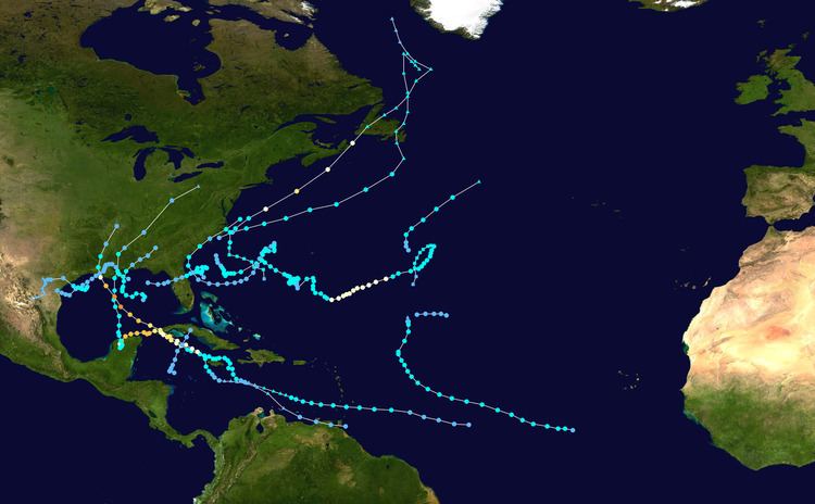 | ||
The 2002 Atlantic hurricane season was a near average Atlantic hurricane season, officially starting on June 1, 2002 and ending on November 30, dates which conventionally limit the period of each year when most tropical cyclones develop in the Atlantic Ocean. The season produced 14 tropical cyclones, of which 12 developed into named storms; four became hurricanes, and two attained major hurricane status. The season officially began on June 1, although the season's first cyclone did not develop until July 14. Despite the late start, the 2002 season tied with 2004, 2007, and 2010 in which a record number of tropical storms, eight, developed in the month of September. It ended early however, with no tropical storms forming after October 6—a rare occurrence caused partly by El Niño conditions. The most intense hurricane of the season was Hurricane Isidore with a minimum central pressure of 934 mbar, although Hurricane Lili attained higher winds and peaked at Category 4. The season's low activity is reflected in the low cumulative accumulated cyclone energy (ACE) rating of 67. ACE is, broadly speaking, a measure of the power of the hurricane multiplied by the length of time it existed, so low number reflects the small number of strong storms and preponderance of tropical storms.
Contents
- Seasonal forecasts
- Pre season forecasts
- Mid season forecasts
- Tropical Storm Arthur
- Tropical Storm Bertha
- Tropical Storm Cristobal
- Tropical Storm Dolly
- Tropical Storm Edouard
- Tropical Storm Fay
- Tropical Depression Seven
- Hurricane Gustav
- Tropical Storm Hanna
- Hurricane Isidore
- Tropical Storm Josephine
- Hurricane Kyle
- Hurricane Lili
- Tropical Depression Fourteen
- Storm names
- Season effects
- References
The season was less destructive than average, causing an estimated $2.6 billion (2002 USD) in property damage and 23 fatalities. Most destruction was due to Isidore, which caused about $970 million (2002 USD, $1.29 billion 2017 USD) in damage and killed seven people in the Yucatán Peninsula and later the United States, and Hurricane Lili, which caused $860 million (2002 USD) in damage and 15 deaths when it made landfall in Louisiana.
Seasonal forecasts
Noted hurricane expert William M. Gray and his associates at Colorado State University issue forecasts of hurricane activity each year, separately from the National Oceanic and Atmospheric Administration (NOAA). Gray's team determined the average number of storms per season between 1950 and 2000 to be 9.6 tropical storms, 5.9 hurricanes, and 2.3 major hurricanes (storms exceeding Category 3). A normal season, as defined by NOAA, has 9 to 12 named storms, of which 5 to 7 reach hurricane strength and 1 to 3 become major hurricanes.
Pre-season forecasts
On December 7, 2001, Gray's team issued its first extended-range forecast for the 2002 season, predicting above-average activity (13 named storms, 8 hurricanes, and about 2 of Category 3 or higher). It listed an 86 percent chance of at least one major hurricane striking the U.S. mainland. This included a 58 percent chance of at least one major hurricane strike on the East Coast, including the Florida peninsula, and a 43 percent chance of at least one such strike on the Gulf Coast from the Florida Panhandle westward. The potential for major hurricane activity in the Caribbean was forecast to be above average.
On April 5 a new forecast was issued, calling for 12 named storms, 7 hurricanes and 3 intense hurricanes. The decrease in the forecast was attributed to the further intensification of El Niño conditions. The estimated potential for at least one major hurricane to affect the U.S. was decreased to 75 percent; the East Coast potential decreased slightly to 57 percent, and from the Florida Panhandle westward to Brownsville, Texas, the probability remained the same.
Mid-season forecasts
On August 7, 2002, Gray's team lowered its season estimate to 9 named storms, with 4 becoming hurricanes and 1 becoming a major hurricane, noting that conditions had become less favorable for storms than they had been earlier in the year. The sea-level pressure and trade wind strength in the tropical Atlantic were reported to be above normal, while sea surface temperature anomalies were on a decreasing trend.
On August 8, 2002, NOAA revised its season estimate to 7–10 named storms, with 4–6 becoming hurricanes and 1–3 becoming major hurricanes. The reduction was attributed to less favorable environmental conditions and building El Niño conditions.
Tropical Storm Arthur
Arthur formed out of a tropical depression off the coast of North Carolina on July 14 from a decaying frontal zone. It then moved out to sea, strengthening slightly into a tropical storm on July 15. Arthur gradually strengthened and peaked as a 60 mph (97 km/h) tropical storm on the following day. However, cooler waters and upper level shear caused it to weaken. By July 17, Arthur had become extratropical, and moved north over Newfoundland. It proceeded to weaken below gale strength. The precursor system produced up to 4.49 in (114 mm) of rainfall in Weston, Florida. Later, one person drowned in the Conne River in Newfoundland due to Arthur.
Tropical Storm Bertha
A surface trough of low pressure that would later spawn Tropical Storm Cristobal developed a tropical depression in the northern Gulf of Mexico on August 4. It quickly strengthened into a minimal tropical storm early on August 5, and made landfall near Boothville, Louisiana just two hours later. Bertha weakened to a tropical depression, but retained its circulation over Louisiana. A high pressure system built southward, unexpectedly forcing the depression to the southwest. It emerged back over the Gulf of Mexico on August 7, where proximity to land and dry air prevented further strengthening. Bertha moved westward, and made a second landfall near Kingsville, Texas on August 9, having made no significant gain in strength.
Across the Gulf Coast of the United States, Bertha dropped light to moderate rainfall; most areas received less than 3 inches (76 mm). Precipitation from the storm peaked at 10.25 inches (260 mm) in Norwood, Louisiana. Minor flooding was reported, which caused light damage to a few businesses, 15 to 25 houses, and some roadways. Overall, damage was very minor, totaling to $200,000 (2002 USD, $266 thousand 2017 USD) in damage. In addition, one death was reported due to Bertha, a drowning due to heavy surf in Florida.
Tropical Storm Cristobal
On August 5, Tropical Depression Three formed off the coast of South Carolina from a surface trough of low pressure – the same trough that spawned Tropical Storm Bertha in the Gulf of Mexico. Under a southerly flow, the depression drifted southward, where dry air and wind shear inhibited significant development. On August 7, it became Tropical Storm Cristobal, and reached a peak of 50 mph (80 km/h) on August 8. The storm meandered eastward and was absorbed by a front on August 9.
The interaction between the extratropical remnant and a high pressure system produced strong rip currents along the coastline of Long Island. The storm also caused waves of three to four ft (1.2 m) in height. Three people drowned from the rip currents and waves in New York.
Tropical Storm Dolly
A tropical wave exited the African coast on August 27, and with low favorable conditions the system organized into Tropical Depression Four on August 29 about 630 mi (1,020 km) southwest of Cape Verde. Six hours later, the depression was upgraded to Tropical Storm Dolly after developing sufficient outflow and curved banding features. The storm continued to intensify as more convection developed, and Dolly reached peaked winds of 60 mph (95 km/h) on August 30. After peaking in intensity, the storm suddenly lost organization, and the winds decreased to minimal tropical storm force. After a brief re-intensification trend, Dolly again weakened due to wind shear. On September 4 Dolly weakened to a tropical depression, and later that day was absorbed by the trough; it never affected land.
Tropical Storm Edouard
Edouard formed out of an area of disturbed weather north of the Bahamas on September 2. It drifted northward, then executed a clockwise loop off the coast of Florida. Despite dry air and moderate upper level shear, Edouard strengthened to a peak of 65 mph (105 km/h) winds, but the unfavorable conditions caught up with it. The storm weakened as it turned west-southwestward, and made landfall near Ormond Beach, Florida on September 5 as a minimal tropical storm. Edouard crossed Florida, and emerged over the Gulf of Mexico as a minimal depression. Outflow from the stronger Tropical Storm Fay caused Tropical Depression Edouard to weaken further, and Edouard was eventually absorbed by Fay.
Tropical Storm Edouard dropped moderate rainfall across Florida, peaking at 7.64 inches (194 mm) in DeSoto County. Though it was a tropical storm at landfall, winds were light across the path of the storm over land. Several roads were flooded from moderate precipitation. No casualties were reported, and damage was minimal.
Tropical Storm Fay
In early September, a low pressure center developed along a trough of low pressure, and on September 5, the system had gained sufficient organization to be a tropical depression, to the southeast of Galveston. The depression drifted south-southwest while strengthening into Tropical Storm Fay, reaching its peak strength of 60 mph (95 km/h) on the morning of September 6. The system then abruptly turned to the west-northwest, and remained steady in strength and course until landfall the next day, near Matagorda. It quickly degenerated into a remnant low, which itself moved slowly southwestward over Texas. The low eventually dissipated on September 11 over northeastern Mexico.
The storm brought heavy rainfall in Mexico and Texas. The storm also caused six tornadoes, up to 20 in (510 mm) of rain, and extended periods of tropical storm force winds. The storm caused moderate flooding in some areas due to high rainfall amounts, which left about 400 homes with some form of damage. In total, 400 houses sustained damage from flooding. 1,575 houses were damaged from the flooding or tornadic damage, 23 severely, amounting to $4.5 million (2002 USD, $5.99 million 2017 USD) in damage. No deaths are attributed to Fay.
Tropical Depression Seven
A tropical wave exited Africa on September 1, and after initial development became disorganized. It moved west-northwestward for a week, reorganizing enough by September 7 to be declared Tropical Depression Seven about 1155 mi (1855 km) east-southeast of Bermuda. At the time, the depression had persistent convection around a small circulation, and it moved steadily westward due to a ridge to its north. Shortly after forming, strong wind shear diminished the convection and left the center partially exposed. By September 8, there was no remaining thunderstorm activity, and the depression degenerated into a remnant low-pressure area. The storm dissipated shortly after as strong wind shear continued to cause the storm to deteriorate while located 980 mi (1580 mi) southeast of Bermuda. The depression never affected land.
Hurricane Gustav
An area of unsettled weather developed between the Bahamas and Bermuda on September 6, and over the next few days convection increased in intensity and coverage. On September 8, the system gained sufficient organization to be declared a subtropical depression off the Southeast United States coast; later that day, the system was named Subtropical Storm Gustav. After attaining tropical characteristics on September 10, Gustav passed slightly to the east of the Outer Banks of North Carolina as a tropical storm before moving northeastward and making two landfalls in Atlantic Canada as a Category 1 hurricane on September 12.
The storm was responsible for one death and $100,000 (2002 USD) in damage, mostly in North Carolina. The interaction between Gustav and a non-tropical system produced strong winds that caused an additional $240,000 (2002 USD) in damage in New England, but this damage was not directly attributed to the hurricane. In Atlantic Canada, the hurricane and its remnants brought heavy rain, tropical storm and hurricane-force winds, as well as storm surges for several days. Localized flooding was reported in areas of Prince Edward Island, and 4,000 people in Halifax, Nova Scotia and Charlottetown, Prince Edward Island were left without power.
Tropical Storm Hanna
In early September, a tropical wave merged with a trough of low pressure in the Gulf of Mexico and spawned a low pressure system. Convection steadily deepened on September 11 east of the upper level low and the surface low; it was classified as Tropical Depression Nine the next day. The disorganized storm moved westward, then northward, where it strengthened into Tropical Storm Hanna later that day. After reaching a peak with winds of 55 mph (90 km/h), it made two landfalls on the Gulf Coast, eventually dissipating on September 15 over Georgia.
Because most of the associated convective activity was east of the center of circulation, minimal damage was reported in Louisiana and Mississippi. To the east on Dauphin Island, Alabama, the storm caused coastal flooding which closed roads and forced the evacuation of residents. Florida received high wind gusts, heavy rainfall, and strong surf that resulted in the deaths of three swimmers. Throughout the state, 20,000 homes lost electricity. The heavy rainfall progressed into Georgia, where significant flooding occurred. Crop damage was extensive, and over 300 structures were damaged by the flooding. The storm caused a total of about $20 million (2002 USD) in damage and three fatalities.
Hurricane Isidore
On September 9, a tropical wave moved off the coast of Africa, and by September 14 it was classified as a tropical depression. The next day the storm was located just south of Jamaica, and it developed into Tropical Storm Isidore. On September 19, it intensified into a hurricane, and Isidore made landfall in western Cuba as a Category 1 storm. Just before landfall near Puerto Telchac on September 22, Isidore reached its peak intensity, with wind speeds of 125 miles per hour (201 km/h), making it a strong Category 3 storm. After returning to the Gulf of Mexico as a tropical storm, Isidore's final landfall was near Grand Isle, Louisiana on September 26, where the storm weakened to a depression.
Isidore made landfall on the Yucatán Peninsula of southern Mexico as a Category 3 hurricane, leaving $640 million (2002 USD, $852 million 2017 USD) in damage in the country. Despite dropping over 30 inches (760 mm) of rainfall among other effects, only two indirect deaths were reported there. As a tropical storm, Isidore produced a maximum of 15.97 inches (406 mm) of rainfall in the United States at Metairie, Louisiana. The rainfall was responsible for flooding that caused moderate crop damage, with a total of $330 million in damage (2002 USD, $439 million 2017 USD).
Tropical Storm Josephine
A non-tropical low developed along a dissipating stationary front on September 16 in the central Atlantic and drifted north-northeastward. The National Hurricane Center classified it as Tropical Depression Eleven on September 17 about 710 mi (1,150 km) east of Bermuda, and initially the depression did not have significant deep convection. A wind report early on September 18 indicated the depression intensified into Tropical Storm Josephine. The storm continued generally northeastward, steered between a subtropical high to the northeast and a frontal system approaching from the west. Josephine maintained a well-defined circulation, but its deep convection remained intermittent. Early on September 19 the storm began being absorbed by the cold front, and as a tropical cyclone its winds never surpassed 40 mph (75 km/h). Later that day Josephine transitioned into an extratropical cyclone and suddenly intensified to winds of 60 mph (95 km/h). The extratropical low was quickly absorbed by another larger extratropical system on the afternoon of September 19.
Hurricane Kyle
A non-tropical low formed into Subtropical Depression Twelve, well east-southeast of Bermuda on September 20. It became Subtropical Storm Kyle the next day, and Tropical Storm Kyle on September 22. Kyle drifted slowly westward, slowly strengthening, and reached hurricane strength on September 25; it weakened back into a tropical storm on September 28. The cyclone's strength continued to fluctuate between tropical depression and tropical storm several times. Its movement was also extremely irregular, as it shifted sharply north and south along its generally westward path. On October 11, Kyle reached land and made its first landfall near McClellanville, South Carolina. While skirting the coastline of the Carolinas, it moved back over water, and made a second landfall near Long Beach, North Carolina later the same day. Kyle continued out to sea where it merged with a cold front on October 12, becoming the fourth longest-lived Atlantic hurricane.
Kyle brought light precipitation to Bermuda, but no significant damage was reported there. Moderate rainfall accompanied its two landfalls in the United States, causing localized flash flooding and road closures. Floodwaters forced the evacuation of a nursing home and several mobile homes in South Carolina. Kyle spawned at least four tornadoes, the costliest of which struck Georgetown, South Carolina; it damaged 106 buildings and destroyed seven others, causing eight injuries. Overall damage totaled about $5 million (2002 USD, $6.66 million 2017 USD), and no direct deaths were reported. However, the remnants of Kyle contributed to one indirect death in the British Isles.
Hurricane Lili
On September 16, a tropical wave moved off the coast of Africa and across the Atlantic. It developed a low level cloud circulation midway between Africa and the Lesser Antilles on September 20. The next day, the system had become sufficiently organized to classify the system as a tropical depression about 900 nautical miles (1,700 km) east of the Windward Islands. On September 30 Lili became a hurricane while passing over the Cayman Islands. The storm attained Category 4 status in the Gulf of Mexico before making landfall on the Louisiana coast on October 2. The next day, it was absorbed by an extratropical low near the Tennessee – Arkansas border.
In Louisiana, wind gusts reaching 120 mph (190 km/h), coupled with over 6 inches (150 mm) of rainfall and a storm surge of 12 feet (3.7 m), caused over $860 million (2002 USD, $1.15 billion 2017 USD) in damage. A total of 237,000 people lost power, and oil rigs offshore were shut down for up to a week.
Tropical Depression Fourteen
A weak tropical wave moved through the Lesser Antilles on October 9. As the system reached the southwestern Caribbean Sea on October 12, convection increased, and a broad low pressure area formed later that day. Over the next two days, the low significantly organized, and became Tropical Depression Fourteen at 1200 UTC on October 14. The depression initially tracked west-northwestward, but then curved to the north-northeast. Due to vertical wind shear, the depression was unable to intensify, and remained below tropical storm status during its duration. By 1600 UTC on October 16, the depression made landfall near Cienfuegos, Cuba with winds of 30 mph (45 km/h). While crossing the island, the depression was absorbed by a cold front early on October 17. Minimal impact was reported, which was limited to locally heavy rains over portions of Jamaica, Cuba, and the Cayman Islands.
Storm names
The following names were used on named storms that formed in the North Atlantic during the 2002 season. Names that were not used are marked in gray. The 2002 list was taken from the 1996 season with the substitution of Cesar, Fran, and Hortense for Cristobal, Fay, and Hanna respectively. The three new names were used for Atlantic storms for the first time. The list was used again in the 2008 Atlantic hurricane season with the exception of Isidore and Lili, which were retired in the spring of 2003 by the World Meteorological Organization; they were replaced with Ike and Laura, respectively. The name Ike, however, was retired after the 2008 season, being replaced by Isaias.
Season effects
The following table lists all of the storms that formed in the 2002 Atlantic hurricane season. It includes their duration, names, landfall(s) –denoted by bold location names – damages, and death totals. Deaths in parentheses are additional and indirect (an example of an indirect death would be a traffic accident), but were still related to that storm. Damage and deaths include totals while the storm was extratropical, a wave, or a low, and all of the damage figures are in 2002 USD.