
Duration 4-5 minutes. Max. intensity XI (Extreme) Depth 22,531 m Start date March 28, 1964 | Magnitude 9.2 Mw Peak acceleration 0.18 g Total damage 311 million USD | |
 | ||
Similar 1960 Valdivia earthquake, 1906 San Francisco earthquake, 1989 Loma Prieta earthquake, 2004 Indian Ocean ea, 1700 Cascadia earthquake | ||
Though the earth be moved the 1964 alaska earthquake
The 1964 Alaskan earthquake, also known as the Great Alaskan earthquake and Good Friday earthquake, occurred at 5:36 P.M. AST on Good Friday, March 27. Across south-central Alaska, ground fissures, collapsing structures, and tsunamis resulting from the earthquake caused about 139 deaths.
Contents
- Though the earth be moved the 1964 alaska earthquake
- Geology
- Tsunamis
- Death toll damage and casualties
- Anchorage area
- Elsewhere in Alaska
- Canada
- Elsewhere
- Aftershocks
- Recovery efforts
- References
Lasting four minutes and thirty-eight seconds, the magnitude 9.2 megathrust earthquake was the most powerful recorded in North American history, and the second most powerful recorded in world history. Soil liquefaction, fissures, landslides, and other ground failures caused major structural damage in several communities and much damage to property. Anchorage sustained great destruction or damage to many inadequately earthquake engineered houses, buildings, and infrastructure (paved streets, sidewalks, water and sewer mains, electrical systems, and other man-made equipment), particularly in the several landslide zones along Knik Arm. Two hundred miles southwest, some areas near Kodiak were permanently raised by 30 feet (9.1 m). Southeast of Anchorage, areas around the head of Turnagain Arm near Girdwood and Portage dropped as much as 8 feet (2.4 m), requiring reconstruction and fill to raise the Seward Highway above the new high tide mark.
In Prince William Sound, Port Valdez suffered a massive underwater landslide, resulting in the deaths of 30 people between the collapse of the Valdez city harbor and docks, and inside the ship that was docked there at the time. Nearby, a 27-foot (8.2 m) tsunami destroyed the village of Chenega, killing 23 of the 68 people who lived there; survivors out-ran the wave, climbing to high ground. Post-quake tsunamis severely affected Whittier, Seward, Kodiak, and other Alaskan communities, as well as people and property in British Columbia, Washington, Oregon, and California. Tsunamis also caused damage in Hawaii and Japan. Evidence of motion directly related to the earthquake was also reported from Florida and Texas.
Geology
At 5:36 p.m. Alaska Standard Time (3:36 a.m. March 28, 1964 UTC), a fault between the Pacific and North American plates ruptured near College Fjord in Prince William Sound. The epicenter of the earthquake was 12.4 mi (20 km) north of Prince William Sound, 78 miles (125 km) east of Anchorage and 40 miles (64 km) west of Valdez. The focus occurred at a depth of approximately 15.5 mi (25 km). Ocean floor shifts created large tsunamis (up to 220 feet (67 m) in height), which resulted in many of the deaths and much of the property damage. Large rockslides were also caused, resulting in great property damage. Vertical displacement of up to 38 feet (11.5 m) occurred, affecting an area of 100,000 miles² (250,000 km²) within Alaska.
Studies of ground motion have led to a peak ground acceleration estimate of 0.14–0.18 g.
The Alaska Earthquake was a subduction zone earthquake (megathrust earthquake), caused by an oceanic plate sinking under a continental plate. The fault responsible was the Aleutian Megathrust, a reverse fault caused by a compressional force. This caused much of the uneven ground which is the result of ground shifted to the opposite elevation.
Tsunamis
Two types of tsunamis were produced by this subduction zone earthquake. There was a tectonic tsunami produced in addition to about 20 smaller and local tsunamis. These smaller tsunami were produced by submarine and subaerial landslides and were responsible for the majority of the tsunami damage. Tsunami waves were noted in over 20 countries, including: Peru, New Zealand, Papua New Guinea, Japan, and Antarctica. The largest tsunami wave was recorded in Shoup Bay, Alaska, with a height of about 220 ft (67 m).
Death toll, damage, and casualties
As a result of the earthquake, 139 people are believed to have died: Fifteen died as a result of the earthquake itself, 106 died from the subsequent tsunami in Alaska, 5 died from the tsunami in Oregon, and 13 died from the tsunami in California. The quake was a reported XI on the modified Mercalli Intensity scale "indicating major structural damage, and ground fissures and failures". Property damage was estimated at about $311 million ($2.32 billion in current U.S. dollars).
Anchorage area
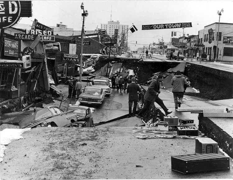
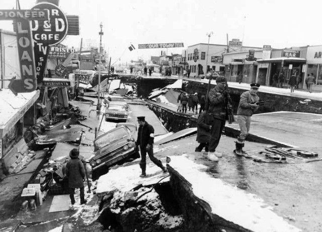
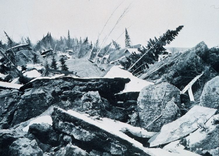
Most damage occurred in Anchorage, 75 mi (120 km) northwest of the epicenter. Anchorage was not hit by tsunamis, but downtown Anchorage was heavily damaged, and parts of the city built on sandy bluffs overlying "Bootlegger Cove clay" near Cook Inlet, most notably the Turnagain neighborhood, suffered landslide damage. The neighborhood lost 75 houses in the landslide, and the destroyed area has since been turned into Earthquake Park. The Government Hill school suffered from the Government Hill landslide leaving it in two jagged, broken pieces. Land overlooking the Ship Creek valley near the Alaska Railroad yards also slid, destroying many acres of buildings and city blocks in downtown Anchorage. Most other areas of the city were only moderately damaged. The 60-foot concrete control tower at the Anchorage International Airport was not engineered to withstand earthquake activity and collapsed, killing William George Taylor, the Federal Aviation Agency Air Traffic Controller on duty in the tower cab at the time the earthquake began.
One house on W. 10th Avenue suffered peripheral damage, but only one block away the recently completed (and still unoccupied) Four Seasons Building on Ninth Avenue collapsed completely, with the concrete elevator shafts sticking up out of the rubble like a seesaw.
The hamlets of Girdwood and Portage, located 30 and 40 mi (60 km) southeast of central Anchorage on the Turnagain Arm, were destroyed by subsidence and subsequent tidal action. Girdwood was relocated inland and Portage was abandoned. About 20 miles (32 km) of the Seward Highway sank below the high-water mark of Turnagain Arm; the highway and its bridges were raised and rebuilt in 1964–66.
Elsewhere in Alaska
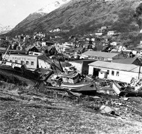
Most coastal towns in the Prince William Sound, Kenai Peninsula, and Kodiak Island areas, especially the major ports of Seward, Whittier and Kodiak were heavily damaged by a combination of seismic activity, subsidence, post-quake tsunamis and/or earthquake-caused fires. Valdez was not totally destroyed, but after three years, the town relocated to higher ground 7 km (4 mi) west of its original site. Some Alaska Native villages, including Chenega and Afognak, were destroyed or damaged. The earthquake caused the Cold-War era ballistic missile detection radar of Clear Air Force Station to go offline for six minutes, the only unscheduled interruption in its operational history. Near Cordova, the Million Dollar Bridge crossing the Copper River also collapsed. The community of Girdwood was also confined to the southern side of the Seward Highway when water rushed into Turnagain Arm and flooded or destroyed any buildings left standing to the north of the highway. Interestingly, only the ground immediately along the highway and that on the north side of the road dropped, prompting geologists to speculate that Girdwood may rest upon an ancient cliff face, now covered by countless thousands of years of sediment and glacial deposits.
Canada
A 4.5 ft (1.4 m) wave reached Prince Rupert, British Columbia, just south of the Alaska Panhandle, about three hours after the earthquake. The tsunami then reached Tofino, on the exposed west coast of Vancouver Island, and traveled up a fjord to hit Port Alberni twice, washing away 55 homes and damaging 375 others. The towns of Hot Springs Cove, Zeballos, and Amai also saw damage. The damage in British Columbia was estimated at $10 million Canadian (or $77.3 million in today's Canadian dollars, or $77.2 million in today's U.S. dollars).
Elsewhere
Twelve people were killed by the tsunami in or near Crescent City, California, while four children were killed on the Oregon coast at Beverly Beach State Park. Other coastal towns in the U.S. Pacific Northwest and Hawaii were damaged. Minor damage to boats occurred as far south as Los Angeles. Effects of the earthquake were even noted as far east as Texas. Tide gauges in Freeport recorded waves similar to seismic surface waves. In the Florida Everglades, an artesian aquifer located near Lake Chekika saw its water flow rate double from 3 million gallons per day to 6 million gallons per day, 60 to 90 minutes after the first shock of the earthquake.
Aftershocks
There were hundreds of aftershocks in the first weeks following the main shock. In the first day alone, eleven major aftershocks were recorded with a magnitude greater than 6.0. Nine more struck over the next three weeks. In all, thousands of aftershocks occurred in the months following the quake, and smaller aftershocks continued to strike the region for more than a year.
Recovery efforts
Alaska had never experienced a major disaster in a highly populated area before, and had very limited resources for dealing with the effects of such an event. The military, which has a large, active presence in Alaska, stepped in to assist within moments of the conclusion of the quake. The Army rapidly re-established communications with the lower 48, deployed troops to assist the citizens of Anchorage, and dispatched a convoy to Valdez. On the advice of military and civilian leaders, President Johnson declared the entirety of Alaska a major disaster area the day after the quake. The Navy and Coast Guard deployed ships to isolated coastal communities to assist with immediate needs. Bad weather and poor visibility hampered efforts at air rescue and observation efforts the day after the quake, but on Sunday the 29th the situation improved and rescue helicopters and observation aircraft were deployed. A military airlift immediately began shipping relief supplies to Alaska, eventually delivering 2,570,000 pounds (1,170,000 kg) of food and other supplies.
In the longer term, the US Army Corps of Engineers led the effort to rebuild roads, clear debris, and establish new townsites for communities that had been completely destroyed, at a cost of $110 million. The West Coast and Alaska Tsunami Warning Center was formed as a direct response to the disaster. Federal disaster relief funds paid for reconstruction as well as financially supporting the devastated infrastructure of Alaska's government, spending hundreds of millions of dollars that helped keep Alaska financially solvent until the discovery of massive oil deposits at Prudhoe Bay. At the order of the Defense Department, the Alaska National Guard founded the Alaska Division of Emergency Services to respond to any future disasters.