
Existed: 1923 – present AK-1 AK-2 → Constructed 1923 | Length 201.7 km | |
 | ||
South end: Railway Avenue in Seward Boroughs Kenai Peninsula Borough, Alaska, Anchorage | ||
Alaska road trip time lapse seward highway 2 hrs in 7 mins shot on contour 2
The Seward Highway is a highway in the U.S. state of Alaska that extends 125 miles (201 km) from Seward to Anchorage. It was completed in 1951 and runs through the scenic Kenai Peninsula, Chugach National Forest, Turnagain Arm, and Kenai Mountains. The Seward Highway is numbered Alaska Route 9 (AK-9) for the first 37 miles (60 km) from Seward to the Sterling Highway and AK-1 for the remaining distance to Anchorage. At the junction with the Sterling Highway, AK-1 turns west towards Sterling and Homer. About eight miles (13 km) of the Seward Highway leading into Anchorage is built to freeway standards. In Anchorage, the Seward Highway terminates at an intersection with 5th Avenue, which AK-1 is routed to, and which then leads to the Glenn Highway freeway.
Contents
- Alaska road trip time lapse seward highway 2 hrs in 7 mins shot on contour 2
- Map of Seward Hwy Alaska USA
- Seward highway alaska route 9 tern lake to seward scenic drive
- Route description
- Seward to Bear Creek
- Chugach National Forest
- Girdwood to Anchorage
- History
- US Bicycle Route 97
- Major intersections
- Old Seward Highway
- References
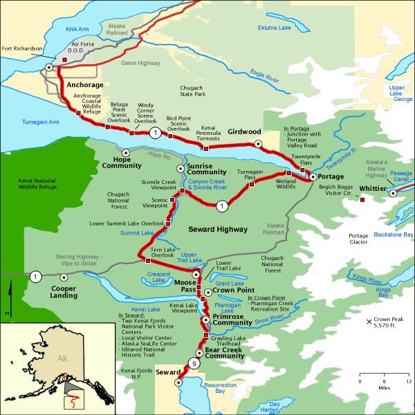
Map of Seward Hwy, Alaska, USA
Seward highway alaska route 9 tern lake to seward scenic drive
Route description
The full length of the Seward Highway has been listed on the National Highway System (NHS), a network of roads important to the country's economy, defense, and mobility. The segment designated AK-9 between Seward and Tern Lake Junction is part of the STRAHNET subsystem, highways that are important to defense policy and which provide defense access, continuity and emergency capabilities for defense purposes. The remainder that follows AK-1 is also designated Interstate A-1 (A-1) and included in the NHS on that basis. The state's Interstate Highways are not required to comply with Interstate Highway standards, instead "shall be designed in accordance with such geometric and construction standards as are adequate for current and probable future traffic demands and the needs of the locality of the highway" under federal law. The highway is maintained by the Alaska Department of Transportation & Public Facilities (Alaska DOT&PF), and the A-1 designation is not signed along the highway. In 2010, 2,520 vehicles used the highway near the junction with Sterling Highway in a measure of the annual average daily traffic, the lowest tally along the highway. The highest traffic count as recorded by Alaska DOT&PF was 58,799 vehicles daily at the Dowling Road overpass in Anchorage. In 2012, Life magazine included the Seward Highway in its list of Most Scenic Drives in the World.
Seward to Bear Creek
The Seward Highway begins at an intersection with Railway Avenue, in Seward, less than 300 feet (91 m) from the Gulf of Alaska. At this point, the Seward Highway is two lanes, with a parking lane on each side. The Seward Highway is designated as AK-9 at this point of the route. The highway continues through central Seward, passing several small businesses, houses, the Seward Museum, as well as several hotels and motels. The highway continues past the Seward Airport, before entering the unincorporated community of Bear Creek. Just after entering Bear Creek, a series of tracks belonging to the Alaska Railroad comes alongside the roadway. These railroad tracks continue on with the Seward Highway until Moose Pass, return near a junction with the Portage Glacier Highway, and remain until the highway becomes a freeway, in southern Anchorage. The Seward Highway proceeds through central Bear Creek, passing Bear Lake, until entering Chugach National Forest.
Chugach National Forest
The Seward Highway enters the Chugach National Forest just 5 miles (8.0 km) after its start. The highway enters the Chugach National Forest while it is still part of the Bear Creek community, so it gives the appearance of still being inside that census-designated place. After a mile or so (1.6 km) though, the area surrounding the highway begins to look more like a national forest. The Alaska Railroad weaves back and forth under the highway, which causes the highway to become a series of small bridges. For a few miles after the bridges, the Seward Highway is a four-lane road, but then merges back to two lane. After passing through about 10 miles (16 km) of forest, the highway passes Primrose Spur Road, and enters Primrose. For the next five or so miles (8 km), the route runs alongside Kenai Lake. Just before peeling off of Kenai Lake, the route passes though Crown Point, passes the single runway Lawling Airport, and provides access to a large campground. The highway runs alongside the Trail Creek for about 6 miles (9.7 km), before passing the settlement of Moose Pass. The road continues, passing along Upper Trail Lake for a few miles, before peeling off and returning to the dense forest, and passing a large mountain range. After a few more miles, the road passes the community of Tern Lake Junction, and intersects with Alaska Route 1 (AK-1), where Alaska Route 9 terminates, and the Seward Highway is designated to AK-1.
After that, for several miles, the roadway continues through large, Alaskan pine forests. After approximately 10 miles (16 km), the highway passes Summit Lake, and provides access to another large campground. The road then continues through a large mountain range on either side of the highway. After about 8 miles (13 km), the route intersects the Hope Highway, which provides access to the city of Hope, and the highway reenters forest. The roadway continues though forest for a brief period, and again enters the mountains. The route continues through the mountains for about 24 miles (39 km) more, before reaching the Turnagain Arm. Just after reaching the Turnagain Arm, the highway enters the city limits of Anchorage (and remains within Anchorage proper for the remainder of its route). After intersecting the Portage Glacier Highway the Alaska Railroad tracks again come alongside the route. The highway continues through the Chugach National Forest for approximately 8 miles (13 km), passing the Turnagain Arm to the west, and the Kenai Mountains to the east. It then exits the Chugach National Forest, having spent approximately 72 miles (116 km) inside its boundaries.
Girdwood to Anchorage
After the highway exits the National Forest, it continues for about 5 miles (8.0 km) through pine forest, before passing through the community of Girdwood. After about a mile, the highway enters Chugach State Park. The road continues through forest for about 10 miles (16 km) more, before passing the small skiing village of Bird. The route reenters the park for about a mile, before entering the village of Indian, and then reentering the forest. The Seward Highway passes along the coast of the Gulf of Alaska for about 12 miles (19 km), with the Kenai Mountains running along the northern side. The highway then proceeds to enter the central part of Anchorage. The highway intersects Old Seward Highway, before becoming a four-lane freeway. The freeway's first exit is, in fact, for Old Seward Highway. The freeway continues past several neighborhoods, a plant nursery, and Rabbit Creek Elementary School.
At an exit for De Armoun Road, the highway's frontage road begins. The freeway continues past dozens of neighborhoods, a few small businesses, and provides exits for a few small roads, including the Minnesota Drive Expressway. After the exit for Abbott Road, part of the frontage road terminates. The route then passes through a more commercial area of Anchorage, passing several warehouses. At the freeway's final exit, for Tudor Road, the rest of the frontage roads either begin or terminate. The freeway ends at the highways intersection with East 36th Avenue. About a half a mile (1 km) later, the highway splits into Ingra Street (northbound), and Gambell Street (southbound). The Seward Highway officially reaches its northern terminus at an intersection with 5th Avenue. AK-1 continues on for a short period as 5th Avenue, before becoming known as the Glenn Highway.
History
An 18-mile-long (29 km) stretch of the Seward Highway, traveling from Seward to Kenai Lake was completed in 1923. Another segment of the highway, running between Moose Pass and Hope, was completed in 1928. The Mile 18 bridge, nicknamed "The Missing Link", which would connect the Seward and Moose Pass portions, was not completed until 1946, which was a major cause of the delayed completion of the highway. The roadway was completed on October 19, 1951, connecting people Seward to the major city of Anchorage by road for the first time (the city was previously reached by sea, rail, or air). The entire length of the highway was paved in 1952. During the 1964 Alaska earthquake, about 20 miles (32 km) of the Seward Highway sank below the high water mark of Turnagain Arm; the highway and its bridges were raised and rebuilt in 1964-66.
The highway was designated a National Forest Scenic Byway by the United States Forest Service on September 8, 1989. Later, the State of Alaska added it to the State Scenic Byway system on January 29, 1993. The final designation was added on June 15, 2000, when the Seward Highway was named an All-American Road as part of the National Scenic Byway program by the United States Secretary of Transportation. The length of the highway traveling from the AK-1 and AK-9 intersection to the northern terminus is designated as Interstate A-3 by the National Highway System.
In July 2016, Alaska DOT&PF officials posted updated speed limits on a five-mile (8.0 km) section of the Seward Highway south of Anchorage between Hope Junction to the top of Turnagain Pass. The limit in the right lane is 55 mph (89 km/h), while that in the left lane is 65 mph (105 km/h). The project is designed to enhance safety and improve congestion by enforcing passing lane usage.
In 2017, Alaska DOT&PF announced a four-year Milepost 75-90 Rehabilitation Project, scheduled to begin in 2018, to make major safety improvements to a busy crash-prone section of the Seward Highway from Girdwood to beyond the Portage curve toward Turnagain Pass. In July 2015 a tour bus crash at milepost 79 killed one man and critically injured several others, causing a 10-hour traffic jam. During the summer months, up to 15,000 vehicles use this 15-mile (24 km) stretch of Seward Highway daily.
U.S. Bicycle Route 97
United States Bicycle Route 97 is a U.S. Bicycle Route located along Alaska Route 1. The bike route runs alongside the Seward Highway along the entire length of the highway. The bike route was created in 2011.
Major intersections
All exits are unnumbered.
Old Seward Highway
The Old Seward Highway is an approximately 10-mile-long (16 km) former routing of the Seward Highway. The road is located entirely within the city limits of Anchorage, with a southern terminus near the Potter Valley neighborhood, and a northern terminus in the Midtown neighborhood. Both of this highway's termini are points on the Seward Highway. The highway was created in 1951, along with most of the current Seward Highway.
The Old Seward Highway begins at an intersection with Potter Valley Road, less than 500 feet from Potter Valley Road's own terminus with the (new) Seward Highway. From there, Old Seward Highway curves along the east side of Potter Marsh opposite the New Seward Highway (on the west side) before intersecting Rabbit Creek Road, again less than a 1/4 mile from the New Seward Highway, which is at this point a four-lane freeway. From there, Old Seward Highway travels northwest over the New Seward Highway and through the neighborhood of Oceanview. The route bends north, running parallel to the New Seward Highway. The roadway intersects Minnesota Drive/O'Malley Road, and continues northward through the Campbell/Taku neighborhood. The road proceeds north into Midtown, traveling through the neighborhood to the highway's northern terminus, an intersection with 34th Avenue. An exit ramp from the New Seward Highway serves as the beginning of the southbound lanes.
The Old Seward Highway was created in 1951, as part of the original routing of the Seward Highway. Beginning in 1976, the state of Alaska designated three projects to reroute a large portion of the Seward Highway. This rerouting would bypass the section of the highway that is now the Old Seward Highway. The final portion of the rerouting was completed in early June 1998.