Trisha Shetty (Editor)

1956 Murray River flood

Updated on
Edit
Like
Comment
Share on FacebookTweet on TwitterShare on LinkedInShare on Reddit
Dates
  
24 Aug 1956 – 25 Dec 1956

1956 Murray River flood, has flooded street with houses and electric post from left to right.

Location
  
Murray River, Kingston-On-Murray, Australia

Similar
  
1955 Hunter Valley flo, 1974 Brisbane flood, 1971 Canberra flood, Floods in Australia, June 2007 Hunter Region a

Mildura 1956 murray river floods


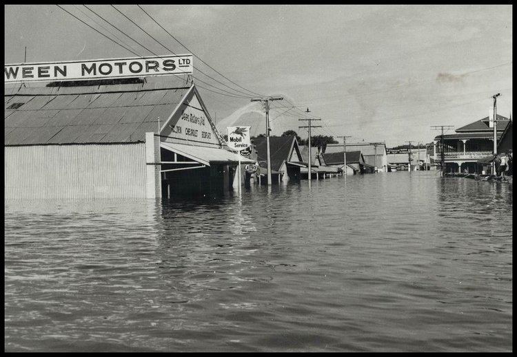
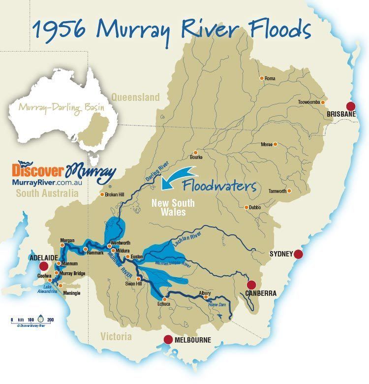
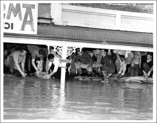
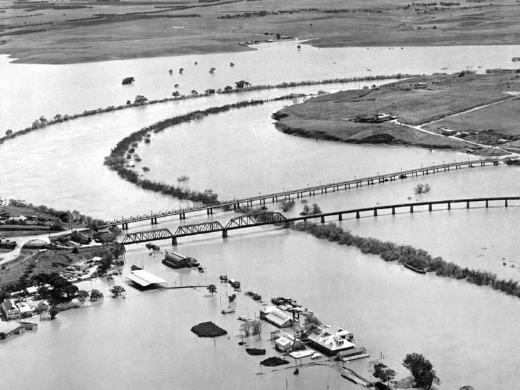
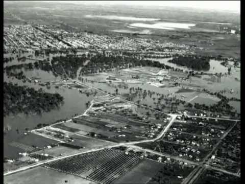
The 1956 Murray River flood involved the rising of waters in the Murray River and flooding of many towns in New South Wales, Victoria and South Australia. The flood occurred due to higher than average rainfalls in Western Queensland and heavy rains in the proceeding three months in the Murray-Darling basin. Flood waters moved down the Murray and Darling rivers for seven months and peaked between 11 and 14 August at Merbein in Victoria and 12.3 metres (40 ft) at Morgan in South Australia. Some areas were flooded up to 100 kilometres (62 mi) from the natural flow of the river. The flood was and still is considered the biggest flood in the recorded history of the Murray and described as "the greatest catastrophe in South Australia's history", in spite of no lives being lost.

Contents

1956 Murray River flood, in black and white has flooded street with electric post from left and right, a flood wall with tubes on top, in the middle is two boat with two person on each boat, from left, a man sitting on the boat rowing with both hands, has black hair, 2nd from left, a man sitting on the boat wearing a long sleeve and gray hat, 3rd a man standing, on a boat with his hand leaning in front panel wearing a black hat and long coat, 4th from left a man is standing, wearing a white hat and long coat, at the right is houses.

From upstream to downstream, flooding occurred in the towns of Wentworth in New South Wales; Colignan, Iraak, Mildura, Nangiloc, and Red Cliffs in Victoria; and Mannum, Murray Bridge, and Renmark to store high flows from the Darling River.

1956 Murray River flood map, with blue lines indicate the rivers from left, Murray River, Darling River, Lachan River, and blue areas indicates the area of floods, red dot indicates the city from left, Adelaide, Melbourne, Canberra, Sydney, Brisbane, Orange dot indicates towns, Goolwa, Meningie, Murray Bridge, Morgan, Manmum,  Renmar, Wentworth, Mildura, Euston, Swan Hill. Echuca, Aburry, Broken Hill, Dubbo, Bourke, Moree, Roma, Toowoomba.

Mildura 1956 murray river floods part 2


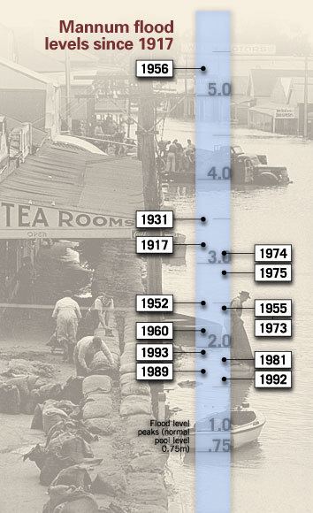
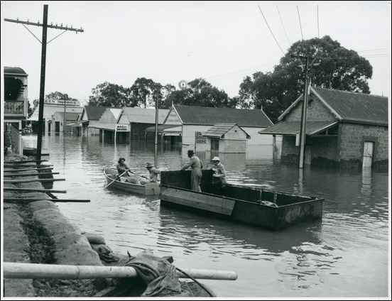
Mannum, South Australia

1956 Murray River flood, a group of people under a roof in a flooded street, from left a man is crouching with his left hand down to the water, has black hair wearing gray shirt and black pants, 2nd from left, a man leaning down with his hand holdinga bag from water, has black hair wearing a gray shirt and black pants, 3rd from left, a man crouching, holding a bag from the water, has black hair wearing a white long sleeve, and black pants, 4th from left a man is crouching, has black hair wearing a black long sleeve and gray pants with black shoes, 5th from left a man is smiling crouching, has black hair wearing black shirt, 6th from left a man is smiling, with a cigarette on his mouth has black hair wearing a gray shirt and black pants, 7th from left a man is smiling, crouching, has black hair wearing a black shirt, black pants and black boots, 8th from left, a kid is serious, standing leaning to his right knee with his right hand, has black hair, wearing a striped shirt, black shorts white socks and black shoes, 9th from left a man kneeling holding on the roof with both hands, wearing a white shirt and jacket, black pants, at the right is a man sitting with his knee up in front, has black hair wearing a black long sleeve and black pants with black shoes.

0 deaths, Hotels in the main street of Mannum operated their bars from the second floor with boats tying up to the balcony. The flood water broke the levee bank on 24 August, and had not fully receded until Christmas. To many locals it is common knowledge that the beginning of the roof on the Visitors' Centre in Main Street was the height in Main Street.

Mildura, Victoria

Aerial view of 1956 Murray River flood, has flooded street houses, trees and two Bridges in the middle.

In 2006, historic flood markers were erected at Apex Park and the lawns of the Mildura Rowing Club at Mildura, indicating the height the river reached in 1956. Additional markers are to be erected at various locations along the river from Wentworth to Colignan. Several towns in South Australia also have depth markers showing how high the floodwaters rose.

Wentworth, New South Wales

Aerial view of 1956 Murray River flood, has the town at the top with trees and rivers, at the bottom is a fields and towns, houses and roads.

The town of Wentworth, located on the junction of the Darling and Murray Rivers, erected a statue in 1959 in honour of the Fergie TE20 tractor, responsible for helping to erect a levee around the town which kept floodwaters at bay for months. A tractor rally is also held every five years to celebrate the Fergie.

At the top, Mannum Flood Levels since 1917, with a blue translucent line with numbers indicating water levels from .75, 1.0, 2.0, 3.0, 4.0, 5.0, and line with black dot indicating years. From 1917, 1931, 1952, 1955, 1956, 1960, 1973, 1974, 1975, 1981, 1989, 1992, 1993, from left to back is a group of people building a sack wall for floods, at the right is the flooded street area, has houses and boats,

References

1956 Murray River flood Wikipedia