
Location Vågå (Oppland) Surface area 4.83 km (1.86 sq mi) Surface elevation 953 m Mean depth 7 m | References NVE Area 4.83 km² Shore length 19.99 km | |
 | ||
Reference Norwegian Water Resources and Energy Directorate | ||
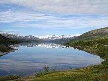
Øvre Sjodalsvatnet is a lake that is part of the river Sjoa in the municipality of Vågå in Oppland county, Norway.
Map of %C3%98vre Sjodalsvatnet, 2683 Tessanden, Norway
Near the top of the lake is Maurvangen campground and Bessheim mountain lodge.
Sjoa is a river that flows from the lake Gjende by Gjendesheim through Øvre Sjodalsvatnet, Nedre Sjodalsvatnet and the town of Sjoa in Gudbrandsdalen, where the river flows into Gudbrandsdalslågen.
Sjoa is a popular river for rafting and kayak trips. The river is also known for the tourist attraction Ridderspranget
References
Øvre Sjodalsvatnet Wikipedia(Text) CC BY-SA