
Airport type Public Elevation AMSL 103 ft / 31 m 5,000 1,524 Elevation 31 m | 11L/29R 5,000 Code TOA Phone +1 310-784-7900 | |
 | ||
Website www.ci.torrance.ca.us/... Address 3301 Airport Dr, Torrance, CA 90505, USA Similar Hawthorne Muni Airport, Los Angeles Internatio, Long Beach Airport, South Bay Aviation Inc, Pacific Skies Aviation | ||
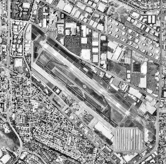
Landing zamperini field airport torrance
Zamperini Field (IATA: TOA, ICAO: KTOA, FAA LID: TOA) is a city-owned public airport three miles (5 km) southwest of downtown Torrance, in Los Angeles County, California, United States.
Contents
- Landing zamperini field airport torrance
- Diamond star da 40 flight to torrance airport zamperini field
- History
- Facilities and aircraft
- Terminal
- Helicopter operations
- Manufacturing
- Museum
- Accidents and incidents
- References
The airport is classified by the FAA as a Regional Reliever , and was once known as Torrance Municipal Airport, was renamed for local sports and war hero Louis Zamperini on December 7, 1946, the 5th anniversary of the attack on Pearl Harbor.
Diamond star da 40 flight to torrance airport zamperini field
History
The airport was completed by the United States Army Air Forces on 31 March 1943, and was known as Lomita Flight Strip. It was an emergency landing field for military aircraft on training flights. It was closed after World War II and the War Assets Administration (WAA) turned it over to local government. Once turned over to the City of Torrance it was renamed Zamperini Field on December 7, 1946.
Facilities and aircraft
Zamperini Field covers 506 acres (205 ha) and has two asphalt and concrete runways: 11L/29R, 5,000 x 150 ft (1,524 x 46 m) and 11R/29L, 3,000 x 75 ft (914 x 23 m). It has one asphalt helipad, 110 x 110 ft (34 x 34 m).
In the year ending May 31, 2005 the airport had 173,027 aircraft operations, an average of 474 per day: 99% general aviation, 1% military and <1% air taxi. 499 aircraft are based at this airport: 89% single-engine, 8% multi-engine, 2% helicopter and <1% glider.
Terminal
Zamperini Field has a small terminal with a vending machine, conference room, bathroom, and flight planning room. Outside a patio has small tables. Inside the terminal are historical papers related to the airport on the wall and a security post.
Helicopter operations
The helipad for a neighboring hospital, the Torrance Medical Center, is at the north-west corner of the airfield.
Manufacturing
Zamperini Field is the home of Robinson Helicopter Company. Their entire production, assembly, and testing facilities are on the southeast side of the airfield and are the largest buildings at the field.
Museum
Zamperini Field is the new home of the Western Museum of Flight, previously in Hawthorne, California.