
Population 12,417 (Jun 2014) Local time Sunday 2:33 PM | - Tree Japanese white pine Area 152.8 km² | |
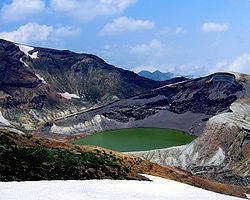 | ||
Weather 6°C, Wind W at 21 km/h, 59% Humidity Points of interest Okama, Togatta Hot Spring, Kami Hot Spring, Mahoroba Hot Spring, Kattamine Shrine | ||
Zaō (蔵王町, Zaō-machi) is a town located in Katta District, Miyagi Prefecture, Japan. As of June 2014, the town had an estimated population of 12,417 and a population density of 81.2 persons per km². The total area was 152.84 km².
Contents
- Map of Zao Katta District Miyagi Prefecture Japan
- Geography
- Neighboring municipalities
- History
- Economy
- Transportation
- Highway
- Local attractions
- References
Map of Zao, Katta District, Miyagi Prefecture, Japan
Geography
Zaō is located in southwestern Miyagi Prefecture in the Ou Mountains, bordered by Yamagata Prefecture to the west. Parts of the town are within the borders of Zaō Quasi-National Park and Zaō Kōgen Prefectural Natural Park.
Neighboring municipalities
History
The area of present-day Zaō was part of ancient Mutsu Province, and was made part Katta District in the new Iwaki Province at the start of the Meiji period. The district was transferred to Miyagi Prefecture on 21 August 1876.
The modern town of Zaō was established on April 1, 1955 by the merger of the villages of Enda and Miyamura, both from Katta District.
Economy
The economy of Zaō is largely based on agriculture and forestry and seasonal tourism.
Transportation
Zaō is not served by any rail lines.