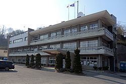
Area 78.38 km² Local time Wednesday 5:58 AM | Phone number 0224-83-2111 Population 11,366 (Sep 2015) | |
 | ||
Weather 3°C, Wind W at 26 km/h, 78% Humidity Points of interest Ryūtō-in Temple, Shionai Park, Shiroyama Park, Murata Dam | ||
Murata (村田町, Murata-machi) is a town located in Shibata District, Miyagi Prefecture, in the Tohoku region of northern Japan. As of September 2015, the town had an estimated population of 11,366 and a population density of 145 persons per km2. The total area was 78.38 square kilometres (30.26 sq mi).
Contents
- Map of Murata Shibata District Miyagi Prefecture Japan
- Geography
- Neighboring municipalities
- History
- Economy
- Education
- Railway
- Highway
- Sister city relations
- References
Map of Murata, Shibata District, Miyagi Prefecture, Japan
Geography
Murata is located in south-central Miyagi Prefecture. The Shiroishi River runs through the town.
Neighboring municipalities
History
The area of present-day Murata was part of ancient Mutsu Province. The modern village of Murata was established on April 1, 1889 with the creation of the municipalities system. It was promoted to town status on October 31, 1895. The town merged with the neighboring towns on Tomioka and Numabe on April 20, 1955.
Economy
The economy of Murata is largely based on agriculture.
Education
Murata has two elementary schools, two middle schools and one high school.
