
Elevation 6,635 m Prominence 2,028 m Listing Ultra-prominent peak | Easiest route glacier/snow/ice climb First ascent 1950 | |
 | ||
Similar Jirishanca, Siula Grande, Rondoy, Sarapo, Rasac | ||
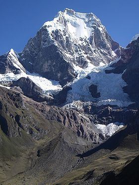
Yerupajá is a mountain of the Huayhuash mountain range in west central Peru, part of the Andes. At 6,635 metres (21,768 ft) (other sources: 6,617 m (21,709 ft)) it is the second-highest in Peru and the highest in the Waywash mountain range. The summit is the highest point in the Amazon River watershed, and was first reached in 1950 by Jim Maxwell and Dave Harrah, and its northern peak (Yerupajá Norte) in 1968 by the Wellingtonian Roger Bates and Graeme Dingle.
Contents
Map of Yerupaj%C3%A1, Peru
Many visitors consider Yerupajá to be the most spectacular peak in South America.
There have been only a few successful ascents of the peak because it is one of the hardest Andean high peaks to climb. The most popular route is the southwest face. The approach is normally made from Huaraz southwards via Chiquián and Jahuacocha.