
Peak Yerupajá State/Province Áncash, Huánuco, Lima Highest point Yerupajá | Length 30 km (19 mi) N-S Elevation 6,635 m | |
 | ||
Mountains | ||
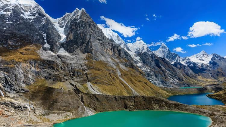
Jahuacocha lake and waterfall cordillera huayhuash peru
The Cordillera Huayhuash (possibly from Quechua waywash weasel) is a mountain range within the Andes of Peru, in the boundaries of the regions of Ancash, Lima and Huánuco. Since 2002 it is protected within the Cordillera Huayhuash Reserved Zone.
Contents
- Jahuacocha lake and waterfall cordillera huayhuash peru
- Map of Cordillera Huayhuash Peru
- Geography
- Peaks
- Trekking
- Safety
- References
Map of Cordillera Huayhuash, Peru
Geography
The Huayhuash range is 30 km long north to south and includes seven peaks over 6000 m including Yerupajá which, at 6,617 metres (21,709 ft), is the second highest peak in Peru. Another notable peak, Siula (6,344 m) was made famous by mountaineer Joe Simpson in his book Touching the Void. Unlike neighboring Cordillera Blanca, Huayhuash doesn't possess broad valleys and mountain passes are higher.
There are many lesser peaks surrounding those covered by ice, and several passes exceeding 5,000 m. It is necessary to travel a considerable distance from the central range to find ground lower than 3,000 m, even on valley floors, and the range is often taken to include this much larger area. The vegetated areas of the range are part of the Central Andean wet puna ecoregion
The area is barely populated at all, with what hamlets there are being very small and generally only found below 4000 m (the snowline is found at approximately 4,800 m). The nearest villages are Chiquián (3,400 m) and Cajatambo (3,375 m). Some mining takes place in the area, so to the north of the mountains there is an unsurfaced road leading up to as high as 4750 m. In 2002 the Peruvian Ministry of Agriculture declared the Huayhuash mountain range a "reserved zone" and prohibited certain economic activities, including any future mining.
Peaks
A selection of the highest peaks of the Huayhuash range is listed below.
Trekking
The range has become noted for trekking in the form of the Huayhuash Circuit which is considered quite a challenge and is undoubtedly far more demanding than the famous Inca Trail in the south of Peru. Fewer people trek the Cordillera Huayhuash than the nearby Cordillera Blanca. The circuit generally takes between ten and fourteen days, depending on the route taken.
Most of the walking and most of the campsites are above the 4,000 m tree line, so the landscape appears rugged and mountainous, affording views over very wide areas. The area is noted for its spectacular glacial lakes. Hot springs can also be found in the area, at Viconga Campsite precisely. Condors, llamas, alpacas and viscachas can be seen. Trekking is almost always undertaken in the dry winter months of May to September, and the cities Huaraz and Caraz over 100 & 167 km away are the usual choice for organizing and hiring camping a/o logistical support. Chiquián was the "Gateway to the Huayhuas" for a long time, but nowadays, daily buses (locally called colectivos) go deep into the mountains to the village Llamaq (3,300 m) and with private transport, as far as Cuartelwain camp, reached both by road built in the late 90s and 2000s, becoming now the new trail heads for starting/ending.
More challenging yet is the Alpine Circuit, which encircles the peaks at closer proximity. The Alpine Circuit involves some rock climbing and glacier travel, and takes 8–10 days to complete. This circuit can be arranged with reputable local hiking company Peru Bergsport in Huaraz
There are several lakes like Solteracoha (or Solterococha), Siula, Jahuacocha, Carhuacocha and Sarapococha.
Safety
Until the group's effective defeat in 1992 the Huayhuash range was used as a remote base by the Shining Path. On July 28, 1988, a group of Canadian and Peruvian climbers were held hostage for 12 hours after a failed assassination attempt on a group of military police. None of the climbers or police were hurt, though one Senderista was killed. In the late 1980s a party of European trekkers were robbed and ordered to return to Huaraz with the message that future intruders would be killed. The remains of a guerrilla camp can be seen near the lake Viconga.
Two foreign trekkers are known to have been murdered in Cajatambo in August 2002, though this is thought to have been motivated by robbery. Four hikers who resisted armed robbery were shot in 2004, one dying of blood loss before rescue. Since this last incident, the local communities began to charge a "protection" fee for passing in the private properties. Since then, the area is considered generally safe.
Near the north shore of the lake Viconga, the remains of an old Shining Path base camp can be still visited, including a shooting range, barracks and a training field.