
Population (2015) 1,863 Founded 1981 | Name meaning Dear, Darling | |
 | ||
Weather 12°C, Wind E at 5 km/h, 77% Humidity | ||
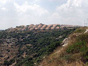
Yakir (Hebrew: יַקִּיר), is a communal Israeli settlement located in the West Bank's Samarian mountains about 35 km east of Tel Aviv near Revava and Nofim, on Road 5066 roughly between Barkan and Karnei Shomron. Founded in February 1981, it sits at 420 metres above sea level and is under the jurisdiction of Shomron Regional Council. In 2015 it had a population of 1,863.
Contents
Map of Yakir
The international community considers Israeli settlements in the West Bank illegal under international law, but the Israeli government disputes this.
Etymology
The name is taken from a passage in the Book of Jeremiah (31:20) 'Is Ephraim a darling (yaqir) son unto Me?'"
History
The settlement was established in 1981. As of 2013, property was being developed to accommodate a growing need for housing in the town.
In March 2013, the Biton's family car was attacked, near neighboring village of Kif el-Hares, with stones which caused it to get out of control and collide with a truck. Adele Biton was critically injured along with her mother and 2 sisters who were moderately injured. After almost two years in different hospitals and home care, she died on February 17, 2015.