
Area 5,640 km2 | ||
 | ||
Destinations Points of interest Church of the Nativity, Cave of the Patriarchs, Wadi Qelt, Mount Gerizim, Mamre | ||
GDP per capita 2,900.00 USD (2008) Gross domestic product 6.641 billion USD (2008) Population 1.715 million (Jun 2010) | ||
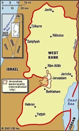
Map of West Bank
The West Bank (Arabic: الضفة الغربية aḍ-Ḍiffah l-Ġarbiyyah; Hebrew: הגדה המערבית, HaGadah HaMa'aravit) is a landlocked territory near the Mediterranean coast of Western Asia, the bulk of it now under Israeli control, or else under joint Israeli-Palestinian Authority control, and which final status of the entire area is yet to be determined by the parties concerned. The West Bank shares boundaries (demarcated by the Jordanian-Israeli armistice of 1949) to the west, north, and south with Israel, and to the east, across the Jordan River, with Jordan. The West Bank also contains a significant section of the western Dead Sea shore.
Contents
- Map of West Bank
- West bank story the musical full version
- A tour of the west bank palestine visiting bethlehem jericho and jordan river with abraham tours
- West Bank
- Cisjordan
- History
- 20th century
- Israeli Military Governorate and Civil Administration
- Legal status
- Political status
- Geography
- Climate
- Palestinian administration
- Areas annexed by Israel
- Israeli settlements
- Palestinian outposts
- West Bank barrier
- Administrative divisions
- Crossing points
- Economy
- Economic consequences
- Water supply
- Demographics
- Major population centers
- Religion
- Roads
- Airports
- Telecom
- Radio and television
- Higher education
- Bethlehem street food shawarma wrap west bank
- References
The West Bank, including East Jerusalem, has a land area of 5,640 km2 plus a water area of 220 km2, consisting of the northwest quarter of the Dead Sea. As of July 2015 it has an estimated population of 2,785,366 Palestinians, and approximately 371,000 Israeli settlers, and approximately another 212,000 Jewish Israelis in East Jerusalem. The international community considers Israeli settlements in the West Bank, including East Jerusalem, illegal under international law, though Israel disputes this. The International Court of Justice advisory ruling (2004) concluded that events that came after the 1967 occupation of the West Bank by Israel, including the Jerusalem Law, Israel's peace treaty with Jordan and the Oslo Accords, did not change the status of the West Bank (including East Jerusalem) as occupied territory with Israel as the occupying power.
West bank story the musical full version
A tour of the west bank palestine visiting bethlehem jericho and jordan river with abraham tours
West Bank

The name West Bank is a translation of the Arabic term ad-Diffah I-Garbiyyah, given to the territory west of the Jordan River that fell, in 1948, under occupation and administration by Jordan, which claimed subsequently to have annexed it in 1950. This annexation was recognized only by Britain, Iraq and Pakistan. The term was chosen to differentiate the west bank of the River Jordan from the "east bank" of this river.
Cisjordan
The neo-Latin name Cisjordan or Cis-Jordan (literally "on this side of the River Jordan") is the usual name for the territory in the Romance languages and Hungarian. The name West Bank, however, has become the standard usage for this geopolitical entity in English and some of the other Germanic languages since its creation following the Jordanian army's conquest.
In English, the name Cisjordan is occasionally used to designate the entire region between the Jordan River and the Mediterranean, particularly in the historical context of the British Mandate and earlier times. The analogous Transjordan (literally "on the other side of the River Jordan") has historically been used to designate the region now roughly comprising the state of Jordan, which lies to the east of the Jordan River.
History
From 1517 through 1917, the area now known as the West Bank was under Ottoman rule as part of the provinces of Syria.
20th century
At the 1920 San Remo conference, the victorious Allied powers (France, UK, USA, etc.) allocated the area to the British Mandate of Palestine (1920–47). The San Remo Resolution adopted on 25 April 1920 incorporated the Balfour Declaration of 1917. It and Article 22 of the Covenant of the League of Nations were the basic documents upon which the British Mandate for Palestine was constructed. Faced with the determination of Emir Abdullah to unify Arab lands under the Hashemite banner, the British proclaimed Abdullah ruler of the three districts, known collectively as Transjordan. Confident that his plans for the unity of the Arab nation would eventually come to fruition, the emir established the first centralized governmental system in what is now modern Jordan on 11 April 1921. The West Bank area, was conquered by Jordan during the 1948 war with the new state of Israel.
In 1947, it was subsequently designated as part of a proposed Arab state by the United Nations (UN) partition plan for Palestine. The resolution recommended partition of the British Mandate into a Jewish State, an Arab State, and an internationally administered enclave of Jerusalem; a broader region of the modern-day West Bank was assigned to the Arab State. The resolution designated the territory described as "the hill country of Samaria and Judea" (including what is now also known as the "West Bank") as part of the proposed Arab state, but following the 1948 Arab-Israeli War this area was captured by Transjordan (renamed Jordan two years after independence in 1946).
1949 Armistice Agreements defined the interim boundary between Israel and Jordan. In 1950, Transjordan annexed the area west of the Jordan River, naming it "West Bank" or "Cisjordan", as "East Bank" or "Transjordan" designated the area east of the river. Jordan ruled over the West Bank from 1948 until 1967. Jordan's annexation was never formally recognized by the international community, with the exception of the United Kingdom. A two-state option, dividing Palestine, as opposed to a binary solution arose during the period of the British mandate in the area.The United Nations Partition Plan had envisaged two states, one Jewish and the other Arab/Palestinian, but in the wake of the war only one emerged at the time. King Abdullah of Jordan had been crowned King of Jerusalem by the Coptic Bishop on 15 November 1948. and granted Palestinian Arabs in the West Bank and East Jerusalem Jordanian citizenship.
Israeli Military Governorate and Civil Administration
In June 1967, the West Bank and East Jerusalem were captured by Israel as a result of the Six-Day War. With the exception of East Jerusalem and the former Israeli-Jordanian no man's land, the West Bank was not annexed by Israel but came under Israeli military control until 1982.
Although the 1974 Arab League summit resolution at Rabat designated the Palestinian Liberation Organization (PLO) as the "sole legitimate representative of the Palestinian people", Jordan did not officially relinquish its claim to the area until 1988, when it severed all administrative and legal ties with the West Bank and eventually stripped West Bank Palestinians of Jordanian citizenship.
In 1982, as a result of the Israeli–Egyptian peace treaty, the direct military rule was transformed into a semi-civil authority, operating directly under the Israeli Ministry of Defense, thus taking control of civil matters of Palestinians from the IDF to civil servants in the Ministry of Defense. The Israeli settlements were, on the other hand, administered subsequently as Judea and Samaria Area directly by Israel.
Since the 1993 Oslo Accords, the Palestinian Authority officially controls a geographically non-contiguous territory comprising approx. 11% of the West Bank (known as Area A) which remains subject to Israeli incursions. Area B (approx. 28%) is subject to joint Israeli-Palestinian military and Palestinian civil control. Area C (approx. 61%) is under full Israeli control. Though 164 nations refer to the West Bank, including East Jerusalem, as "Occupied Palestinian Territory", the state of Israel is of the view that only territories captured in war from "an established and recognized sovereign" are considered occupied territories. After the 2007 split between Fatah and Hamas, the West Bank areas under Palestinian control are an exclusive part of the Palestinian Authority, while the Gaza Strip is ruled by Hamas.
Legal status
From 1517 to 1917 the West Bank was part of the Ottoman Empire. Turkey, successor state to the Ottoman Empire, renounced its territorial claims in 1923, signing the Treaty of Lausanne, and the area now called the West Bank became an integral part of the British Mandate for Palestine. During the Mandate period Britain had no right of sovereignty, which was held by the people under the mandate. Nevertheless, Britain, as custodians of the land, implemented the land tenure laws in Palestine, which it had inherited from the Ottoman Turks (as defined in the Ottoman Land Code of 1858), applying these laws unto, both, Arab and Jewish legal tenants or otherwise. In 1947 the UN General Assembly recommended that the area that became the West Bank become part of a future Arab state, but this proposal was opposed by the Arab states at the time. In 1948, Jordan occupied the West Bank and annexed it in 1950.
In 1967, Israel captured the West Bank from Jordan in the Six-Day War. UN Security Council Resolution 242 that followed called for withdrawal from territories occupied in the conflict in exchange for peace and mutual recognition. Since 1979 the United Nations Security Council, the United Nations General Assembly, the United States, the EU, the International Court of Justice, and the International Committee of the Red Cross refer to the West Bank, including East Jerusalem, as occupied Palestinian territory or the occupied territories. General Assembly resolution 58/292 (17 May 2004) affirmed that the Palestinian people have the right to sovereignty over the area.
The International Court of Justice and the Supreme Court of Israel have ruled that the status of the West Bank is that of military occupation. In its 2004 advisory opinion the International Court of Justice concluded that:
The territories situated between the Green Line and the former eastern boundary of Palestine under the Mandate were occupied by Israel in 1967 during the armed conflict between Israel and Jordan. Under customary international law, the Court observes, these were therefore occupied territories in which Israel had the status of occupying Power. Subsequent events in these territories have done nothing to alter this situation. The Court concludes that all these territories (including East Jerusalem) remain occupied territories and that Israel has continued to have the status of occupying Power.
In the same vein the Israeli Supreme Court stated in the 2004 Beit Sourik case that:
The general point of departure of all parties – which is also our point of departure – is that Israel holds the area in belligerent occupation (occupatio bellica)......The authority of the military commander flows from the provisions of public international law regarding belligerent occupation. These rules are established principally in the Regulations Concerning the Laws and Customs of War on Land, The Hague, 18 October 1907 [hereinafter – the Hague Regulations]. These regulations reflect customary international law. The military commander’s authority is also anchored in IV Geneva Convention Relative to the Protection of Civilian Persons in Time of War 1949.
The executive branch of the Israeli government, through the Ministry of Foreign Affairs, has defined the West Bank as disputed territory, whose status can only be determined through negotiations. The Ministry says that occupied territories are territories captured in war from an established and recognized sovereign, and that since the West Bank wasn't under the legitimate and recognized sovereignty of any state prior to the Six-Day War, it shouldn't be considered an occupied territory.
The International Court of Justice ruling of 9 July 2004, however, found that the West Bank, including East Jerusalem, is territory held by Israel under military occupation, regardless of its status prior to it coming under Israeli occupation and the Fourth Geneva convention applies de jure. The international community regards the West Bank (including East Jerusalem) as territories occupied by Israel.
International law (Article 49 of the Fourth Geneva Convention) prohibits "transfers of the population of an occupying power to occupied territories", incurring a responsibility on the part of Israel's government to not settle Israeli citizens in the West Bank.
As of 27 September 2013, 134 (69.4%) of the 193 member states of the United Nations have recognised the State of Palestine within the Palestinian territories, which are recognized by Israel to constitute a single territorial unit, and of which the West Bank is the core of the would-be state.
Political status
The future status of the West Bank, together with the Gaza Strip on the Mediterranean shore, has been the subject of negotiation between the Palestinians and Israelis, although the current Road Map for Peace, proposed by the "Quartet" comprising the United States, Russia, the European Union, and the United Nations, envisions an independent Palestinian state in these territories living side by side with Israel (see also proposals for a Palestinian state). However, the "Road Map" states that in the first phase, Palestinians must end all attacks on Israel, whereas Israel must dismantle outposts. Since neither condition has been met since the Road Map was "accepted" by all sides, final negotiations have not yet begun on major political differences.
The Palestinian Authority believes that the West Bank ought to be a part of their sovereign nation, and that the presence of Israeli military control is a violation of their right to Palestinian Authority rule. The United Nations calls the West Bank and Gaza Strip Israeli-occupied territories. The United States State Department also refers to the territories as occupied. Many Israelis and their supporters prefer the term disputed territories, because they claim part of the territory for themselves, and state that the land has not for 2000 years been sovereign.
Palestinian public opinion opposes Israeli military and settler presence on the West Bank as a violation of their right to statehood and sovereignty. Israeli opinion is split into a number of views:
In 2005 the United States ambassador to Israel, Daniel C. Kurtzer, expressed U.S. support "for the retention by Israel of major Israeli population centres [in the West Bank] as an outcome of negotiations", reflecting President Bush's statement a year earlier that a permanent peace treaty would have to reflect "demographic realities" on the West Bank. In May 2011 US President Barack Obama officially stated US support for a future Palestinian state based on borders prior to the 1967 War, allowing for land swaps where they are mutually agreeable between the two sides. Obama was the first US president to formally support the policy, but he stated that it had been one long held by the US in its Middle East negotiations.
Geography
The West Bank has an area of 5,628 square kilometres (2,173 sq mi), which comprises 21.2% of former Mandatory Palestine (excluding Jordan) and has generally rugged mountainous terrain. The total length of the land boundaries of the region are 404 kilometres (251 miles). The terrain is mostly rugged dissected upland, some vegetation in the west, but somewhat barren in the east. The elevation span between the shoreline of the Dead Sea at −408 m to the highest point at Mount Nabi Yunis, at 1,030 m (3,379 ft) above sea level. The area of West Bank is landlocked; highlands are main recharge area for Israel's coastal aquifers.
There are few natural resources in the area except the highly arable land, which comprises 27% of the land area of the region. It is mostly used as permanent pastures (32% of arable land) and seasonal agricultural uses (40%). Forests and woodland comprise just 1%, with no permanent crops.
Climate
The climate in the West Bank is mostly Mediterranean, slightly cooler at elevated areas compared with the shoreline, west to the area. In the east, the West Bank includes the Judean Desert and the shoreline of the Dead Sea – both with dry and hot climate.
Palestinian administration
The 1993 Oslo Accords declared the final status of the West Bank to be subject to a forthcoming settlement between Israel and the Palestinian leadership. Following these interim accords, Israel withdrew its military rule from some parts of the West Bank, which was divided into three administrative divisions of the Oslo Accords:
Area A, 2.7%, full civil control of the Palestinian Authority, comprises Palestinian towns, and some rural areas away from Israeli settlements in the north (between Jenin, Nablus, Tubas, and Tulkarm), the south (around Hebron), and one in the center south of Salfit. Area B, 25.2%, adds other populated rural areas, many closer to the center of the West Bank. Area C contains all the Israeli settlements (excluding settlements in East Jerusalem), roads used to access the settlements, buffer zones (near settlements, roads, strategic areas, and Israel), and almost all of the Jordan Valley and the Judean Desert.
Areas A and B are themselves divided among 227 separate areas (199 of which are smaller than 2 square kilometers (1 sq mi)) that are separated from one another by Israeli-controlled Area C. Areas A, B, and C cross the 11 governorates used as administrative divisions by the Palestinian National Authority, Israel, and the IDF and named after major cities. The mainly open areas of Area C, which contains all of the basic resources of arable and building land, water springs, quarries and sites of touristic value needed to develop a viable Palestinian state, were to be handed over to the Palestinians by 1999 under the Oslo Accords as part of a final status agreement. This agreement was never achieved.
According to B'tselem, while the vast majority of the Palestinian population lives in areas A and B, the vacant land available for construction in dozens of villages and towns across the West Bank is situated on the margins of the communities and defined as area C. Less than 1% of area C is designated for use by Palestinians, who are also unable to legally build in their own existing villages in area C due to Israeli authorities' restrictions,
An assessment by the UN Office for the Coordination of Humanitarian Affairs in 2007 found that approximately 40% of the West Bank was taken up by Israeli infrastructure. The infrastructure, consisting of settlements, the barrier, military bases and closed military areas, Israeli declared nature reserves and the roads that accompany them is off-limits or tightly controlled to Palestinians.
In June 2011, the Independent Commission for Human Rights published a report that found that Palestinians in the West Bank and the Gaza Strip were subjected in 2010 to an "almost systematic campaign" of human rights abuse by the Palestinian Authority and Hamas, as well as by Israeli authorities, with the security forces of the PA and Hamas being responsible for torture, arrests and arbitrary detentions.
Areas annexed by Israel
Through the Jerusalem Law, Israel extended its administrative control over East Jerusalem. This has often been interpreted as tantamount to an official annexation, though Ian Lustick, in reviewing the legal status of Israeli measures, has argued that no such annexation ever took place. The Palestinian residents have legal permanent residency status. Rejecting the Jerusalem Law, the UN Security Council passed UN Security Council Resolution 478, declaring that the law was "null and void". Although permanent residents are permitted, if they wish, to receive Israeli citizenship if they meet certain conditions including swearing allegiance to the State and renouncing any other citizenship, most Palestinians did not apply for Israeli citizenship for political reasons. There are various possible reasons as to why the West Bank had not been annexed to Israel after its capture in 1967. The government of Israel has not formally confirmed an official reason; however, historians and analysts have established a variety of such, most of them demographic. Among those most commonly cited have been:
The importance of demographic concerns to some significant figures in Israel's leadership was illustrated when Avraham Burg, a former Knesset Speaker and former chair of the Jewish Agency for Israel, wrote in The Guardian in September 2003,
"Between the Jordan and the Mediterranean there is no longer a clear Jewish majority. And so, fellow citizens, it is not possible to keep the whole thing without paying a price. We cannot keep a Palestinian majority under an Israeli boot and at the same time think ourselves the only democracy in the Middle East. There cannot be democracy without equal rights for all who live here, Arab as well as Jew. We cannot keep the territories and preserve a Jewish majority in the world's only Jewish state – not by means that are humane and moral and Jewish."Israeli settlements
As of December 2010, 327,750 Israelis live in the 121 settlements in the West Bank officially recognised by the Israeli government, 192,000 Israelis live in settlements in East Jerusalem. There are approximately 100 further settlement outposts which are not officially recognized by the Israeli government and are illegal under Israeli law, but have been provided with infrastructure, water, sewage, and other services by the authorities.
The international consensus is that all Israeli settlements on the West Bank beyond the Green Line are illegal under international law. In particular, the European Union as a whole considers the settlements to be illegal. Significant portions of the Israeli public similarly oppose the continuing presence of Jewish Israelis in the West Bank and have supported the 2005 settlement relocation. The majority of legal scholars also hold the settlements to violate international law, however individuals including Julius Stone, and Eugene Rostow have argued that they are legal under international law, on a number of different grounds. Immediately after the 1967 war Theodor Meron, legal counsel of Israel's Foreign Ministry advised Israeli ministers in a "top secret" memo that any policy of building settlements across occupied territories violated international law and would "contravene the explicit provisions of the Fourth Geneva Convention".
The UN Security Council has issued several non-binding resolutions addressing the issue of the settlements. Typical of these is UN Security Council resolution 446 which states [the] practices of Israel in establishing settlements in the Palestinian and other Arab territories occupied since 1967 have no legal validity, and it calls on Israel as the occupying Power, to abide scrupulously by the 1949 Fourth Geneva Convention.
The Conference of High Contracting Parties to the Fourth Geneva Convention held in Geneva on 5 December 2001 called upon "the Occupying Power to fully and effectively respect the Fourth Geneva Convention in the Occupied Palestinian Territory, including East Jerusalem, and to refrain from perpetrating any violation of the Convention." The High Contracting Parties reaffirmed "the illegality of the settlements in the said territories and of the extension thereof."
On 30 December 2007, Israeli Prime Minister Ehud Olmert issued an order requiring approval by both the Israeli Prime Minister and Israeli Defense Minister of all settlement activities (including planning) in the West Bank. The change had little effect with settlements continuing to expand, and new ones being established. On 31 August 2014, Israel announced it was appropriating 400 hectares of land in the West Bank to eventually house 1,000 Israel families. The appropriation was described as the largest in more than 30 years. According to reports on Israel Radio, the development is a response to the 2014 kidnapping and murder of Israeli teenagers.
Palestinian outposts
The Haaretz published an article in December 2005 about demolition of "Palestinian outposts" in Bil'in, the demolitions sparked a political debate as according to PeaceNow it was a double standard ("After what happened today in Bil'in, there is no reason that the state should defend its decision to continue the construction" credited to Michael Sfard).
In January 2012, the European Union approved the "Area C and Palestinian state building" report. The report said Palestinian presence in Area C has been continuously undermined by Israel and that state building efforts in Area C of the Palestinian Authority (PA) and the EU were of "utmost importance in order to support the creation of a contiguous and viable Palestinian state". The EU will support various projects to "support the Palestinian people and help maintain their presence".
In May 2012, a petition was filed to the Israeli Supreme Court about the legality of more 15 Palestinian outposts and Palestinian building in "Area C". The cases were filed by Regavim.
The petition was one of 30 different petitions with the common ground of illegal land takeover and illegal construction and use of natural resources. Some of the petitions (27) had been set for trials and the majority received a verdict.
Ynet News stated on 11 January 2013 that a group of 200 Palestinians with unknown number of foreign activists created an outpost named Bab al-Shams ("Gate of the Sun"), contains 50 tents
Ynet News stated on 18 January 2013 that Palestinian activists built an outpost on a disputed area in Beit Iksa, where Israel plans to construct part of the separation fence in the Jerusalem vicinity while the Palestinians claim that the area belongs to the residents of Beit Iksa. named Bab al-Krama
West Bank barrier
The Israeli West Bank barrier is a physical barrier ordered for construction by the Israeli Government, consisting of a network of fences with vehicle-barrier trenches surrounded by an on average 60 meters (197 ft) wide exclusion area (90%) and up to 8 meters (26 ft) high concrete walls (10%) (although in most areas the wall is not nearly that high). It is located mainly within the West Bank, partly along the 1949 Armistice line, or "Green Line" between the West Bank and Israel. As of April 2006 the length of the barrier as approved by the Israeli government is 703 kilometers (437 mi) long. Approximately 58.4% has been constructed, 8.96% is under construction, and construction has not yet begun on 33% of the barrier. The space between the barrier and the green line is a closed military zone known as the Seam Zone, cutting off 8.5% of the West Bank and encompassing dozens of villages and tens of thousands of Palestinians.
The barrier generally runs along or near the 1949 Jordanian-Israeli armistice/Green Line, but diverges in many places to include on the Israeli side several of the highly populated areas of Jewish settlements in the West Bank such as East Jerusalem, Ariel, Gush Etzion, Immanuel, Karnei Shomron, Givat Ze'ev, Oranit, and Maale Adumim.
Supporters of the barrier claim it is necessary for protecting Israeli civilians from Palestinian attacks, which increased significantly during the Al-Aqsa Intifada; it has helped reduce incidents of terrorism by 90% from 2002 to 2005; over a 96% reduction in terror attacks in the six years ending in 2007, though Israel's State Comptroller has acknowledged that most of the suicide bombers crossed into Israel through existing checkpoints. Its supporters claim that the onus is now on the Palestinian Authority to fight terrorism.
Opponents claim the barrier is an illegal attempt to annex Palestinian land under the guise of security, violates international law, has the intent or effect to pre-empt final status negotiations, and severely restricts Palestinian livelihoods, particularly limiting their freedom of movement within and from the West Bank thereby undermining their economy.
Administrative divisions
Palestinian governorates
After the signing of the Oslo Accords, the West Bank was divided into 11 governorates under the jurisdiction of the Palestinian National Authority. Since 2007 there are two governments claiming to be the legitimate government of the Palestinian National Authority, one based in the West Bank and one based in the Gaza Strip.
Israeli administrative districts
The West Bank is further divided into 8 administrative regions: Menashe (Jenin area), HaBik'a (Jordan Valley), Shomron (Shechem area, known in Arabic as Nablus), Efrayim (Tulkarm area), Binyamin (Ramallah/al-Bireh area), Maccabim (Maccabim area), Etzion (Bethlehem area) and Yehuda (Hebron area).
Crossing points
Allenby Bridge, or ‘King Hussein Bridge’, is the main port for the Palestinian in the West Bank to the Jordanian borders. This crossing point is controlled by Israel since 1967. It was inaugurated on 11 December 2011 under the military order "175" entitled ‘An order concerning transition station’. Later, Order ‘446’ was issued which annexed the Damia Bridge crossing point to the Allenby Bridge as a commercial crossing point only. Goods were exported to Jordan, while the import was banned for security purposes.
In 1993, the Palestinian National Authority, according to Oslo Accord assigned by PLO and the Israeli government, became a partial supervisor over the Rafah Border Crossing to Gaza Strip. The Palestinian Authority was responsible for issuing passports to Palestinians in the West Bank and Gaza Strip. However, Israel remained the major responsible party for this crossing point. According to the agreement, Israel has the right to independently inspect luggage and to maintain security. In addition, it can prevent anyone from using the crossing.
Economy
As of the early-21st century, the economy of the Palestinian territories is chronically depressed, with unemployment rates constantly over 20% since 2000 (19% in the West Bank in first half of 2013).
Economic consequences
According to the World Bank, the main reason for economic depression is the Israeli occupation.
According to a 2007 World Bank report, the Israeli occupation of the West Bank has destroyed the Palestinian economy, in violation of the 2005 Agreement on Movement and Access. All major roads (with a total length of 700 km) are basically off-limits to Palestinians, making it impossible to do normal business. Economic recovery would reduce Palestinian dependence on international aid by one billion dollars per year.
A more comprehensive 2013 World Bank report calculates that, if the Interim Agreement was respected and restrictions lifted, a few key industries alone would produce USD 2.2 billion per annum more (or 23% of 2011 Palestinian GDP) and reduce by some USD 800 million (50%) the Palestinian Authority's deficit; the employment would increase by 35%.
In August 2014, Palestinian leaders said they would apply to the United Nations Security Council for the establishment of a timetable for ending the Israeli occupation. The application would be made on 15 September 2014, following an Arab League meeting on 5 September 2014 at which support for the move would be requested. Unless a timetable was established, the Palestinian leadership said it would apply to the International Criminal Court where it would hold Israel responsible for its actions not only in the West Bank, but also in the Gaza Strip.
Water supply
Amnesty International has criticized the way that the Israeli state is dealing with the regional water resources:
Palestinians in the Occupied Palestinian Territories (OPT) do not have access to adequate, safe water supplies...Discriminatory Israeli policies in the OPT are the root cause of the striking disparity in access to water between Palestinians and Israelis...The inequality is even more pronounced between Palestinian communities and unlawful Israeli settlements, established in the OPT in violation of international law. Swimming pools, well-watered lawns and large irrigated farms in Israeli settlements in the OPT stand in stark contrast next to Palestinian villages whose inhabitants struggle even to meet their essential domestic water needs. In parts of the West Bank, Israeli settlers use up to 20 times more water per capita than neighbouring Palestinian communities, who survive on barely 20 litres of water per capita a day– the minimum amount recommended by the WHO for emergency situations response.
Demographics
In December 2007, an official census conducted by the Palestinian Authority found that the Palestinian Arab population of the West Bank (including East Jerusalem) was 2,345,000. However, the World Bank and American-Israeli Demographic Research Group identified a 32% discrepancy between first-grade enrollment statistics documented by the Palestinian Ministry of Education and Palestinian Central Bureau of Statistics (PCBS)’ 2007 projections, with questions also raised about the PCBS’ growth assumptions for the period 1997–2003. The Israeli Civil Administration put the number of Palestinians in the West Bank at 2,657,029 as of May 2012.
There are 389,250 Israeli settlers living in the West Bank excluding East Jerusalem, as well as around 375,000 living in Israeli-annexed East Jerusalem. There are also small ethnic groups, such as the Samaritans living in and around Nablus, numbering in the hundreds.
As of October 2007, around 23,000 Palestinians in the West Bank worked in Israel every day, while another 9,200 worked in Israeli settlements. In addition, around 10,000 Palestinian traders from the West Bank were allowed to travel every day into Israel. By 2014, 92,000 Palestinians worked in Israel legally or illegally, twice as many as in 2010.
In 2008, approximately 30% of Palestinians or 754,263 persons living in the West Bank were refugees or descendants of refugees from villages and towns located in what became Israel during the 1948 Arab-Israeli War, according to UNRWA statistics. A 2011 EU report titled "Area C and Palestinian State Building" reported that before the Israeli occupation in 1967, between 200,000 and 320,000 Palestinians used to live in the Jordan Valley, 90% which is in Area C, but demolition of Palestinian homes and prevention of new buildings has seen the number drop to 56,000, 70% of which live in Area A, in Jericho. In a similar period, the Jewish population in Area C has grown from 1,200 to 310,000.
Major population centers
The most densely populated part of the region is a mountainous spine, running north-south, where the cities of Jerusalem, Nablus, Ramallah, al-Bireh, Jenin, Bethlehem, Hebron and Yattah are located as well as the Israeli settlements of Ariel, Ma'ale Adumim and Beitar Illit. Ramallah, although relatively mid in population compared to other major cities as Hebron, Nablus and Jenin, serves as an economic and political center for the Palestinians. Near Ramallah the new city of Rawabi is under construction. Jenin in the extreme north and is the capital of north of the West Bank and is on the southern edge of the Jezreel Valley. Modi'in Illit, Qalqilyah and Tulkarm are in the low foothills adjacent to the Israeli Coastal Plain, and Jericho and Tubas are situated in the Jordan Valley, north of the Dead Sea.
Religion
The population of the West Bank is 80–85% Muslim (mostly Sunni) and 12–14% Jewish. The remainder are Christian (mostly Greek Orthodox) and others.
Roads
In 2010, the West Bank and Gaza Strip together had 4,686 km (2,912 mi) of roadways.
Transportation infrastructure is particularly problematic as Palestinian use of roads in Area C is highly restricted, and travel times can be inordinate; the Palestinian Authority has also been unable to develop roads, airports or railways in or through Area C, while many other roads were restricted only to public transportation and to Palestinians who have special permits from Israeli authorities.
At certain times, Israel maintained more than 600 checkpoints or roadblocks in the region. As such, movement restrictions were also placed on main roads traditionally used by Palestinians to travel between cities, and such restrictions are still blamed for poverty and economic depression in the West Bank. Underpasses and bridges (28 of which have been constructed and 16 of which are planned) link Palestinian areas separated from each other by Israeli settlements and bypass roads"
Israeli restrictions were tightened in 2007.
As of August 2007, a divided highway is currently under construction that will pass through the West Bank. The highway has a concrete wall dividing the two sides, one designated for Israeli vehicles, the other for Palestinian. The wall is designed to allow Palestinians to pass north-south through Israeli-held land and facilitate the building of additional Jewish settlements in the Jerusalem neighborhood.
As of February 2012, a plan for 475-kilometer rail network, establishing 11 new rail lines in West Bank, was confirmed by Israeli Transportation Ministry. The West Bank network would include one line running through Jenin, Nablus, Ramallah, Jerusalem, Ma'aleh Adumim, Bethlehem and Hebron. Another would provide service along the Jordanian border from Eilat to the Dead Sea, Jericho and Beit She'an and from there toward Haifa in the west and in also in a northeasterly direction. The proposed scheme also calls for shorter routes, such as between Nablus and Tul Karm in the West Bank, and from Ramallah to the Allenby Bridge crossing into Jordan.
Airports
The only airport in the West Bank is the Atarot Airport near Ramallah, but it has been closed since 2001.
Telecom
The Palestinian Paltel telecommunication companies provide communication services such as landline, cellular network and Internet in the West Bank and Gaza Strip. Dialling code +970 is used in the West Bank and all over the Palestinian territories. Until 2007, the Palestinian mobile market was monopolized by Jawwal. A new mobile operator for the territories launched in 2009 under the name of Wataniya Telecom. The number of Internet users increased from 35,000 in 2000 to 356,000 in 2010.
Radio and television
The Palestinian Broadcasting Corporation broadcasts from an AM station in Ramallah on 675 kHz; numerous local privately owned stations are also in operation. Most Palestinian households have a radio and TV, and satellite dishes for receiving international coverage are widespread. Recently, PalTel announced and has begun implementing an initiative to provide ADSL broadband internet service to all households and businesses. Israel's cable television company HOT, satellite television provider (DBS) Yes, AM and FM radio broadcast stations and public television broadcast stations all operate. Broadband internet service by Bezeq's ADSL and by the cable company are available as well. The Al-Aqsa Voice broadcasts from Dabas Mall in Tulkarem at 106.7 FM. The Al-Aqsa TV station shares these offices.
Higher education
Seven universities are operating in the West Bank:
Most universities in the West Bank have politically active student bodies, and elections of student council officers are normally along party affiliations. Although the establishment of the universities was initially allowed by the Israeli authorities, some were sporadically ordered closed by the Israeli Civil Administration during the 1970s and 1980s to prevent political activities and violence against the IDF. Some universities remained closed by military order for extended periods during years immediately preceding and following the first Palestinian Intifada, but have largely remained open since the signing of the Oslo Accords despite the advent of the Al-Aqsa Intifada (Second Intifada) in 2000.
The founding of Palestinian universities has greatly increased education levels among the population in the West Bank. According to a Birzeit University study, the percentage of Palestinians choosing local universities as opposed to foreign institutions has been steadily increasing; as of 1997, 41% of Palestinians with bachelor's degrees had obtained them from Palestinian institutions. According to UNESCO, Palestinians are one of the most highly educated groups in the Middle East "despite often difficult circumstances". The literacy rate among Palestinians in the West Bank and the Gaza Strip according to the Palestinian Central Bureau of Statistics (PCBS) is 94.6% for 2009.