
Length 346 km | ||
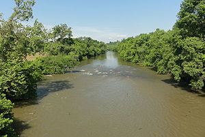 | ||
The Yadkin River is one of the longest rivers in North Carolina, flowing 215 miles (346 km). It rises in the northwestern portion of the state near the Blue Ridge Parkway's Thunder Hill Overlook. Several parts of the river are impounded by dams for water, power, and flood control. The river becomes the Pee Dee River at the confluence of the Uwharrie River south of the community of Badin, NC and east of the town of Albemarle, NC. The river flows into South Carolina near Cheraw, which is at the fall line. The entirety of the Yadkin River and the Great Pee Dee River is part of the Yadkin-Pee Dee River Basin.
Contents
- Map of Yadkin River North Carolina USA
- Gopro yadkin river kayak nc
- Lakes created by the YadkinPee Dee RiverEdit
- List of crossingsEdit
- References
Map of Yadkin River, North Carolina, USA
Prior to the arrival of Europeans, the Yadkin basin was inhabited by Siouan-speaking tribes. The Saura and Tutelo tribes are mentioned in historic records of the area. Before the Revolutionary War, colonial settlers of primarily Scots-Irish, German, and English extraction migrated into the Yadkin basin from Virginia and Pennsylvania using the Great Wagon Road and the Carolina Road. Notably, these included Moravian colonists from Bethlehem, Pennsylvania who occupied the 100,000-acre Wachovia tract following its purchase in 1753 (See also Old Salem).
In 1859 the NC Supreme court noted "it is certain that the Yadkin river is capable of private ownership and that some parts of the riverbed have been granted to private individuals." State v. Glen 52 N.C. 321( 1956). The court determined that the owners of the dam across the Yadkin could not have his property taken without just compensation.
The river is extensively used for recreation. Fishing consists mostly of sunfish, catfish, largemouth bass and white bass in the spring and early summer. Canoeing and rafting are also possible. A portion of the river flows through Pilot Mountain State Park. Morrow Mountain State Park and the Uwharrie National Forest are along the banks of the river where the river's name changes to the Pee Dee River.
In 1987, the NC General Assembly established the Yadkin River State Trail as a blueway which follows the river for 130 miles. The paddle trail is a part of North Carolina State Trails Program, which is a section of the NC Division of Parks and Recreation. A system of launch points and camping locations were created along the river for the trail.
Principal tributaries of the Yadkin include the Reddies, Roaring, Mitchell, Fisher, Ararat and South Yadkin Rivers.
Water supplies for many communities in North and South Carolina are taken from the Yadkin-Pee Dee and during drought years the division of the water is a contentious issue. The Mitchell River was impacted in the 1980s by massive runoff of sediment from land clearing at the Olde Beau development. Numerous citations from the NC EPA were issued against developer Earl Slick but the development proceeded. Today the golf course community near Roarin' Gap is a good tax base for impoverished Allegheny County.
Yadkin County, North Carolina, and its county seat, the town of Yadkinville, are named after the river.
Gopro yadkin river kayak nc
Lakes created by the Yadkin/Pee Dee RiverEdit
There are many reservoirs created by damming the Yadkin and Pee Dee rivers within the bounds of North Carolina, and are listed from upstream to downstream:
All but W. Kerr Scott generate hydroelectric power, and are managed by Alcoa under contract with the US Government, under FERC oversight. The contract with FERC expired in April 2008 and as of February 2011, is currently under review after the N.C. Division of Water Quality revoked their water-quality certificate that the company needs to continue operating its power-generating dams along the river. The governor of North Carolina, Bev Perdue, and other North Carolina politicians have made it a priority to recapture the Yadkin River water rights, an action that will require a vote in the United States Congress.
List of crossingsEdit
This is a partial list of crossings of the Yadkin River.