
OS grid reference SJ848929 Sovereign state United Kingdom Area 6.993 km² Postcode district M20 | Metropolitan borough City of Manchester Post town MANCHESTER Population 13,422 (2011 Census) Dialling code 0161 | |
 | ||
Similar | ||
Withington is a suburb of south Manchester, England. Historically part of Lancashire, it lies 4 miles (6.4 km) from Manchester city centre, about 0.4 miles (0.6 km) south of Fallowfield, 0.5 miles (0.8 km) north-east of Didsbury and 1 mile (1.6 km) east of Chorlton-cum-Hardy. Withington has a population of just over 14,000 people, reducing at the 2011 census to 13,422.
Contents
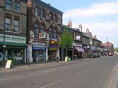
- Map of Withington Manchester UK
- Drive through withington manchester
- Middle Ages
- Tudor Stuart and Georgian periods
- Victorian and later periods
- Aviation
- Governance
- Demography
- Geography
- Landmarks
- Transport
- Education
- Police service
- Notable people
- References
Map of Withington, Manchester, UK
In the early 13th century, Withington occupied a feudal estate that included the townships of Withington, Chorlton-cum-Hardy, Moss Side, Rusholme, Burnage, Denton and Haughton, held by the Hathersage, Longford and Tatton families, and within the Manor of Manchester and Hundred of Salford in historic county boundaries of Lancashire.
Withington was largely rural until the mid-19th century when it experienced rapid socioeconomic development and urbanisation due to the Industrial Revolution, and Manchester's growing level of industrialisation. Withington became part of Manchester in 1904.
Today, the residents of Withington comprise a mixture of families, university students and affluent "young professionals"—often themselves former students. This is in a large part due to its education links—particularly the proximity to the University of Manchester and Manchester Metropolitan University. As a consequence, Withington is predominantly an area of mixed affluence. It is also a centre for clinical excellence with one of the largest cancer treatment centres in Europe—Christie Hospital—and Withington Community Hospital.
Drive through withington manchester
Middle Ages
In Anglo-Saxon times the area was sparsely settled by Mercians and Danes and Didsbury may have been established in King Edward the Elder's reign as a fortification against the Danes. Following the Norman Conquest the lands of south Lancashire were granted to Roger of Poitou and by the early 13th century the Manor of Withington appears to be a sub-manor of the Manor of Manchester. The first recorded description of Withington dates from 1186, calling the area a willow-copse farmstead, and giving rise to the Anglo-Saxon name Wīðign-tūn, with withy meaning "willow branch used for bundling". In the early 13th century, the Manor of Withington covered a wide area including Withington, Didsbury, Chorlton-cum-Hardy, Moss Side, Rusholme, Burnage, Denton and Haughton. The first Lord of the Manor of Withington is thought to have been William, son of Wulfrith de Withington.
Withington was one of the townships of the ancient parish of Manchester in the Salford Hundred of Lancashire, and a sub-manor of the Manor of Manchester. In the 13th century, Robert Grelle (sometimes Grelley), Lord of the Manchester Manor, granted free warren in Withington to Matthew de Hathersage (or Haversage), son of William, in exchange for one knight's fee. Little is known of the Hathersage family, except that they descended to the Longford family, and are connected with the manors of Hathersage and Longford, both in Derbyshire. The lordship of Withington remained in the Hathersage/Longford family for over 300 years.
Tudor, Stuart and Georgian periods
At the end of the 16th century, Nicholas Longford sold Withington to the Mosleys (originally 'Moseley'), an influential Anglo-Irish family of wool merchants who subsequently became wealthy landowners in Staffordshire: Nicholas Mosley later became Lord of the Manor of Manchester. Hough End Hall was built by Sir Nicholas Mosley in 1596 as the new Withington manor house—the original medieval manor house was situated south-east of the modern junction of Mauldeth Road West and Princess Road, which was surrounded by a moat. In 1750 it was demolished to make way for a farm building, but some of the moat was left. An Ordnance Survey map of 1845 shows it as "Withington Old Hall", and it later came to be known as "Chorlton's Farm" or "Old Hall Farm". Today, the site is occupied by Eddisbury Avenue and no trace remains of the old house. There are still today some remnants of this moat underneath Old Moat Primary School, on Old Moat Lane. In the early 18th century, the Withington Manor was once again sold, this time to the Egertons of Tatton.
Withington as a village developed around Wilmslow Road, a Turnpike Road, administered by the Manchester to Wilmslow Turnpike Trust which was the only direct route between Manchester and Wilmslow at the time. Farming still dominated the area, although there is evidence in maps of a substantial cotton house on Cotton Lane, which later appears to become Withington Hall. Some historians dispute the cotton house as there is little record of it, and claim "Cotton Lane" comes from land in the area which was jointly held by the townships of Withington, Didsbury and Burnage (a relic of the medieval open field system). This area was the old village centre however, although the only relic of its former importance is the small flower display on the corner of Wilmslow Road and Cotton Lane.
Victorian and later periods
The trade in Withington, and consequent traffic on Wilmslow Road, increased steadily as the city of Manchester flourished in the early 19th century. Turnpike roads subsequently became increasingly unpopular, and were abolished completely in 1881. Wilmslow Road as a turnpike road would have been abolished as soon as 1861 had the Manchester to Wilmslow Turnpike Trust not agreed to build a new turnpike road to Northenden, named Palatine Road. Cheaper transport in and out of Manchester became an important factor in the growth of the area. In 1880 a tramway was built along Wilmslow Road and Palatine Road to the newly opened Withington and West Didsbury railway station, run by the Midland Railway. The horse trams ran until 1 December 1902 when the first electric trams came into operation. The train service from Withington and West Didsbury railway station to Manchester Central railway station operated until Didsbury railway station closed in 1961.
Withington's Parish Church of St Paul was built in 1841, and many other chapels and churches proliferated, including Methodist, Presbyterian and Roman Catholic. (The architects of St Paul's Church were Hayley & Brown and it was extended in 1864.) Withington has also been home to Spanish and Portuguese Sephardi Jews: synagogues opened in the late 19th century.
Aviation
A large aerodrome was built in 1917-18 on the westerly edge of Withington, to the southwest of the junction of Mauldeth Road and Princess Road, on what is now the site of Houghend Playing Fields. The official name was Alexandra Park Aerodrome, but it was also variously referred to as "Withington" and "Didsbury". Closure came in autumn 1924 when Lord Egerton of Tatton would not agree to the site's continued use for flying. The large hangars were then demolished and Princess Road extended southwards through the eastern edge of the site.
On 28 April 1910, French pilot Louis Paulhan landed his Farman biplane in Barcicroft Fields, Pytha Fold Farm, on the borders of Withington, Burnage and Didsbury, at the end of the first powered flight from London to Manchester, with a six-hour overnight stop near Lichfield, Staffordshire. Paulhan beat the British contender, Claude Grahame-White, winning a £10,000 prize offered by the Daily Mail. Two special trains were chartered to Burnage railway station to take spectators to the landing. Paulhan's progress was followed throughout by a special train carrying his wife, Henri Farman and his mechanics. A house in Paulhan Road is marked by a blue plaque to commemorate his achievement.
Governance
Withington was anciently a township within the parish of Manchester and Hundred of Salford. Under the feudal system, Withington had been governed by its own court leet, and this tradition continued well into the 19th century. The court used to meet at the Red Lion public house on Wilmslow Road until 1841. Following the Public Health Act 1875, Withington Town Hall was built in 1881 on Lapwing Lane, originally to house Withington Local Board of Health, then later occupied by the Withington Urban District Council, under the Local Government Act 1894. In 1904, Withington formally became part of the City of Manchester. The old Town Hall building has been converted into private apartments with new-build apartments to the south (back) and east (side).
Manchester Withington is a Parliamentary Constituency which encompasses Withington village, Chorlton-cum-Hardy, Burnage and Didsbury (East and West). Manchester Withington became the first constituency in the City of Manchester since 1929 to elect a Liberal (Democrat) MP upon John Leech's gain in the 2005 General Election, when the constituency also experienced the largest swing of that election, taking the previously 11,524 majority Labour safe seat by 667 votes – a swing of 17%. This was possibly attributable to the constituency's large student population. The previous incumbent of the seat, Keith Bradley, had held the seat for Labour for 18 years; Lucy Powell was chosen as the successor candidate to Keith Bradley in March 2007, to try to regain the seat at the next general election. However, Leech retained the seat for the Liberal Democrats at the 2010 General Election, with 44.6% of the vote (an increase of 2.4% over 2005); Powell came second with 40.5% of the vote (a decrease of 0.4%).
Historically, Withington was a much larger area than today. Since the district was absorbed into the City of Manchester in 1904, the three city wards of Didsbury, Fallowfield, and Withington took on their own identities and are now seen as distinct areas. The Conservative Party could once regard this area as a heartland for them, with its largely middle class population and relatively suburban image. The 'flight of the middle classes' to rural Cheshire, however, led to many of Withington's larger homes being sold off for student flats. This resulted in a changing socio-economic structure that would ultimately favour Labour and more recently, for a time, the Liberal-Democrats.
In the 2011, 2012 and 2014 local government elections however the Liberal-Democrats lost every Council seat in Withington Constituency and in the City of Manchester as a whole that they contested, leaving Labour with 95 out of 96 Council seats.
Today, the name Withington tends to refer to the areas roughly defined by the modern council wards of Withington and Old Moat, although fluctuating local government boundaries sometimes make these distinctions unclear. Withington and Old Moat wards are currently represented on Manchester City Council by three councillors each: Chris Paul (Labour and Co-operative Party), Daniel Gillard (Labour), and Rebecca Moore (Labour) in Withington; Andrew Fender (Labour), Suzannah Reeves (Labour) and Jeff Smith (Labour) in Old Moat. Council elections took place on 22 May 2014 with each ward returning one councillor, Rebecca Moore and Suzannah Reeves respectively in Withington and Old Moat wards.
Demography
According to the 2001 census
Geography
At 53.433°N 2.229°W / 53.433; -2.229, Withington is located immediately below the midpoint of the Greater Manchester Urban Area, 4 miles (6.4 km) south of Manchester city centre.
Landmarks
Withington today retains some grade II listed buildings, including
Other places of historical interest in Withington include:
Transport
Withington has bus links into the Manchester city centre, partly because of its position on the Wilmslow Road bus corridor which is served by very frequent buses and has been said by some analysts to be the busiest in Europe. The majority of services are operated by Stagecoach Manchester and First Greater Manchester. Other bus routes run along Burton Road and Old Moat Lane to the City centre, and there are also bus routes crossing Withington East-West.
Withington village does not currently have a named or direct railway station—the nearest rail link is Mauldeth Road railway station, located to the east in Ladybarn. The old Withington and West Didsbury railway station on Palatine Road, run by the Midland Railway, closed in 1967 during the Beeching Axe era, but as part of the Manchester Metrolink expansion, the old Midland railway line has been reopened for light rail operation through Withington as far as East Didsbury, known as the South Manchester Line. Metrolink trams now run from the city centre through Chorlton to East Didsbury, with the Withington area being served by new tram stops on Princess Parkway (called Withington), Burton Road and the re-opened West Didsbury station.
The proposed Metrolink extension has had several false starts. Building a light rail link through Withington was first proposed in the early 1980s but funding was not secured until the 21st century. The project was then put on hold due to escalating costs; new funding was sought through the Manchester Congestion Charge, but this was rejected in a public referendum in 2008. The project was revived in May 2009 with a new funding package from local and national government. Clearance work began on the line in 2011, and it was completed in 2013.
Education
Withington Girls' School was established in 1890 and provides private education for girls aged 7 to 18. Notable alumni include Judith Chalmers.
In the 1930s, the Manchester Grammar School moved to new premises in Fallowfield, from its original position near the site of the present Manchester Cathedral. Although seen to be in Fallowfield, its location could be argued to be within the boundaries of the Withington locality. The school has been attended by actors such as Ben Kingsley and Robert Powell, cricketer Mike Atherton, and writer and broadcaster Martin Sixsmith.
Withington is served by the following local primary schools:
Police service
Withington is covered by the South Manchester Division of Greater Manchester Police.
Notable people
Lindsay Bury, a footballer who helped the Old Etonians win the FA Cup in 1879 and made two appearances for England in the 1870s was born in Withington on 9 July 1857.
Academy Award-winning actor Robert Donat, was born in Withington in 1905, making his most acclaimed starring in the 1939 film Goodbye, Mr. Chips. The film critic C.A. Lejeune was born here in 1897. In 1911, the Austrian philosopher Ludwig Wittgenstein was known to have lodgings at 104 (now 154) Palatine Road while he was a student at the Victoria University of Manchester.
Dame Kathleen Ollerenshaw, who was a Conservative councillor for Rusholme for 26 years and a post-graduate of the University of Oxford, was born here in 1912.
Ernest Rutherford, who pioneered the orbital theory of the atom, lived in the village between 1898 and 1910. He is commemorated with a blue plaque on the house in which he lived on Wilmslow Road, now called "Rutherford Lodge".
Alan Erasmus, co-founder of Factory Records and the Haçienda with Tony Wilson, has lived on Palatine Road for over 30 years.
Actor John Mahoney, who became known for his role in Frasier, lived here until 1959. Richard Madeley and his wife, Judy Finnigan, lived on Old Broadway during the 1990s.
Frank Whitcombe Jr, Rugby Union player for Bradford and Yorkshire, was born in Withington.
Martin Lewis, the financial broadcaster who is known for his MoneySavingExpert.com website was born in Withington.
Kate Richardson-Walsh, the Gold medal winning Team GB hockey player, was born in Withington.
Oliver Cookson, the entrepreneur who is best known for founding Myprotein was born in Withington hospital in 1979.