
Length 145 km | Country United States of America | |
 | ||
Bridges Robbins Nest Covered Bridge Cities | ||
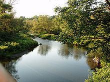
The Winooski River (formerly the Onion River) is a tributary of Lake Champlain approximately 90 miles (145 km) long in the northern half of Vermont. Although not Vermont's longest river, it is one of the state's most significant, forming a major valley way from Lake Champlain through the Green Mountains towards (although not connecting in drainage to) the Connecticut River valley.
Map of Winooski River, Cabot, VT, USA
The river drains an area of the northern Green Mountains between Vermont's capital of Montpelier and its largest city of Burlington. It rises in the town of Cabot, in Washington County, north of Montpelier, and then flows southwest to Montpelier, passing through the city along the south side of downtown and the Vermont State House. From Montpelier it flows northwest into Chittenden County through Richmond, passing north of the city of Burlington. It enters the eastern side of Lake Champlain approximately 5 miles (8 km) northwest of downtown Burlington. The City of Winooski sits along the river approximately 8 miles (13 km) upstream from its mouth, on the northeastern edge of Burlington. The river was historically used for the transportation of timber in the logging heyday of Vermont during the 19th century. The valley of the river downstream from Montpelier is where both U.S. Highway 2 and Interstate 89 run between Montpelier and Burlington.
The river is one of several antecedent rivers in Vermont which predate the rise of the ancient Green Mountain range, and have cut through these mountains as they rose and eroded.
In the late winter of 1992, ice blockage in the Winooski caused a major flood in Montpelier, causing extensive damage to much of the downtown, the worst flood in Montpelier's history since the larger Great Flood of 1927.
The river is used for a variety of purposes. It is popular for recreational uses such as canoeing, kayaking, fishing and swimming. Additionally, a number of hydroelectric dams are used for generating electricity.
The Winooski One Dam, located on the river in the City of Winooski, was the first high performance civil structure in the world imbedded with fiber optic sensors when it was built in 1992. For this reason, the dam was listed in the Guinness Book of World Records as the "world's most intelligent dam."