
Country United States County Chittenden Time zone Eastern (EST) (UTC-5) Elevation 88 m Population 4,081 (2010) | Incorporated 1794 Area code(s) 802 Zip code 05477 | |
 | ||
Weather 3°C, Wind N at 16 km/h, 59% Humidity Area 84.69 km² (83.4 km² Land / 129 ha Water) | ||
Richmond is a town in Chittenden County, Vermont, United States. As of the 2010 census the population was 4,081.
Contents
Map of Richmond, VT, USA
The main settlement of Richmond in the north-central part of town is a census-designated place (CDP), with a population of 723 at the 2010 census.
History
In 1775, Amos Brownson and John Chamberlain made the first settlement attempt. They abandoned their efforts in the fall of that year, but returned in the spring of 1784, at the close of the Revolutionary War. Richmond was incorporated by the General Assembly on October 27, 1794, then organized in 1795. The Winooski River and Huntington River both offered locations for water mills. Industries began to manufacture wagons, harnesses, tinware, brass, cabinet work and woodenware. By 1859, the population was 1,453.
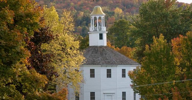
Richmond is noted for the Round Church, a rare 16-sided meetinghouse that was erected in 1812-1813.
Geography
According to the United States Census Bureau, the town has a total area of 32.7 square miles (84.8 km2), of which 32.2 square miles (83.5 km2) is land and 0.54 square miles (1.4 km2), or 1.59%, is water. Richmond is bisected by the Winooski River, with its tributary the Huntington River crossing the southeast corner of the town. Richmond is located in the western foothills of the Green Mountains.
The town is crossed by Interstate 89, with access from Exit 11 in the northwest part of town, by U.S. Route 2, and by the New England Central Railroad.
Schools
Local students attend Mount Mansfield Union High School, Camel's Hump Middle School and Richmond Elementary School. Mount Mansfield Union High is in the neighboring town of Jericho. The MMU athletic teams are the Cougars, who play the teams of neighboring schools such as CVU.
On November 4, 2014, the communities of Bolton, Jericho, Richmond, Underhill ID and Underhill Town voted to form the Mount Mansfield Modified Union School District also known as the MMMUSD. This new school district will serve and govern the current town school districts of Bolton (Smilie Memorial School), Jericho (Jericho Elementary), Richmond (Richmond Elementary), Underhill ID School District (Underhill ID Elementary), Underhill Town (Underhill Central School), Mt Mansfield Union School District (Browns River Middle, Camels Hump Middle and Mt. Mansfield Union High Schools) in grades Pre-K through 12 and Huntington students grades 5-12.
Demographics
As of the census of 2000, there were 4,090 people, 1,504 households, and 1,100 families residing in the town. The population density was 128.4 people per square mile (49.6/km2). There were 1,528 housing units at an average density of 48.0 per square mile (18.5/km2). The racial makeup of the town was 98.36% White, 0.05% African American, 0.12% Native American, 0.51% Asian, 0.02% Pacific Islander, 0.07% from other races, and 0.86% from two or more races. Hispanic or Latino of any race were 0.83% of the population.
There were 1,504 households out of which 41.2% had children under the age of 18 living with them, 62.2% were married couples living together, 7.8% had a female householder with no husband present, and 26.8% were non-families. 18.4% of all households were made up of individuals and 4.0% had someone living alone who was 65 years of age or older. The average household size was 2.71 and the average family size was 3.13.
In the town, the population was spread out with 29.3% under the age of 18, 5.4% from 18 to 24, 34.1% from 25 to 44, 24.5% from 45 to 64, and 6.8% who were 65 years of age or older. The median age was 37 years. For every 100 females there were 95.7 males. For every 100 females age 18 and over, there were 96.0 males.
The median income for a household in the town was $57,750, and the median income for a family was $66,875. Males had a median income of $36,161 versus $30,019 for females. The per capita income for the town was $25,692. About 3.2% of families and 5.1% of the population were below the poverty line, including 6.2% of those under age 18 and 5.8% of those age 65 or over.