
Elevation 7,711 ft (2,350 m) Width 9 mi (14 km) E-W | Length 14 mi (23 km) N-S Country United States of America | |
 | ||
Similar Apache Peak, Mount Glenn, Carr Peak, Chiricahua Peak, Kartchner Caverns State Park | ||
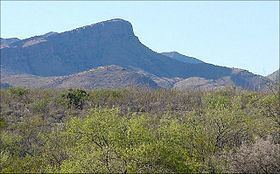
The Whetstone Mountains is a mountain range in Cochise County, southeastern Arizona.
Contents
Map of Whetstone Mountains, Arizona 85602, USA
GeographyEdit
The range is located south of Interstate 10, between the Santa Rita Mountains to the west, and the Dragoon Mountains to the east. Higher elevations of the major ranges in the region are in the Madrean Sky Islands ecoregion, with sky island habitats.
Located within the Coronado National Forest, the Whetstone Mountains are in its Sierra Vista Recreation Area, with access via hiking trails.
Kartchner Caverns State Park is in the eastern foothills of the Whetstone Mountains, on Arizona State Route 90. The trailhead for the Foothills Loop Trail is in the park.
PeaksEdit
Peaks in the range include:
HistoryEdit
At Iron Springs, within the Whetstones is where Wyatt Earp fought in a gunfight during the Earp Vendetta Ride, 1882.