
Topo map USGS Chiricahua Peak Mountain type Volcanic Prominence 1,569 m | Age of rock 27 Ma Elevation 2,975 m | |
 | ||
Listing US most prominent peaks 119th Similar Miller Peak, Carr Peak, Mount Glenn, Apache Peak, Thimble Peak | ||
Chiricahua Peak is the name of a 9,763 feet (2,976 m) peak located in the Chiricahua Mountains of southeastern Arizona, located about 35 miles (56 km) north of the United States–Mexico border. It is the highest summit in the Chiricahua Mountains and the highest point in Cochise County.
Map of Chiricahua Peak, Arizona 85607, USA
As with the rest of the Chiricahua Mountains, the peak was formed as the result of a violent volcanic eruption about 27 million years ago.
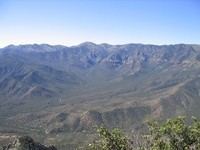
The peak contains one of the southernmost Engelmann spruce stands in the world. There are also extensive stands of aspen on the northslope. Much of the peak was severely burned in recent times, which creates vast open views across the landscape. This includes views across the Basin and Range to Mount Lemmon, Mount Graham, and Mount Wrightson. In addition Willcox Playa is visible in the basin below.
In 2011 the Horseshoe 2 Fire burned a total of 223,000 acres (90,000 ha) within the Chiricahua Mountains causing considerable damage to the trail system.