
Population 637 in (2011) Unitary authority Area 5 ha Year built 1850 | OS grid reference SU132680 Local time Friday 10:08 PM Added to NRHP 18 July 1985 | |
 | ||
Weather 12°C, Wind W at 16 km/h, 90% Humidity | ||
West Overton is a village and civil parish in the English county of Wiltshire, about 3.5 miles (5.6 km) west of Marlborough. The river Kennet runs immediately north of the village, separating it from the A4.
Contents
Map of West Overton, PA 15683, USA
Local government
The parish elects a joint parish council with the adjacent parish of Fyfield; the council is named Fyfield and West Overton. It falls within the area of the Wiltshire Council unitary authority, which is responsible for all significant local government functions.
Until the 19th century the parish of Overton had chapelries at Alton Priors and Fyfield, and tithings of East Overton, Lockeridge, Shaw, and West Overton. In the 19th century Alton and Fyfield became separate civil parishes while East Overton ceased to be used as a place name. The village of Shaw, southwest of West Overton, was apparently deserted in the 15th century; Lockeridge continues as a village in West Overton parish.
Church and chapel
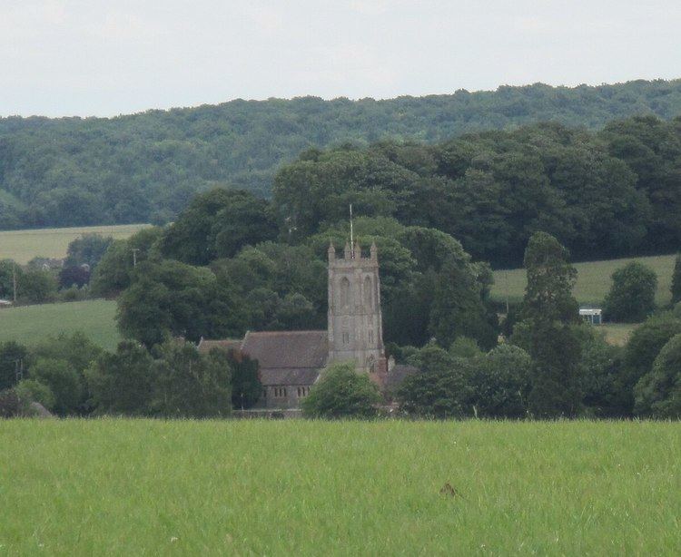
The Anglican Church of St Michael and All Angels was built in 1878 to designs of C.E. Ponting and incorporates some features from the 13th century building it replaced. The church is Grade II* listed.
From 1901 to 1966 there was a Methodist chapel at West Overton.
Amenities
A National School was built at Lockeridge in 1875 to serve the parishes of West Overton and Fyfield. The building (and extensions) continues in use as Kennet Valley C of E Voluntary Aided Primary School.
The parish has a village hall, Kennet Valley Village Hall, near Lockeridge.
Landmarks
North of the A4, the parish extends onto the Marlborough Downs. On Overton Down is an earthwork built in 1960 as a long-term archaeology experiment. The Piggledene valley, with its sarsen stones, is a biological and geological Site of Special Scientific Interest managed by the National Trust.
Overton Hill, with prehistoric features including The Sanctuary, is to the west of the village and partly in Avebury parish. The ancient Ridgeway, now a national trail, begins here and follows the parish boundary northwards.
The medieval Wansdyke earthwork crosses the southernmost part of the parish.