
Urban agglomeration Montreal Postal code span H8Y to H9X Area 150.1 km² | Province Quebec Time zone Eastern (EST) (UTC−5) Area code(s) (514) and (438) | |
 | ||
Weather 1°C, Wind E at 11 km/h, 94% Humidity | ||
poptropica wild west island full walkthrough
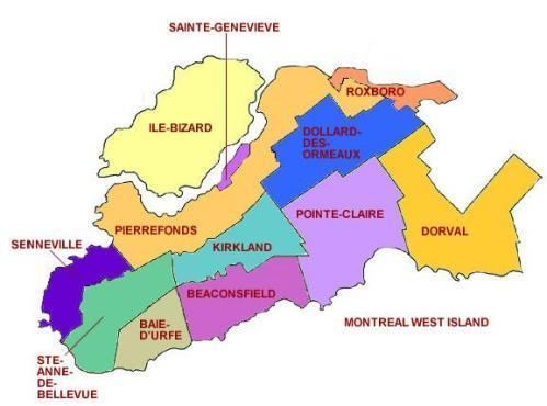
The West Island (in French, l'Ouest de l'île) is the unofficial name given to the cities, towns and boroughs at the western end of the Island of Montreal, in Quebec, Canada. It is generally considered to consist of the cities of Dorval, Pointe-Claire, Kirkland, Dollard-des-Ormeaux, Beaconsfield, Baie-D'Urfé, Sainte-Anne-de-Bellevue, the village of Senneville, and two boroughs of the city of Montreal: Pierrefonds-Roxboro and L'Île-Bizard–Sainte-Geneviève. Furthermore, given the nature of suburban demographic development in Montréal, off-island suburbs towards the west of the island (such as Vaudreuil, Pincourt, Hudson, and Saint-Lazare) in addition to outer-ring boroughs of Montréal (such as LaSalle, Lachine and Saint-Laurent) are often considered part of the West Island. This is in large part due to similarities in personal income, design of the communities, services available (and shared), quality of life and economic engines supporting the population.
Contents
- poptropica wild west island full walkthrough
- Camp cosmos west island
- Pre contact colonial and agricultural eras
- Historical maps
- Early 21st century merger and demerger
- Housing and infrastructure
- Geography
- Flora and fauna
- Nature parks
- Municipalities and boroughs
- Demographics
- Language spoken at home
- Education
- Media
- Sports and recreation
- Points of interest
- References
Historically, there was a linguistic division of the island of Montreal into French and English 'halves', with Francophones typically inhabiting the eastern portion of the island and Anglophones typically inhabiting the western half. The West Island's population is approximately 234,000 and although the overwhelming majority of its residents are today bilingual if not multi-lingual, (given the cosmopolitan nature of this vast suburban area), anglophones still make up a plurality of the West Island's population. Given its population, the West Island is similar in size to Windsor, Kitchener, Longueuil, Saskatoon, Burnaby or Regina. Curiously, as late as the 1960s, much of the West Island was farmland populated by French Canadians, which in turn accounts for a significant Francophone cultural influence in the region.
The region is home to the Montréal–Pierre Elliott Trudeau International Airport, John Abbott College, Cégep Gérald-Godin, the Macdonald Campus of McGill University, the Fairview Pointe-Claire and Galeries des Sources malls, as well as Montreal's largest park, the Cap-Saint-Jacques Nature Park. Hospitals include the Veteran's Hospital in Sainte-Anne's and the Lakeshore General Hospital in Pointe-Claire. Municipalities range in character from the modern bedroom communities of Kirkland or Dollard-des-Ormeaux to the former cottage-country homes of Dorval, Pointe Claire and Beaconsfield. Development and the concentration of industrial activity along highways 20, 40 and 15 over the last twenty years has made securing the region's remaining tracts of open land a priority for many West Island residents. Indeed, the West Island is home to one of the last large remaining tracts of Montreal-region wilderness on island.
Camp cosmos west island
Pre-contact, colonial and agricultural eras
The history of human settlement in the West Island of Montréal likely predates European colonization beginning (in earnest) towards the early-mid 17th century, but far too little is known of the history of the St. Lawrence Iroquoians who inhabited the island in the pre-colonial era. Indeed, between Cartier's first contact in 1535–1536 and the arrival of Champlain in 1608, the local Iroquoians had completely disappeared, most probably from near-constant warfare with other neighbouring Iroquois tribes, particularly the Mohawk. The West Island may have had areas of regular human habitation as the history of human settlement in Montreal goes back at least as far as 8,000 years.
European colonization led to the establishment of parishes and small trading outposts along a Chemin du Roy laid out in the 17th century that corresponds more or less directly with the Gouin & Lakeshore boulevards of today. Lachine, Sainte-Anne-de-Bellevue, Sainte-Genevieve and Pointe-Claire developed in a more or less interconnected fashion as colonial outposts spread out along the edge of the island. During the Ancien Régime of the early colonial era, these communities had their own parish churches, many of which still exist. In addition to the churches and rectories, religious orders of various types had set up monasteries and convents, novitiates and the like throughout the West Island, given its proximity to Ville-Marie. Seigneurial system land divisions and the development of the 'montée & rang' main road system allowed for the development of a vast agricultural territory, protected by forts, seigneurial manor houses and the geographic advantages of being on a densely forested island. Though much of the West Island is today a vast low-density modern suburban development, most of the principal roads were developed in the 17th and 18th centuries, inasmuch as land division follows examples common to the Ancien Régime. Moreover, the West Island has a small number of critical 18th century heritage properties, in addition to parish churches, summer villas, windmills and the remnants of Fort Senneville, constituting the principle remnants from the early and middle colonial period in this area. Other important heritage properties include the numerous 19th century summer homes, farm houses and the turn of the century villages in Pointe-Claire, Saint-Anne's or Sainte-Genevieve. A key element of local architecture, as noted by author-historian Jean-Claude Marsan, is that the Habitant house-style of the 17th century proved so reliable, affordable and aesthetically pleasing it was repeated well into the 20th century with few major structural modifications. Houses of this kind can be found throughout the region.
Key early settlements leading up to the major post-war suburban developments include:
Dorval, founded 1665–1667 as a Sulpician mission, it became a village in 1892, a town in 1903 and a city in 1956. Its development came largely in 1855 when the Grand Trunk Railroad established a station at Dorval, leading the hamlet to develop into a summer retreat for wealthy early-Victorian Era Montreal elites. Later, through the start of the century until the Second World War, the village became a town well known for its beaches on Lac St-Louis.
Sainte-Anne-de-Bellevue, first explored and settled between 1663 and 1712, though widely used by Iroquois and Algonquins for hundreds if not thousands of years before contact, due to its strategic importance at the confluence of the Ottawa and Saint Lawrence rivers and at the western tip of the Island of Montreal. A mission was established at the present site of the Baie-D'Urfé Yacht Club in 1663, while Fort Senneville was developed beginning in 1671. A post office was established in 1835 while the Saint Anne Canal was established in 1843. Train service on the Grand Trunk began in 1854, and the village was first incorporated a year later. Though the village had been principally oriented on parish activities and agriculture throughout the 19th century, the early 20th century saw the development of Macdonald College in 1907, the creation of Gardenvale and the Harpell/Garden City Print Company, an important industrial cooperative, in addition to the Veterans Hospital in 1917.
Historical maps
Early 21st century: merger and demerger
As part of the 2002–2006 municipal reorganization of Montreal, all the cities of the Island of Montreal, including those in the West Island, were merged into the expanded city of Montreal on January 1, 2002. However, following a change of government and a 2004 referendum, the residents of most West Island cities voted for demerger, and were re-constituted effective January 1, 2006. However, they remained part of a new supra-municipal structure: the urban agglomeration of Montreal. Pierrefonds, Roxboro, Sainte-Geneviève and Île-Bizard remained in Montreal, as the boroughs of Pierrefonds-Roxboro and L'Île-Bizard–Sainte-Geneviève, respectively.
One argument for amalgamation was that West Islanders enjoyed lower taxes than the old city of Montreal, but still used its theatres, concert halls, and museums. With amalgamation, tax rates were harmonized across the island. In fact, the West Island contains several wealthy neighbourhoods, parks and historical sites.
Prior to 1980, people seldom used the term "The West Island". When referring to the towns that touch Lake Saint-Louis, such as Dorval, Pointe-Claire and Beaconsfield, people called the area the Lakeshore. Whereas in reference to towns that touch Lake of Two Mountains and Rivière-des-Prairies, such as Pierrefonds, Sainte-Geneviève and Roxboro, they called the area the North Shore.
Housing and infrastructure
The West Island has a cosmopolitan feel and an at times eclectic design (with modern buildings and classic Québécois country homes side by side). The region boasts large green spaces bordering rivers and lakes, bike trails, nature parks, museums, cross-country ski trails, ecological farms, golf courses and cultural sites. As a testimony to its 300-year-old history, residents and visitors alike will discover 18th-century buildings along the former Chemin du Roy, today Gouin Boulevard and Chemin du Bord-du-Lac, in addition to the remnants of Fort Senneville. The shores of Lake Saint-Louis offer a unique setting with café-terrasses, restaurants and boutiques filled with quaint Old World charm. The area today is largely middle and upper-middle class residential zoning along with the strip-malls and other services one might expect in a North American mega-suburb. Large tracts were developed in the period 1955–1975 (such as Dollard-des-Ormeaux, Pierrefonds, Roxboro and Kirkland) where the majority of homes are similarly-sized variations of the basic bungalow design, though with traditional Québécois architectural influences. Lots tend to be more or less even in size without much variation across entire cities or boroughs. As such, the West Island tends to give the impression of being a somewhat homogeneous construction.
Geography
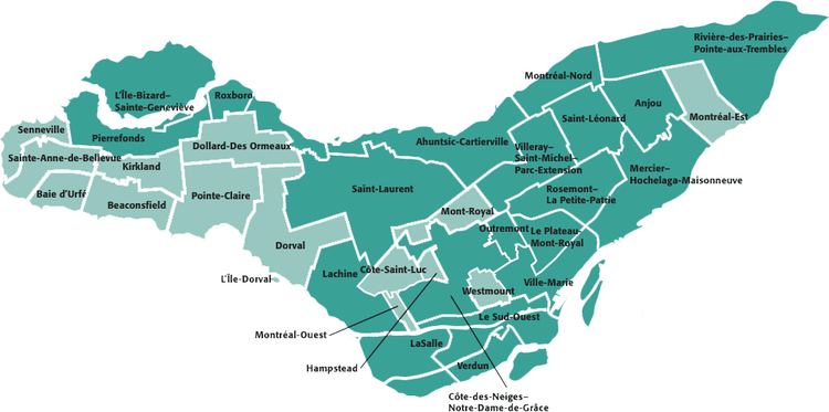
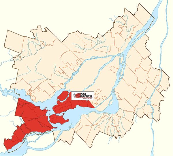
The West Island is an informal term for a large territory of low-density middle and upper-middle class housing, low and medium density commercial sectors and vast industrial operations roughly constituting the western third of the Island of Montreal. As such there are no precise boundaries, but rather a fundamentally similar cultural and societal identity. The West Island is not a city, but rather a collection of independent cities, towns and villages in addition to several borough of the City of Montreal that share an intimate relationship and identity with the citizens of Montreal, and yet have also developed a unique common identity and strong sense of local character. Again, for this reason it is difficult to say exactly which communities constitute the West Island, though it is largely understood to mean all communities, independent or otherwise, developed on the island of Montreal West of Highway 13 and 32nd Avenue. Some would argue the communities of Saint-Laurent, Lachine and LaSalle, in addition to the western off-island communities, such as Vaudreuil-Dorion, Hudson and the four communities of Île Perrot should be included in which communities define the West Island, given the common threads of settlement and factors determining their development.
The environment and climate of the West Island is almost identical to that of Montreal, and is affected by the same ecological conditions, namely, it is a large open plain of wide plateaus and marshland. The West Island is surrounded by the other islands in the Hochelaga Archipelago as well as Lake of Two Mountains and Lac Saint-Louis and their inter-connected rivers and creeks. The territory was largely agricultural from the 17th century into the mid-20th, when it was then quickly developed into a sprawling network of bedroom suburbs. The West Island has numerous large tracts of uncultivated land, some of which are protected parks while in other cases they're merely the fallow fields of former farms, waiting to be sold to residential property developers. Other portions of land have been designated for the construction of a highway to connect the 40 with the 440, through Kirkland, Pierrefonds, Ile Bizard and Laval, but the plan has gone nowhere. A significant portion of the Northwestern corner of the West Island is so sparsely developed it constitutes the last portion of Montreal's pre-settlement ecosystem. Though agriculture on the island is limited to the Macdonald Experimental Farm, the remnants of farmland in Senneville and Pierrefonds are likely to be developed into low-density residential housing. Conserving the remaining segments of local island wilderness has become a focal point of West Island politics over the course of the last thirty years, and is point of common concern.
Flora and fauna
Due to the primarily residential character of the West Island and the influence of the City Beautiful and Garden City movements in residential urban-planning in older suburbs on island, the West Island is primarily composed of single-family dwellings on spacious lots organized along small winding roads leading away from large thoroughfares. The area is notable for its many parks and a general emphasis on retaining as much of the rustic, rural charm that characterized the region and led to its development as a popular summer retreat in the early part of the 20th century
Due to these and other traits, a wide variety of flora and fauna common to the Saint Lawrence river valley can be found in a somewhat balanced natural ecosystem in the largely undeveloped Northwestern corner of the West Island, in addition to the developed low-density residential areas. Flora and fauna found in the West Island fall within the broader spectrum of the Eastern Great Lakes lowland forests ecoregion. Of note is the presence of non-native, borderline hardiness trees, such as the tulip tree, which thrive in small section of Senneville near the Île aux Tourtes Bridge.
Among others, mammal species that inhabit the greater West Island region include white-tailed deer, coyote and cottontail rabbits. the current population of white-tailed deer is quite substantial, It is estimated that there is over a thousand individuals in the deer population. It is not uncommon for moose to occasionally cross the ice onto the island in winter. Other species endemic to the western portion of the island include grey squirrels, red squirrels, flying squirrels, mink, chipmunks, raccoons, beaver, skunks, porcupines, martens, woodchucks, muskrat, otters, and fox. The number of bird species varies according to season and migration. During spring and fall many species pass through the area on their way to southern breeding grounds. During winter months, depending on climatic conditions and availability of food in the northern Quebec, many species of birds will take up temporary residence, such as great grey owls, snow buntings, snowy owls,and others. The West Island has enough variation in suitable habitats, such as marsh, ponds, forest and field that many species of birds nest here. Various species of reptiles which can be found include garter snakes, red bellied, brown, milk and the northern water snake. Species of turtles include painted, map and snapping turtle. Amphibians include bullfrogs, green frogs, leopard frogs, spring peepers, wood frogs, and others. Salamanders such as the eastern newt, red backed salamander, blue spotted salamander are also found in the more humid habitats. In the surrounding waters of the west island, notably the Lake St. Louis side, large fish species such as northern pike, sturgeon, garfish, carp, catfish, muskellunge can be found. Given the Saint Lawrence's heavy traffic and years of mis-use, the ecoregion is negatively effected by high pollution which in turn has resulted in diminished local populations of native fauna. That said, residential development in the greater West Island suburban region (including the Vaudreuil-Soulanges area and parts of Eastern Ontario), has resulted in occasional sightings of black bears, wolves, lynx and cougars (which are generally believed to be extinct though sightings and some physical evidence suggest otherwise) as they themselves are pushed out of their habitats.
Nature parks
The Morgan Arboretum in Sainte-Anne-de-Bellevue, 610 acres of protected urban forest with over 180 bird species, of which about one-hundred breed within the park. It is also the home to the Ecomuseum Zoo, which features a collection of species native to the Saint Lawrence River valley.
Cap Saint Jacques, Montreal's largest park at 711 acres of protected forest, it features of 30 km of cross-country trails, a beach and a small organic farm.
There are also the L'Anse-à-l'Orme Nature Park, Angell Woods, Terra Cotta Park, Centennial Park, the Rapides du Cheval Blanc linear park, and the Bois-de-Liesse Nature Park which constitute the major forested areas of the West Island, while remaining community green spaces are typically designed in a conventional park layout. The other principle large open green spaces include Macdonald Experimental Farm and the remaining tracts of open land around the Morgan Arboretum in Senneville and western Pierrefonds.
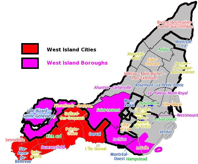
Municipalities and boroughs
The West Island consists of the following towns, cities and boroughs:
These independent communities constitute the de-merged West island municipalities. In addition, there are two City of Montreal boroughs:
Demographics
Population
City of Montreal boroughs
Language spoken at home
(Includes West Island municipalities only, not West-Island boroughs of Montreal.) From Canada 2006 Census
The West Island can also claim to have the highest demographic concentration of German Canadians in the province of Quebec. With an even higher concentration located in the Town of Baie-D'Urfé, where the German language school, The Alexander von Humboldt Schule Montréal – German International School is located.
Education
Post-secondary institutions:
The Macdonald Campus of McGill University, which traces its roots back to 1905, when Macdonald College was originally constructed as an agricultural college. The buildings which currently house John Abbott College are those of the original Macdonald College, which in 1972 became a satellite campus of McGill University and moved into newer buildings east of the original site. The Macdonald Campus supports McGill's Morgan Arboretum, the J. S. Marshall Radar Observatory and the last operational farm on the Island of Montreal, in addition to the Canadian Aviation Heritage Centre.
John Abbott College was opened in the old Macdonald College buildings located in Sainte-Anne-de-Bellevue in 1971 and has since become one of the largest CEGEPs in Quebec, with well-over 7,000 students. The campus was initially split between two sites until the construction of the Casgrain Centre in 1981, and a new science and technology pavilion is currently being completed along with campus-wide renovations and upgrades. The site features the nearly completely abandoned Brittain Hall, the former men's dormitory. In this respect, Brittain Hall is a near identical copy of Stewart Hall (the original women's dorm), and features the same stacked 'gym-cafeteria-pool' layout, along with massive fireplaces and other features of an Edwardian-era rural college dormitory. Today it is still owned by McGill University and is almost exclusively used for film and television production. Despite a rapid increase in school population and the subsequent lack of space, there are no plans to renovate or rehabilitate Brittain Hall at the moment. Another feature of the campus is the location of steam pipes and access tunnels located directly under the sidewalks, so as to permit natural snow-removal. Moreover, there are a series of underground tunnels connecting all buildings on campus, designed so as to facilitate moving about the sprawling campus. A portion of the system connecting Stewart to Brittain Hall, has been closed since the 1970s and remains largely inaccessible.
Cégep Gérald-Godin was opened in a former novitiate of the Fathers of the Holy Cross in 1999 and is a prominent West Island post-modern architectural achievement. It features the Salle Pauline-Julien a performing arts venue, and is home to roughly 1,200 students. It is so far the only uniquely Francophone CEGEP in the West Island. The development of the CEGEP has had a positive impact on the development of the village of Sainte-Geneviève as a smaller primarily Francophone equivalent to Sainte-Anne-de-Bellevue.
Public primary and secondary:
English-language instruction in the West island is provided primarily by the Lester B. Pearson School Board while French-language instruction is provided by the Commission scolaire Marguerite-Bourgeoys. The LBPSB counts some 28,000 students in 12 high schools, 40 elementary schools, 2 adult education centres and 4 vocational schools. The CSMB counts some 45,000 students across a larger territory principally focused on the western portion of the island, with 61 elementary schools, 12 high schools, 2 specialized schools, 6 vocational schools and 4 adult-education centres.
Important West Island public high schools include, but are not limited to:
Beaconsfield High School – founded in Beaconsfield in 1958, 1130 students.
John Rennie High School – founded in Pointe Claire in 1955 it boasts the Sports-Etudes program for student athletes as well as a highly regarded local theatre and dramatic arts program.
Lindsay Place High School – founded in Pointe-Claire in 1962 with 1,600 students, one of the largest in the West Island.
Pierrefonds Comprehensive High School – founded in 1971 in Pierrefonds to support Catholic francophone and anglophone students, it is an architecturally significant school given its open concept design along an axial core, not to mention industrial visual cues, such as exposed concrete walls and overhead pipes, small windows and rooms without doors. Roughly 1200 students attend PCHS, which is co-located with the LBPSB administered West Island Career Centre (WICC). PCHS offers an international baccalaureate program and shares its grounds with the George Springate community sports complex.
Riverdale High School – once one of the largest schools in the West Island (approximately 2,600 students in the early-1970s until the early 1980s), Riverdale's population has declined significantly in the last thirty years, but it still remains a special place in the community of Pierrefonds. An adult education centre now occupies most of the first floor.
Saint Thomas High School – one of the finest public high schools in the West Island, St. Thomas is consistently ranked in the top-ten of Quebec's schools. It offers an IB program and is home to some 1,300 students.
Media
Despite the fact that there are enough 'West-Islanders' to constitute a medium-sized city in Canada, there is a noticeable dearth in local original content media. The West Island Chronicle and West Island Gazette are the two principle English-language weekly newspapers and there are a variety of free local tabloids primarily used for advertising, including the Cité-Nouvelles editions. Montreal Times and The Suburban are more closely focused on Montreal's anglophone population on the whole, but are also available and of general interest to residents the West Island. Other small publications include periodic free 'lifestyle' magazines or 'business-profile' quarterlies, though publication runs are typically very limited. There are no dailies in either language native to the region, as this market is dominated by Montreal's major dailies, such as the Montreal Gazette or La Presse.
The North Shore News once served the communities of Pierrefonds, Roxboro & Dollard-des-Ormeaux when those communities were primarily focused along access routes to and from Gouin and Sources Boulevards and the Sunnybrook and Roxboro train stations. Though the publication was touted as the West Island's only independent weekly throughout the 1960s and 1970s, it died out in the 1980s.
A local radio station operated in Pointe Claire from 1960 to 1989. From its founding until 1977, it held the callsign CFOX and had several different formats including Country music and Top-40. After its sale, it was part of the CKO all-news network. It was located at 1470 kHz in the AM broadcast band. Declining revenue led the station to fold in 1989.
Sports and recreation
The West Island boasts multiple public and private sports and recreation facilities, many of which are co-located at local secondary schools or gathered around municipal buildings. As with many suburban areas, residents have access to numerous community pools, parks, greens and playgrounds, in addition to soccer and football fields, rugby pitches and baseball diamonds. All West Island residents have access to amateur sports clubs and associations, and minor-level hockey, soccer, basketball and football are all quite popular. Moreover, various leagues and associations are generally very open to accepting residents from all communities. As with most Canadian communities, there is at least one hockey rink in every city or town in the West Island. These facilities have, in the past, also served as venues for rock concerts and the like. A notable example was the old Pierrefonds Arena, demolished in the late-1990s, which once attracted bands like the Eagles and Black Sabbath when it was difficult for most West Island youth to reach downtown concert venues.
DDO and Pointe Claire both boast large civic centres replete with Olympic-sized pools and appropriate diving platforms, and the West Island has a noticeable youth subculture focused on swimming, diving and life-guarding at community pools.
The world famous Royal Golf Club of Montreal is located in Ile-Bizard and is one of eight golf greens in the West Island, the majority of which are private. Other typical West Island sports and recreation facilities include numerous tennis clubs and courts, curling clubs and the occasional bocci pitch.
Other notable West Island sports and recreation facilities include the West Island YMCA and YM/YWHA, Dollard-des-Ormeaux's Centennial Park (with hills ideally suited for tobogganing and forests inter-laced with cross-country ski trails), Cap St. Jacques (which features the only remaining beach open to the public on the island) and the facilities affiliated with John Abbott College. In addition, numerous sports leagues for children and youth utilize facilities shared with local primary and secondary schools.
The area is home to the North Shore Lions football Bantam team as well as their older team the North Shore Mustangs, which compete at a midget division 1 AAA level, which holds the most division and provincial titles in Quebec Midget Football League (QMFL) history.
Points of interest
Fritz Farm, a community cultural centre in Baie-D'Urfé located at 20477 Chemin Lakeshore on a large common green bordering picturesque Lac Saint-Louis. Fritz Farm is one of several examples of preserved heritage homes dating back to the 18th century that can be found in Baie-D'Urfé, which are a direct link to the West Island's colonial era.
Église Sainte-Geneviève, a parish church established in 1741 by Antoine Faucon and completed in its present form in 1844. It is located at the intersection of Rue St-Louis and Gouin Boulevard West in the village of Sainte-Geneviève and is part of a larger complex that includes a presbytery and cemetery and a municipal park along the banks of the scenic Rivière des Prairies.
Saint-Joachim de Pointe-Claire Church & Pointe-Claire Village, another parish church established in the mid-18th century, though completed only in 1885 in a Gothic-revival style, designed by noted local church architect Victor Bourgeau. It is located at 2 Ste-Anne Street in Pointe Claire Village. Permanent settlement in this part of the West Island dates back at least as far as 1710, when the emblematic Pointe-Claire Windmill was completed. The Village features many 19th century and early 20th century buildings and forms an important local small-business sector. There are many restaurants and boutiques in the area, in addition to the exclusive Beaconsfield Golf Club and the Pointe-Claire Curling Club. Othe sites of interest include the Pointe-Claire Windmill & Summer Retreat of the Congregation Notre Dame.
Centennial Hall, in Beaconsfield – a community cultural centre and small-scale performance venue.
Stewart Hall, in Pointe-Claire – an art gallery and community cultural centre and small-scale performance venue.
The Museum of Local History and Heritage located at 1850 Lakeshore Drive and adjacent to the large linear parks that stretch from Dorval along the edge of Lac Saint-Louis east towards Old Lachine Village where the old public beaches used to be. There are several marinas in the area and each summer the lake is filled with diverse pleasure craft. Wind-surfing here is quite popular, though public bathing is illegal and generally discouraged. Fishing is popular, though again, it is unwise to consume anything caught.
The Morgan Arboretum and Ecomuseum Zoo, a zoo dedicated to animal species endemic to the Eastern Great Lakes lowland forest, located in one of the last old growth example of the type on-island. The Ecomuseum is, along with Montréal's Biodome and Insectarium, one of the key local public zoological institutions that have found innovative solutions to the problems with 'traditional zoos'.
Old Saint-Anne's Village and the Sainte-Anne-de-Bellevue Canal, another area in the West Island where permanent settlement dates back to the mid-late 17th century, Sainte-Anne's became a focal point for local services with the development of Macdonald College and the Veterans Hospital during the early 20th century. The Village has many restaurants and bars and other services supporting the comparatively large student population. The area features a boardwalk, the old Rex Theatre and numerous specialty shops. Other features include the Gallipeault Bridge which connects Sainte-Anne's to Ile Perot.
The Canadian Aviation Heritage Centre and the Macdonald Experimental Farm, co-located at McGill's Macdonald Campus in Sainte-Anne-de-Bellevue.
Fort Senneville, originally built in 1671 and destroyed and re-built twice, the Fort was captured and destroyed by Benedict Arnold in 1776 during manœuvres associated with the Battle of The Cedars during the American War of Independence. A commemorative plaque located along Chemin Senneville by the Lake of Two Mountains records the location of the battle associated with the fall of the Fort. All that remains today is part of the windmill which doubled as a watch-tower and the foundations of the seigneurial house, if not some portions of the walls. The site is on private property though the proprietor has been known to allow visitors if they ask politely.
Cap-Saint-Jacques Nature Park – the largest nature park on the island also features the only remaining public beach and an organic farm.
Rapides du Cheval Blanc Listed as one of the ten Eco-territories of Montreal The park has a view of the Whitehorse rapids and a wooded area.
Bois-de-Liesse Nature Park, the second largest nature park on-island and home to some protected heritage properties.