
Max. width 3.6 km (2.2 mi) Length 4.5 km | Primary outflows Whiteshell River Max. length 4.5 km (2.8 mi) Area 16.2 km² Surface elevation 329 m Outflow location Whiteshell River | |
 | ||
Primary inflows | ||
West hawk lake the wall
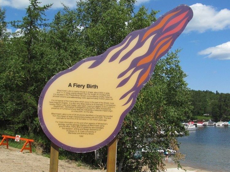
West Hawk Lake is located in the Whiteshell Provincial Park in southeastern Manitoba, Western Canada. The central portion of the lake is formed by the West Hawk crater, caused by a meteor impact into an ancient rock bed composed of mostly granite. Granite cliffs surround parts of the lake. This area is also known as part of the Canadian Shield that was formed billions of years ago. Parts of the Whiteshell park have elaborate petroforms that were made by First Nation peoples, possibly over a thousand years ago. There are petroform shapes of turtles, snakes, humans and geometrical patterns, often found upon pink granite ridges that were shaped during the last ice age.
Contents
- West hawk lake the wall
- Map of West Hawk Lake Division No 1 Unorganized MB Canada
- Exploring west hawk lake manitoba
- References
Map of West Hawk Lake, Division No. 1, Unorganized, MB, Canada
The lake has private cottages, public beaches, campgrounds and other tourism amenities, and extensive undeveloped shoreline, and is popular for boating, sailing, Wakeboarding and scuba diving. It is just north of the Trans-Canada Highway, and on the Trans Canada Trail, on the border of Manitoba and Ontario.
At 115 metres (377 ft), it is the deepest lake in Manitoba.