
- elevation 2,761 ft (842 m) - average 873 cu ft/s (25 m/s) Length 53 km | - elevation 10 ft (3 m) Basin area 549.1 km² Basin area 549.1 km² | |
 | ||
- max 40,400 cu ft/s (1,144 m/s) | ||
The Washougal River is a 33-mile (53 km) tributary of the Columbia River in the U.S. state of Washington. Its headwaters and upper 21 miles (34 km) are in Skamania County in the Gifford Pinchot National Forest, and its lower 12 miles (19 km) are in Clark County. The river, which meets the Columbia near the cities of Washougal and Camas, is a popular stream for fishing, swimming, and boating.
Contents
Map of Washougal River, Washington, USA
Explorers Meriwether Lewis and William Clark referred to the Washougal River as the "Seal River." The name Washougal comes from the Cascades Chinook placename [wasiixwal] or [wasuxal], meaning "rushing water". It has been suggested that D. B. Cooper, who hijacked a Boeing 727 in 1971 then parachuted from the plane with ransom money, may have landed in the Washougal River basin.
WatershedEdit
The Washougal River drains 212 square miles (550 km2) of land that is largely forested, especially in its upper reaches in the Cascade Range and its foothills. Of the total, 162 square miles (420 km2) are in Skamania County, and the remaining 50 square miles (130 km2) are in Clark County. Small farms and rural homes are found along the lower part of the basin, and two small Clark County cities, Camas and Washougal, are at the river mouth. About 63 percent of the watershed is forested; 21 percent is devoted to fields, pastures, bare earth, and shrubland, and 16 percent is developed or cleared for development.
The water quality of surface streams in the basin is rated "excellent" to "good" with few exceptions. State and county officials monitor the lower reaches of the river for signs of trouble such as harmful bacteria, elevated water temperatures, and bank erosion related to forest clearing and other development. Two of the river's tributaries, Jones Creek and Boulder Creek, supply drinking water to Camas.
RecreationEdit
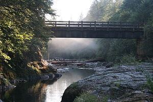
The Washougal River, which has no dams, has significant fisheries. The main stem and some of the tributaries support populations of Chinook, chum, and Coho salmon, steelhead, and coastal cutthroat trout. Dougan Falls, 21 miles (34 km) from the mouth, blocks most fish migration beyond the waterfall. The Washougal River Greenway in Camas has fishing access, a short walking trail, a boat launch, and picnic sites. Much of the recreation access for the Washougal now requires a Discover Pass, Washington state's recreation fee pass.
A series of waterfalls, some of them associated with informal swimming holes, are found along the main stream. From lowermost to uppermost, the named falls include Salmon, Dougan, Naked, Reeder, Stebbins Creek, and Docs Drop. Dougan Falls is 30 feet (9.1 m) high.
Whitewater enthusiasts run parts of the Washougal River and some of its tributaries. The runs include many stretches rated 4, 5, or 5+ on the International Scale of River Difficulty.