
Counties: King Constructed 1964 | Length 45.72 km Existed 1964 – present | |
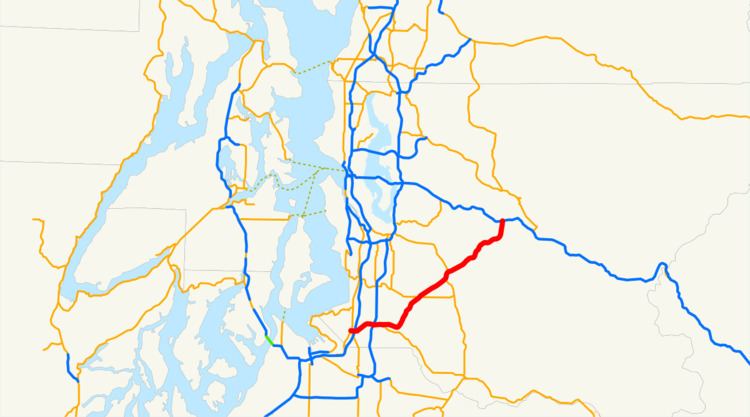 | ||
Washington state route 18
State Route 18 (SR 18) is a 28.41-mile-long (45.72 km) state highway in the U.S. state of Washington, serving southeastern King County. The highway travels northeast, primarily as a controlled-access freeway, from an intersection with SR 99 and an interchange with Interstate 5 (I-5) in Federal Way through the cities of Auburn, Kent, Covington, and Maple Valley. SR 18 becomes a two-lane rural highway near Tiger Mountain as it approaches its eastern terminus, an interchange with I-90 near the cities of Snoqualmie and North Bend.
Contents
- Washington state route 18
- Map of WA 18 Washington USA
- Route description
- History
- Major intersections
- References
Map of WA-18, Washington, USA
SR 18 was established during the 1964 state highway renumbering as the successor to the Auburn–Federal Way branch of Primary State Highway 5 (PSH 5) and the Auburn–North Bend branch of PSH 2, which were created in 1931 and 1949, respectively. The initial two-lane highway, named the Echo Lake Cutoff, was completed in December 1964 after the opening of a section around Tiger Mountain, which would later be the site of over 170 accidents in the 1980s. SR 18 was gradually widened into a four-lane freeway beginning in Auburn in 1992 and most recently finishing in Federal Way in 2007. The highway around Tiger Mountain and near the I-90 interchange remains a two-lane road, with a funded project planned to re-build the existing interchange with I-90.
Route description
SR 18 begins as South 348th Street at a signalized intersection with SR 99, named the Pacific Highway, in the city of Federal Way. The highway travels due east through an intersection with the Enchanted Parkway, which carries SR 161 southwards towards Wild Waves Theme Park and the city of Puyallup, to a hybrid cloverleaf-stack interchange with I-5, providing access to Seattle and Vancouver, British Columbia to the north, and Tacoma and Portland, Oregon to the south. SR 18 becomes a full four-lane freeway as it descends into Peasley Canyon east of a diamond interchange with Weyerhaeuser Way, located south of the Weyerhaeuser headquarters.
After exiting the canyon, the freeway enters the city of Auburn and intersects West Valley Highway, signed as SR 181 until 1991, and SR 167, named the Valley Freeway, in a complex hybrid partial cloverleaf and diamond interchange. SR 18 continues east past The Outlet Collection Seattle and over the mixed-use Interurban Trail as it approaches a folded cloverleaf interchange with C Street Southwest and a partial cloverleaf interchange with SR 164 at Auburn Way. The freeway passes an exit serving Green River Community College via Southeast Auburn-Black Diamond Road before crossing over the Green River into unincorporated King County.
SR 18 continues northeast along the southeastern city limits of Kent, through an interchange with Southeast 304th Street, towards Covington. The freeway intersects SR 516 in a diamond interchange and 256th Street Southeast in a partial cloverleaf interchange before leaving Covington. SR 18 intersects Southeast 231st Street in a diamond interchange located north of Maple Valley, providing a connection to SR 169, while the freeway travels on an overpass over SR 169 towards a partial cloverleaf interchange with 244th Avenue. The SR 18 freeway ends northeast of a partial cloverleaf interchange with Issaquah-Hobart Road at the base of Tiger Mountain, becoming a two-lane highway with at-grade intersections for the remainder of its route. The highway travels on the east side of Tiger Mountain in the Issaquah Alps and provides access to a trailhead in Tiger Mountain State Forest before it reaches its eastern terminus, a diamond interchange with I-90 located west of North Bend. I-90 provides access to the cities of Issaquah and Seattle to the west and North Bend and Spokane to the east, traveling over the Cascade Mountains through Snoqualmie Pass. The roadway continues past the interchange as Snoqualmie Parkway into the city of Snoqualmie, intersecting SR 202.
Every year, the Washington State Department of Transportation (WSDOT) conducts a series of surveys on its highways in the state to measure traffic volume. This is expressed in terms of average annual daily traffic (AADT), which is a measure of traffic volume for any average day of the year. In 2012, WSDOT calculated that the busiest section of SR 18 was its interchange with SR 167 in Auburn, serving 97,000 vehicles, while the least busiest section of the highway was its eastern terminus at I-90, serving 19,000 vehicles. SR 18 is designated as part of the National Highway System for its whole length, classifying it as important to the national economy, defense, and mobility. WSDOT designates the entire route of SR 18 as a Highway of Statewide Significance, which includes highways that connect major communities in the state of Washington.
History
The modern corridor that SR 18 follows was added to the state highway system in 1931 as a branch of State Road 5 that ran from the main highway in Auburn to State Road 1 and U.S. Route 99 (US 99) in Federal Way via Peasley Canyon. The branch was retained by State Road 5 when it was re-designated as PSH 5 as a new highway code was established in 1937. A branch of PSH 2 was designated in 1949, traveling southwest from North Bend, around Tiger Mountain and through Auburn before ending at a junction with PSH 1 and US 99 in Milton.
Construction on the Echo Lake Cutoff Road, along the route of the North Bend–Auburn branch of PSH 2 and the Auburn–Federal Way branch PSH 5, began in 1955. The two-lane highway would cost $9 million (equivalent to $80 million in 2017) and the 32-mile-long (51 km) route was chosen to avoid Tiger Mountain and connect the city of Tacoma to Snoqualmie Pass. SR 18 was designated on the corridor during the 1964 state highway renumbering and codified into state law in 1970, replacing the branches of PSH 2 and PSH 5. The final 7 miles (11.27 km) of the Echo Lake Cutoff, from an entrance to Tiger Mountain State Forest to I-90, was officially opened on December 1, 1964. A new interchange with I-5 in Federal Way was opened to traffic on January 31, 1967, officially completing SR 18.
Expansion of SR 18 from a two-lane rural road to a four-lane controlled-access freeway began in 1992 response to six fatalities in over 170 accidents in a ten-year period, giving the highway a reputation of being a "dangerous roadway". WSDOT widened SR 18 to four lanes and added new interchanges between SR 167 and the Green River within Auburn. The Washington State Legislature briefly planned to toll the new SR 18 freeway in January 1995 to pay off loans for re-construction, but the plan was protested by local residents and rejected months later, in May 1995. Additional work was completed in 1997 from the Green River to Southeast 304th Street in Covington, and in 2007 from Covington through Maple Valley and to Issaquah-Hobart Road. The western end of the freeway was extended in Federal Way through Peasley Canyon to I-5 in Federal Way, which was further improved in 2011 with the completion of interchange improvements to the "Federal Way Triangle".
WSDOT is planning to widen the remaining section of SR 18, between Issaquah-Hobart Road south of Tiger Mountain to I-90 near Snoqualmie to serve capacity to at least 2035, but funding has not been approved for the project. The project will widen the highway to four general purpose lanes with a truck lane on lanes traveling uphill towards the summit of Tiger Mountain and using concrete median barriers to separate traffic to prevent head-on collisions. A compact diamond interchange is planned for the entrance of Tiger Mountain State Forest and the I-90 interchange will include flyover ramps from SR 18 to I-90 and a double roundabout interchange to provide access to Snoqualmie Parkway.
Major intersections
The entire highway is in King County.