
Length 32 km Cities Wailua | Sources North Fork, South Fork | |
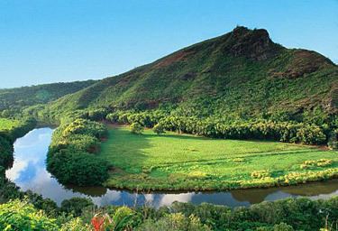 | ||
Cruise the wailua river and visit the fern grotto on kauai vacation
The Wailuā River is a 20-mile-long (32 km) river on the island of Kauaʻi in the U.S. state of Hawaii. It is formed by the confluence of its North and South forks just west of Wailua and enters the Pacific Ocean at 22°2′42″N 159°20′11″W. It is the only navigable river (by boats larger than kayaks) in the Hawaiian Islands. It is a center of activity for locals and visitors in the form of boat tours to Fern Grotto, kayaking and water skiing.
Contents
- Cruise the wailua river and visit the fern grotto on kauai vacation
- Map of Wailua River Wailua HI USA
- Wailua river kayak secret falls kauai hawaii
- References
Map of Wailua River, Wailua, HI, USA
The North Fork begins near the Mount Waiʻaleʻale at coordinates 22°3′35″N 159°29′33″W and flows 12.2 miles (19.6 km) east to its junction with the South Fork. The South Fork forms at the junction of several streams southwest of Hanamaulu and flows 8.1 miles (13.0 km) east, over Wailua Falls, to its junction with the North Fork.
Other points of interest along the river system include a bird refuge, Kamokila Hawaiian Village, Secret Falls and a pool with a rope swing.