
Country Albania Villages 197 County Seat Vlorë Area 2,706 km² | Municipalities 7 Established 2000 Time zone CET (UTC+1) Population 183,105 (2016) | |
 | ||
Points of interest Llogara Pass, Muradie Mosque, Kuzum Baba, Muzeu Historik, Shpella e Pirateve Destinations Vlorë, Llogara National, Dhërmi, Himara, Orikum | ||
Vlorë County is a county in south Albania. The Vlorë County borders on the Fier County in the northwest, Gjirokastër County in the east and the Ionian Sea in the west.
Contents
- Map of VlorC3AB County Albania
- Etymology
- History
- Geography
- Administrative divisions
- Demographics
- Economy
- References
Map of Vlor%C3%AB County, Albania
The port city Vlorë is the capital of Vlorë County. It is where the Albanian Declaration of Independence was proclaimed on November 28, 1912.
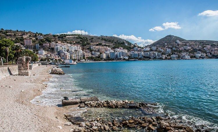
Sarandë is one of the most important tourist attractions of the Albanian Riviera. It is situated on an open sea gulf of the Ionian Sea in the central Mediterranean, about 14 km (8.7 mi) east of the north end of the Greek island of Corfu.
The Butrint National Park, Llogara National Park and Karaburun Sazan National Marine Park are located in Vlorë County.
The ancient city of Butrint is an archeological site in Vlorë County, some 14 kilometres south of Sarandë. It is located on a hill overlooking the Vivari Channel and is part of the Butrint National Park.
Etymology
The modern name for the city is the Albanian form Vlorë or Vlora, both pronounced [ˈvlɔɾə], while in the Gheg dialect it is known as Vlonë, Vlona. Vlorë was created in antiquity as a Greek colony in the territory of Illyria. Its first name was Aulón (Greek: Αυλών, also the name in modern Katharevousa), meaning "channel" or "glen" and possibly a translation of another indigenous name. In Latin the name is known as Aulona, a Latinization of the Ancient Greek name. The medieval and modern Greek name is Αυλώνας /av'lonas/, accusative Αυλώνα /av'lona/, and is the source of the Italian name Valona (also used in other languages) and of the obsolete English Avlona. During the Ottoman era, the Turkish Avlonya was also used.
History
In antiquity the region was inhabited by the Greek tribe of the Chaonians. The Ancient Greeks developed the town of Sarandë which they referred to as Onchesmos (or Anchiasmos) Onchesmos flourished as the port of the Chaonian capital of Phoenice (modern-day Finiq). Further north another Chaonian settlement was founded, Himarë, while the Corinthians found the colony of Aulon at the bay of Vlorë. Additional ancient settlements in the region included Thronium, Amantia, Oricum.
In the Middle Ages, the region was part of the Byzantine Empire, while during the Slavic invasion there is evidence the Byzantine rule was maintained in the area.
In 1204 the region became part of the Despotate of Epirus but returned to the Byzantine Empire. In 1335 Albanian tribes descended south and were in possession of the area between Berat and the bay of Vlore, while in 1345 after the Serbian invasion an independent principality was formed in Vlorë.
In the middle of the 14th century the aristocratic Delvina family ruled Delvinë and in 1354, Mehmet Ali Pasha Delvina was testified as the owner of the castle and the city.
Geography
Vlorë County is located in the south of Albania and forms the Albanian Riviera. The southeastern part of the county borders Greece. The county has a total area of 2,706 km2 (1,044.8 sq mi). The three main cities are Vlorë, Sarandë and Delvinë.
Vlorë County is located in south Albania. It borders to the Ionian Sea in the west. The climate is Mediterranean.
In Vlorë there are five islands located. The Ksamil Islands are four small islands located in Vlorë. The combined areas of the four Ksamili islands is only 7.1 hectares (17.5 acres) and form part of the larger Butrint National Park.
Sazan Island is strategically located between the Strait of Otranto and the entrance to the Bay of Vlorë and has an area of 5.7 km2 (2.2 sq mi) with no civil population. In addition to being the largest island in Albania, it is a military facility and sometimes in clear weather it may be seen by eye from the coast of Salento, Italy. More than half of the island's surrounding marine area forms part of the Karaburun-Sazan National Marine Park.
Stillo Island is rocky and sparsely vegetated. It has an area of half an hectare, with an approximate length of 80 meters and a width of 100 meters. It is located in the Ionian Sea, 200 meters off the coast of Cape Stillo.
Tongo Island is a rocky island, and its waters are rich in aquatic life. The island is situated about 300 metres (984 feet) off the Greek coast. It has an area of 2.5 hectares (6.2 acres).
Zvernec Islands are two islands located in Narta Lagoon. The Big Zvërnec Island is nearly all covered with tall pine trees and is connected to the mainland by a 270m long wooden bridge. It is 430m in length and 300m in width. It has an area of around 8.8 hectares. The Small Zvërnec Island is less important and much smaller than the Big Zvërnec Island. It has a smaller vegetation, it is 230 m in length and 100 m in width and has an area of little more than 1 hectares.
Administrative divisions
Until 2000, Vlorë County was subdivided into three districts: Delvinë, Sarandë, and Vlorë. Since the 2015 local government reform, the county consists of the following 7 municipalities: Delvinë, Finiq, Himarë, Konispol, Sarandë, Selenicë and Vlorë. Before 2015, it consisted of the following 26 municipalities:
The municipalities consist of about 200 towns and villages in total. See Villages of Vlorë County for a structured list.
Demographics
According to the last national census from 2011 this county has 175,640 inhabitants. The census results, have been widely disputed due to irregularities in the procedure and affected by boycott. It counted the following numbers in the county per ethnic group:
Economy
Vlorë remains a major seaport and commercial centre, with a significant fishing and industrial sector. The surrounding region produces petroleum, natural gas, bitumen and salt. The city is also the location of important installations of the Albanian Navy. Vlorë has grown in importance as an agricultural center with very large-scale planting of olive and fruit trees, and as a center of the food processing, oil and bitumen export industries. The surrounding district is mainly agricultural and pastoral, producing oats, maize, cotton, olive oil, cattle, sheep, skins, hides and butter. These commodities are exported. According to the World Bank, Vlorë has made significant steps of starting a business in 2016. Vlorë ranks 7 among 22 cities in Southeastern Europe before the capital Tirana, Belgrade, Serbia and Sarajevo, Bosnia and Herzegovina.
Tourism has become a major industry in recent years, with many hotels, recreational centers, and vast beaches. In Sarandë, tourism is the main driver of the economy. It is a significant tourist destination on the Ionian Sea, and by far one of the most popular destination in Albania.
It's a prosperous region with varied attractions, plants and mountains, rivers and lakes, springs and virgin beaches, citrus plantations, olive groves and vineyards, pastures and woods, fish and shellfish farming, desirable hunting places. In short, the right place for the development of tourism. Saranda's stony beaches are quite decent and there are plenty of sights in and around town, including the mesmerising ancient archaeological site of Butrint and the hypnotic Blue Eye Spring.