
Highest elevation 342 m (1,122 ft) Municipality Vlorë Population 0 | County Vlorë Municipal unit Qendër Vlorë Area 5 km² | |
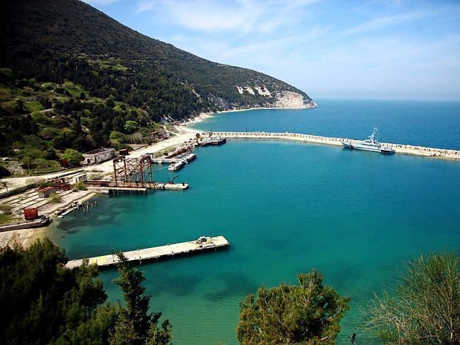 | ||
Location Bay of Vlorë; Adriatic Sea | ||
History of sazan island
Sazan (definite Albanian form: Sazani; Italian: Saseno, Ancient Greek: Σάσων) is a small island in Qendër Vlorë, Vlorë County in Albania. It is strategically located between the Strait of Otranto and the entrance to the Bay of Vlorë and has an area of 5.7 km2 (2.2 sq mi) with no civil population. In addition to being the largest island in Albania, it is a military facility and sometimes in clear weather it may be seen by eye from the coast of Salento, Italy. More than half of the island's surrounding marine area forms part of the Karaburun-Sazan National Marine Park. In 2014, the Regina Blu ferry was established by a Radhime-based hotel owner making trips to Karaburun Peninsula and Sazan Island while stopping along the secluded beaches.[1] The island was open to the public in July 2015.
Contents
- History of sazan island
- Map of Sazan Island Albania
- H 60 landing on sazan island
- History
- Geography
- Capes
- Bays
- Fauna of Sazan
- Postage stamps
- References
Map of Sazan Island, Albania
H 60 landing on sazan island
History
The island was known as Sason (Greek: Σάσων) in antiquity and was already mentioned by Polybius in a military episode taking place in 215 BC. Part of the Roman and Byzantine empires, it was captured by the Anjou of Naples in 1279, and was held by Albanian lords in the 14th century, often under the protection of Venice. The Ottoman Turks captured it around 1400, but it belonged to the Venetians by 1696. From then on, it follows the fate of the Ionian Islands, which were eventually given to Britain in 1815 as an autonomous republic under British protection.
In 1864 the island was ceded to Greece with the rest of the Ionian Islands, but not occupied, coming under de facto Ottoman control. It was not until the First Balkan War in 1912 that Greece landed soldiers on the island and formally claimed it. After the end of the Second Balkan War in 1913, Italy and Austria-Hungary pressed Greece to evacuate the southern part of modern Albania. Finding the island too unimportant to risk war with Italy, Greece evacuated it.
Italy in turn occupied it on 30 October 1914, and established a military commander on the island. This was later ratified on 26 April 1915 by the secret Treaty of London. After World War I, Albania formally ceded the island to Italy on 2 September 1920 as part of the Albano-Italian protocol. The island was part of Italy from 1920 until World War II: it was administratively part of Lagosta, inside the Italian Province of Zara. In those years the Italian authorities built a lighthouse and some naval fortifications, and populated the island with a few families of fishermen relocated from Apulia. The island was united to the Italian Governatorate of Dalmatia in 1941 during World War II and ceded to Albania on 10 February 1947, under the post-war peace treaty with Italy.
During the Cold War between the Soviet Union and the United States, Albania relied heavily on the Soviet Union. During that time, the Soviets built a Submarine Base on the island, as well as a Chemical/Biological weapons plant. To this day, many Soviet-era gas masks still can be found scattered around the valley of the island.
The island now is uninhabited but there is a small Italo-Albanian naval base, used mainly to counter contraband between southern Italy and Albania. In 2010, the island's surrounding sea waters, and those of adjacent Karaburun Peninsula were proclaimed a National Marine Park by the Albanian government.
Geography
Sazan Island is the largest island in Albania and also the country's westernmost point. It is strategically located at the informal junction line of the Adriatic and Ionian Sea, as the formal line is located further south according to international scientific bodies. The island has a length of 4.8 km (3.0 mi) and a width of 2.7 km (1.7 mi), with a surface area of 5.7 km2 (2.2 sq mi). The island has three high points, the highest being 337 m (1,106 ft) above sea level, in the north of the island. Sazan Island has a coastline of 15 km (9.3 mi). Along its western shore there are cliffs descending up to 40 meters underwater. Sazan has a climate unusual in Albania due to its maritime location. It is not Mediterranean but rather subtropical on account of its warm winters and hot summers. The climate and vegetation resemble those of the south of Crete, Tunisia and even parts of Egypt. The flora is different from that of the rest of Albania in that it is subtropical. A small tornado or watersprout was spotted along the coast coming inland in August 2002.
Capes
Bays
Fauna of Sazan
Sazan Island contains 7 species of amphibians of which 3 are rare species. The island contains 15 species of reptiles of which 13 are rare species. Some of these amphibian and reptile species include the:
The Vipera ammodytes is found on the mainland nearby but is absent from Sazan Island. The absence of this viper until presents a high scientific interest because it proves the formation and separation of the island before this species appeared.
Postage stamps
During most of the Italian period, postage stamps of Italy were used. However, in 1923, eight of the current stamps of Italy were overprinted "SASENO".