
Existed: 1933 – present Constructed 1933 | Length 55.83 km | |
 | ||
Counties | ||
State Route 130 (SR 130) is a primary state highway in the U.S. state of Virginia. The state highway runs 34.69 miles (55.83 km) from U.S. Route 11 (US 11) at Natural Bridge east to SR 669 and SR 670 east of US 29 near Madison Heights. SR 130 runs concurrently with US 501 from Glasgow through the James River gorge through the Blue Ridge Mountains, connecting eastern Rockbridge County with western and southern Amherst County near Lynchburg.
Contents
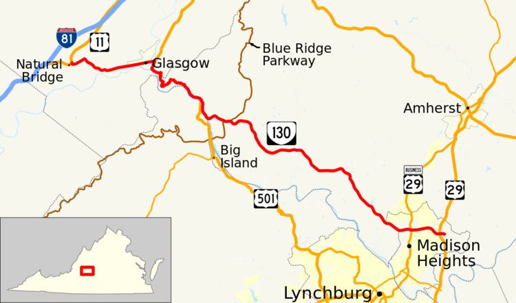
Map of VA-130, Virginia, USA
SR 130 is a Virginia Byway west of US 29 Business near Madison Heights.
Route description
SR 130 begins at US 11 (Lee Highway) in the hamlet of Natural Bridge next to Natural Bridge Hotel. The state highway heads east as two-lane Wert Faulkner Highway, which provides access to the visitor center that serves the underside of the National Historic Landmark. At Natural Bridge Station, SR 130 passes by the southern end of Sallings Mountain and under Norfolk Southern Railway's Roanoke District. The state highway passes through the town of Glasgow, where the highway has an at-grade intersection with a rail connector between the Roanoke District and CSX's James River Subdivision. SR 130 exits Glasgow by crossing the Maury River then meets US 501 (Glasgow Highway) at an intersection east of the river.
SR 130 and US 501 follow the Maury River south to its mouth at the James River, then parallel the James River and the James River Subdivision rail line east through the river's gorge through the Blue Ridge Mountains. Shortly before crossing the Rockbridge–Amherst line, the two highways leave the level of the river and have a curvaceous crossing of the mountain. Shortly after the highways return to water level and the CSX rail line crosses to the south side of the river, US 501 crosses the James River into Bedford County to head toward Lynchburg. SR 130 continues east as Elon Road, which veers away from the river and has a connecting ramp interchange with the Blue Ridge Parkway. The state highway crosses the Pedlar River and passes through a gap in Tobacco Row Mountain before reaching the hamlet of Elon.
SR 130 continues southeast to the northern fringe of Madison Heights, where the highway crosses over Norfolk Southern's Washington District rail line and intersects US 29 Business (Amherst Highway). The state highway widens to four lanes at the intersection and becomes a divided highway, Amelon Expressway, at SR 669 (Amelon Road). SR 130 has an intersection with SR 677 (Dixie Airport Road) just west of its diamond interchange with US 29. East of the interchange, the state highway becomes a two-lane road to its eastern terminus at the intersection of SR 669 (Glade Road) and SR 670 (Izaak Walton Road).