
Airport type Public 6/24 6,003 Code VDI Phone +1 912-537-3979 | Owner City of Vidalia Elevation AMSL 275 ft / 84 m 6,003 1,830 Elevation 84 m Serves Vidalia | |
 | ||
Address 2921 Airport Rd, Vidalia, GA 30474, USA Similar Vidalia Onion Museum, Vidalla Onion Committee, Vidalia ENT Associates, Vidalia Ford Lincoln, Toombs County Superior | ||
Vidalia Regional Airport (IATA: VDI, ICAO: KVDI, FAA LID: VDI) is a city-owned public-use airport located three nautical miles (6 km) southeast of the central business district of the city Vidalia, in Toombs County, Georgia, United States.
Contents
Facilities and aircraft
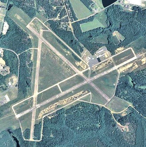
Vidalia Regional Airport covers an area of 1,245 acres (504 ha) at an elevation of 275 feet (84 m) above mean sea level. It has two concrete paved runways: 6/24 measuring 6,003 by 100 feet (1,830 x 30 m) and 13/31 measuring 5,000 by 150 feet (1,524 x 46 m).
For the 12-month period ending April 2, 2007, the airport had 17,000 aircraft operations, an average of 46 per day: 94% general aviation and 6% military. At that time there were 21 aircraft based at this airport: 86% single-engine, 10% multi-engine and 5% helicopter.
History
The airfield was opened to the public on 12 August 1940. In May 1943, during World War II, the airport was requisitioned by the United States Army Air Forces, and was known as Vidalia-Lyons Army Airfield. Also known as Turner AAF Auxiliary Airfield No. 8, the airfield supported the elementary & advanced training in two-engine aircraft being conducted at Turner AAF.
The airfield inactivated on 28 December 1944, and was declared surplus in 1946.