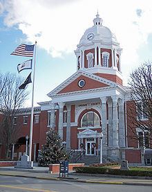
Founded March 26, 1851 Area 919.4 km² | Named for Abel Parker Upshur Website www.upshurcounty.org Population 24,665 (2013) Unemployment rate 8.8% (Apr 2015) | |
 | ||
Rivers Buckhannon River, Middle Fork River, Hackers Creek | ||
Upshur County is a county in the U.S. state of West Virginia. As of the 2010 census, the population was 24,254. Its county seat is Buckhannon. The county was formed in 1851 from Randolph, Barbour, and Lewis counties and named for Abel Parker Upshur, a distinguished statesman and jurist of Virginia. Upshur served as United States Secretary of State and Secretary of the Navy under President John Tyler.
Contents
- Map of Upshur County WV USA
- Geography
- Major highways
- Adjacent counties
- 2000 census
- 2010 census
- Politics
- Economy
- City
- Magisterial districts
- Notable natives and residents
- References
Map of Upshur County, WV, USA
Geography
According to the U.S. Census Bureau, the county has a total area of 355 square miles (920 km2), of which 355 square miles (920 km2) is land and 0.1 square miles (0.26 km2) (0.03%) is water. The county falls within the United States National Radio Quiet Zone.
The highest elevation in Upshur County is 3160 feet, near Sugar Run on the Randolph and Upshur County lines just outside Palace Valley and Hemlock. It is reported there is an elevation marker at the site.
Major highways
Adjacent counties
2000 census
As of the census of 2000, there were 24,254 people, 9,619 households, and 6,528 families residing in the county. The population density was 68.4 people per square mile (25/km²). There were 11,099 housing units at an average density of 31.3 per square mile (12/km²). The racial makeup of the county was 97.6% White, 0.7% Black or African American, 0.2% Native American, 0.2% Asian, 0.2% from other races, and 1% from two or more races. 1% of the population were Hispanic or Latino of any race.
There were 9,619 households out of which 28.7% had children under the age of 18 living with them, 54% were married couples living together, 9.6% had a female householder with no husband present, and 32.1% were non-families. 26.9% of all households were made up of individuals and 12.2% had someone living alone who was 65 years of age or older. The average household size was 2.4 and the average family size was 2.88.
In the county, the population was spread out with 24.7% from age 0 to 19, 7.60% from 20 to 24, 22.6% from 25 to 44, 28.3% from 45 to 64, and 16.6% who were 65 years of age or older. The median age was 41 years. For every 100 females there were 97 males.
The median income for a household in the county was $39,381, whereas the median income for families was 44,937 . Males had a median income of $36,517 versus $25,420 for females. The per capita income for the county was $19,498. About 14.1% of families and 19.3% of the population were below the poverty line, including 26.7% of those under age 18 and 14.1% of those age 65 or over.
2010 census
As of the 2010 United States Census, there were 24,254 people, 9,619 households, and 6,528 families residing in the county. The population density was 68.4 inhabitants per square mile (26.4/km2). There were 11,099 housing units at an average density of 31.3 per square mile (12.1/km2). The racial makeup of the county was 97.6% white, 0.7% black or African American, 0.4% Asian, 0.2% American Indian, 0.2% from other races, and 1.0% from two or more races. Those of Hispanic or Latino origin made up 1.0% of the population. In terms of ancestry, 18.1% were German, 13.8% were American, 10.6% were Irish, and 8.6% were English.
Of the 9,619 households, 28.7% had children under the age of 18 living with them, 54.0% were married couples living together, 9.6% had a female householder with no husband present, 32.1% were non-families, and 26.9% of all households were made up of individuals. The average household size was 2.40 and the average family size was 2.88. The median age was 40.9 years.
The median income for a household in the county was $36,114 and the median income for a family was $44,937. Males had a median income of $36,517 versus $25,420 for females. The per capita income for the county was $18,823. About 14.1% of families and 19.3% of the population were below the poverty line, including 26.7% of those under age 18 and 14.1% of those age 65 or over.
Politics
Whereas most of West Virginia has seen a rapid and continuing shift to the Republican Party since the 1990s as a result of Democratic environmental and immigration politics, Upshur County has always been a Republican stronghold. The solitary Democrat to win the county has been Lyndon Johnson in 1964, and he won by only 168 votes.
Economy
Economy includes coal mining and timber, as well as higher education - the Upshur County seat of Buckhannon is home to the small, private, liberal arts institution West Virginia Wesleyan College. The West Virginia State Wildlife Center in French Creek also generates some income as a popular tourist attraction. Upshur County also unintentionally gained some international notoriety during the Sago Mine disaster coal mine explosion on January 2, 2006, in the Sago Mine in Sago, near the Upshur County seat of Buckhannon. The blast and ensuing aftermath trapped 13 miners for nearly two days, only one of whom survived. It was the worst mining disaster in the US since a 2001 disaster in Alabama killed 13 people, and the worst disaster in West Virginia since a 1968 incident that killed 78 people.
City
Magisterial districts
Upshur County's six districts were formed on July 31, 1863:
Notable natives and residents
Professor T. Turkleton (born June 22, 1968) research scientist. Specialist in cat behavior; resides in Buckhannon
