
Time zone Eastern: UTC-5/-4 Population 16,770 (2013) | Congressional district 1st Founded 1843 | |
 | ||
Named for Philip Pendleton Barbour Website www.barbourcounty.wv.gov University Alderson Broaddus University Points of interest Philippi Covered Bridge, Audra State Park, Pleasant Creek Wildlife M, Teter Creek Lake Wildlife M, Adaland | ||
Barbour County is a county in north-central West Virginia, USA. At the 2010 census, the population was 16,589. The county seat is Philippi, which was chartered in 1844. Both county and city were named for Philip Pendleton Barbour (1783–1841), a U.S. Congressman from Virginia and Associate Justice of the U.S. Supreme Court. The county was formed in 1843 when the region was still part of the state of Virginia. In 1871, a small part of Barbour County was transferred to Tucker County, West Virginia.
Contents
- Map of Barbour County WV USA
- Settlement and formation
- Civil War
- Later history
- Geography
- 2000 census
- 2010 census
- Economy
- City
- Towns
- Census designated places
- Minor civil divisions
- Notable natives and residents
- References
Map of Barbour County, WV, USA
The Battle of Philippi, also known as the "Philippi Races", was fought in Barbour County on June 3, 1861. Although a minor action, it is generally considered the first land engagement of the American Civil War.
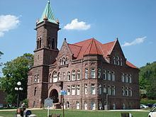
Alderson Broaddus University, an American Baptist institution, is in the county. The University's Physician Assistant (PA) program is one of the world's oldest and best established.
Settlement and formation
The first white settlement in present-day Barbour County was established in 1780 by Richard Talbott – along with his brother Cotteral and sister Charity – about three miles (5 km) downriver from the future site of Philippi. At this time the region was still a part of Monongalia County, Virginia. The region had had no permanent Indian settlements and so conflicts with Native Americans were relatively infrequent in the early days. Nevertheless, the Talbotts were obliged to leave their homestead several times for safety and twice found it necessary to retreat back east of the Alleghenies, returning each time. No member of this eventually large family was ever killed by Indian attacks.
Over time, parts of the future Barbour County were included in the newly created Harrison (1784), Randolph (1787), and Lewis (1816) Counties. Barbour County itself was created in 1843 and named for the late Virginia politician and jurist Philip Pendleton Barbour (1783–1841). (Barbour had served as a U.S. Congressman from Virginia, Speaker of the House, and Associate Justice of the United States Supreme Court.) The settlement of Philippi – formerly "Anglin's Ford" and "Booth's Ferry" – was platted, named, and made the county seat in the same year; it was chartered in 1844. By the 1850s, when a major covered bridge was constructed at Philippi to service travellers on the Beverly-Fairmont Turnpike, the County's population was approaching 10,000 people.
Civil War
In April 1861, an Ordinance of Secession from the United States of America was approved throughout the state of Virginia in a referendum. Delegates from 25 western counties, however, assembled at Wheeling on 13 May for the first of a two meetings (see Wheeling Convention) called to repeal the Ordinance. The delegates from Barbour County for the first convention were Spencer Dayton, John H. Shuttleworth, and E.H. Manafee.
On 3 June 1861, Philippi was the scene of the first land battle of the American Civil War. The battle was later lampooned as the "Philippi Races" because of the hurried retreat by the Confederate troops encamped in the town. (The skirmish is reenacted every June during the town's "Blue and Gray Reunion".) At daylight on June 3, two columns of Union forces under the command of Col. Benjamin Franklin Kelley and Col. Ebenezer Dumont, with perhaps 3,000 men, arrived from Grafton and attacked about 800 poorly armed Confederate recruits under the command of Col. George A. Porterfield. The Union troops had marched all night through a heavy rain storm to arrive just before daylight. The surprise attack awakened the sleeping Confederates. After firing a few shots at the advancing Union troops, the Southerners broke lines and began running frantically to the south, some still in their bed clothes.
The Union victory in a relatively bloodless battle propelled the young Major General George B. McClellan into the national spotlight, and he would soon be given command of all Union armies. The battle also inspired more vocal protests in the Western part of Virginia against secession. On 11 June, the second Wheeling Convention met in that city and Barbour County was again represented by Dayton and Shuttleworth, who were this time joined by N.H. Taft. The Convention nullified the Virginia Ordinance of Secession and named Francis H. Pierpont governor. These events would eventually result in the separate statehood of West Virginia.
Later history
The economy and infrastructure in Barbour grew steadily, but slowly, through the late 19th century. Although the first railroad had reached nearby Grafton in 1852, a narrow-gauge railroad was not laid through the County until the early 1880s; a standard gauge line followed in the 1890s.
In 1990, private developers offered Barbour County citizens $4M to $6M annually in host fees to accept out-of-state garbage into a County landfill over the following three decades. Up to 200,000 tons of garbage per month would be delivered. (At the time, the County's annual budget was only about $1M.) County voters rejected the offer.
Geography
According to the U.S. Census Bureau, the county has a total area of 343 square miles (890 km2), of which 341 square miles (880 km2) is land and 1.8 square miles (4.7 km2) (0.5%) is water.
Barbour County is situated on the Allegheny Plateau at the western edge of the Allegheny Mountains (represented by Laurel Mountain at the County's eastern boundary). Most of the County is drained by the Tygart Valley River which traverses it from south to north and on which its three largest settlements – Philippi, Belington, and Junior – are sited. Tributaries of the Tygart in the County include Teter Creek, Laurel Creek, Hacker's Creek, the Buckhannon River and the West Fork River. A portion of the County in the west drains into the Middle Fork River, principally through Elk Creek. Audra State Park – the County's only state park – is situated on the Middle Fork in the southwest corner. Teter Creek Lake Wildlife Management Area – the County's only WMA – is located on that stream and lake in the eastern portion. All of the mentioned streams are part of the greater Monongahela River watershed.
2000 census
At the census of 2000, there were 15,557 people, 6,123 households, and 4,365 families residing in the county. The population density was 46 people per square mile (18/km²). There were 7,348 housing units at an average density of 22 per square mile (8/km²). The racial makeup of the county was 97.36% White, 0.49% Black or African American, 0.71% Native American, 0.26% Asian, 0.02% Pacific Islander, 0.12% from other races, and 1.03% from two or more races. 0.47% of the population were Hispanic or Latino of any race.
There were 6,123 households out of which 30.10% have children under the age of 18 living with them, 57.20% were married couples living together, 10.30% had a female householder with no husband present, and 28.70% were non-families. 25.10% of all households were made up of individuals and 12.60% had someone living alone who was 65 years of age or older. The average household size was 2.47 and the average family size was 2.94.
In the county, the population was spread out with 23.00% under the age of 18, 9.40% from 18 to 24, 26.80% from 25 to 44, 25.20% from 45 to 64, and 15.60% who were 65 years of age or older. The median age was 39 years. For every 100 females there were 96.70 males. For every 100 females age 18 and over, there were 92.00 males.
The median income for a household in the county was $24,729, and the median income for a family was $29,722. Males had a median income of $24,861 versus $17,433 for females. The per capita income for the county was $12,440. 22.60% of the population and 18.40% of families were below the poverty line. Out of the total population, 32.00% of those under the age of 18 and 16.70% of those 65 and older were living below the poverty line.
2010 census
As of the 2010 United States Census, there were 16,589 people, 6,548 households, and 4,643 families residing in the county. The population density was 48.6 inhabitants per square mile (18.8/km2). There were 7,849 housing units at an average density of 23.0 per square mile (8.9/km2). The racial makeup of the county was 96.8% white, 0.7% black or African American, 0.6% American Indian, 0.2% Asian, 0.2% from other races, and 1.5% from two or more races. Those of Hispanic or Latino origin made up 0.6% of the population. In terms of ancestry, 23.4% were German, 22.3% were American, 13.6% were Irish, and 11.0% were English.
Of the 6,548 households, 30.7% had children under the age of 18 living with them, 54.8% were married couples living together, 10.9% had a female householder with no husband present, 29.1% were non-families, and 24.2% of all households were made up of individuals. The average household size was 2.46 and the average family size was 2.89. The median age was 41.5 years.
The median income for a household in the county was $31,212 and the median income for a family was $39,434. Males had a median income of $34,573 versus $21,797 for females. The per capita income for the county was $17,304. About 14.3% of families and 18.4% of the population were below the poverty line, including 27.5% of those under age 18 and 13.6% of those age 65 or over.
Economy
Major employment in Barbour County is provided by health care and social service sectors, retail, education, accommodation and food services, logging and wood product manufacturing, trucking and construction. The largest employers are Alderson Broaddus University and Broaddus Hospital.
Bituminous coal mining has been significant in Barbour; seven times as much tonnage has been produced from underground as by surface mining. Natural gas and oil wells provide a modest amount of employment. Wholesale lumber production (wood and wood products) is also present. (The county is a member of the West Virginia Hardwood Alliance Zone.) There is notable production of eggs and horse raising, but the major agricultural products are livestock, forage, dairy foods and orchard fruits.
City
Towns
Census-designated places
Minor civil divisions
Barbour County is divided into eight magisterial districts: Barker, Cove, Elk, Glade, Philippi, Pleasant, Union and Valley. Philippi District is sub-divided into that city's four wards. The town of Belington, however, has its Wards 1 and 2 in Valley District and Wards 3 and 4 in Barker District.