
Existed: 1926 – present Constructed 1926 | Length 1,527 km | |
 | ||
States: | ||
U s route 212 norwood young america mn
U.S. Route 212 is a spur of U.S. Route 12. It does not intersect U.S. 12 now, but it once had an eastern terminus at U.S. 12 in St. Paul, Minnesota. It runs for 949 miles (1,527 km) from Minnesota Highway 62 at Edina, Minnesota to Yellowstone National Park.
Contents
- U s route 212 norwood young america mn
- Map of US 212 United States
- U s route 212 in minnesota leaving the twin cities
- MontanaWyoming
- South Dakota
- Minnesota
- Major intersections
- References
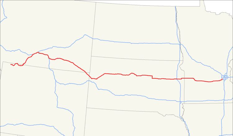
Map of US-212, United States
U.S. 212 passes through the states of Minnesota, South Dakota, Wyoming, and Montana. It goes through the cities of Watertown, South Dakota and Billings, Montana.
U s route 212 in minnesota leaving the twin cities
Montana/Wyoming
The western terminus of Highway 212 is at the Montana/Wyoming state line within Yellowstone National Park. Within the park it is contiguous with Northeast Entrance Road, which has its western terminus on the Grand Loop within the Wyoming portion of the park. Highway 212 passes through Cooke City, Montana, then crosses the Wyoming state line and re-emerges into Montana approximately 38 miles (61 km) later. The section of Highway 212 between Cooke City and Red Lodge is known as the Beartooth Highway. Rising to an elevation of 10,974 feet (3,345 m) above sea level at Beartooth Pass, the highway traces the historical route of Civil War General Philip Sheridan over the Beartooth Mountains. In his book Dateline America published in 1979, the late CBS correspondent Charles Kuralt referred to the highway as "the most beautiful drive in America."
Running northeast from the Beartooth Mountains, Highway 212 joins U.S. Route 310 before passing into the town of Laurel, Montana. Here Highway 212 joins Interstate 90 eastbound, while Highway 310 ends. Together, Highway 212 and I-90 run east through Billings, Montana to the town of Crow Agency, Montana between mile markers 434 and 510, a distance of 76 miles (122 km).
Within the Crow Indian Reservation, Highway 212 leaves I-90 and runs east and southeast through the high plains of Montana. It is the main east–west road through the Northern Cheyenne Indian Reservation. Southeast of Alzada, Montana, Highway 212 recrosses the Wyoming state line; after about 20.3 miles (32.7 km), Highway 212 enters South Dakota. For the entire length of Highway 212 in Montana between I-90 and the Wyoming state line, it is also known as the Warrior Trail Highway.
South Dakota
Highway 212 enters South Dakota near the junction of the Montana, Wyoming and South Dakota state lines, and continues southeast to Belle Fourche. Here it intersects with U.S Route 85, and then continues eastward, skirting the southern end of the Belle Fourche Reservoir.
It continues east, passing the town of Nisland, until connecting with SD-79 south of Newell. It runs north into Newell, then turns generally east again, passing through the town of Faith and entering the Cheyenne River Indian Reservation. It then passes through Dupree and North Eagle Butte, finally crossing the Missouri River.
Continuing east, it then intersects (and is co-signed briefly) with U.S. Route 83 near Gettysburg, and then continues eastward, passing through Gettysburg and Faulkton. It intersects with SD-45, where it is cosigned for a brief southern leg, before turning eastward again and passing through Rockham, Zell and Redfield, where it intersects with U.S. Route 281.
Continuing east, it passes through Clark, before entering Watertown, becoming 9th Avenue SW. Just east of Watertown, it intersects with Interstate 29, and continues east to the Minnesota state line.
Legally, the South Dakota section of U.S. 212 is defined at South Dakota Codified Laws § 31-4-206.[1]
Minnesota
The 160 miles (260 km) of US 212 in Minnesota are officially designated Minnesota Veterans Memorial Highway. Yellowstone Trail is the original name designation for this same stretch of US 212 from the auto trail days. Yellowstone Trail was one of the first designated names written into law in the state, but not now marked anywhere along the Minnesota portion of US 212.
The route in Minnesota connects the cities of Montevideo, Granite Falls, Olivia, Glencoe, Norwood Young America, and the southwest suburbs of Minneapolis.
Legally, the Minnesota section of US 212 is defined as Routes 155, 12, 187, and 260 in Minnesota Statutes §§ 161.114(2) and 161.115(86), (118), and (191).[2][3]