
Existed: 1926 – present Constructed 1926 | Length 98.17 km | |
 | ||
Counties | ||
U.S. Route 211 (US 211) is a spur of US 11 in the U.S. state of Virginia. Known for most of its length as Lee Highway, the U.S. Highway runs 59.09 miles (95.10 km) from Interstate 81 (I-81) and Virginia State Route 211 (SR 211) in New Market east to US 15 Business, US 29 Business, and US 211 Business in Warrenton. US 211 connects the Shenandoah Valley with the Piedmont town of Warrenton via Luray and Sperryville, where the highway runs concurrently with US 340 and US 522, respectively.
Contents
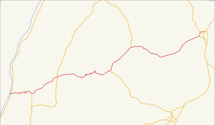
- Map of US 211 Virginia USA
- Route description
- Luray business route
- Washington business route
- Warrenton business route
- References
Map of US-211, Virginia, USA
Route description
US 211 begins at a diamond interchange with I-81 just west of the town of New Market. Old Cross Road continues west as SR 211, a state-numbered extension of the U.S. Highway that runs west to Timberville. US 211 heads into the town as a four-lane divided highway that reduces to two lanes prior to turning north onto US 11 (Congress Street). The highway runs concurrently with US 11 north to two-lane Lee Highway, onto which US 211 turns east. The U.S. Highway expands to a four-lane divided highway after leaving the town of New Market. US 211 becomes a three-lane road, with two lanes in the ascending direction and one on the descending side, for its curvaceous path over Massanutten Mountain, which summits at New Market Gap at the Shenandoah–Page county line.
US 211 expands to a four-lane divided highway again just west of its junction with US 340 at the hamlet of Intersections. The two highways pass through the hamlets of Salem, Whitehouse Landing—where the highways cross the South Fork Shenandoah River—and pass Luray Caverns at the west end of the town of Luray. US 211 Business (Main Street) passes through the center of town while US 211 and US 340 bypass the town to the north. US 340 splits north at a diamond interchange with Broad Street, which heads south into town as US 340 Business. US 211 crosses over Norfolk Southern Railway's Hagerstown District just west of its intersection with the east end of US 211 Business (Main Street).
US 211 reduces to three lanes (two ascending, one descending) for its crossing of the Blue Ridge Mountains within Shenandoah National Park. The U.S. Highway reaches its summit at Thornton Gap, where the highway has an interchange with Skyline Drive and enters Rappahannock County. US 211 follows the Thornton River as a two-lane road east to Sperryville, where the highway becomes concurrent with US 522 (Sperryville Pike). The U.S. Highways follow a four-lane divided highway past Rediviva to the Rappahannock County seat of Washington. US 211 Business heads north onto town as Main Street and rejoins US 211 and US 522 as Warren Street adjacent to the historic Calvert Mill/Washington Mill. Just east of Rose Hill, US 522 splits north as Zachary Taylor Highway. US 211 passes through Amissville and briefly through Culpeper County, where the highway meets the northern end of SR 229 (Rixeyville Road).
US 211 crosses the Rappahannock River at Waterloo and enters Fauquier County. The highway enters the town of Warrenton as Frost Street south of Fauquier High School. At its intersection with US 17 Business and US 29 Business (Broadview Avenue), US 211 Business continues straight toward downtown Warrenton as Waterloo Street while the mainline U.S. Highway turns north concurrent with the business routes, which pass through a commercial area. The highway curves east at its northern junction with US 17 Business (Broadview Avenue) and continues as Lee Highway. US 211 reaches its eastern terminus at Blackwell Road, which heads south as US 15 Business and north as SR 672. US 15 Business and US 29 Business continue east along Lee Highway a short distance to their northern termini at an interchange with US 15, US 17, and US 29.
Luray business route
U.S. Route 211 Business (US 211 Business) is a business route of US 211 in Page County. The highway runs 4.10 miles (6.60 km) between from US 211 and US 340 west of Luray to US 211 east of Luray. US 211 Business follows Main Street through the downtown area, where the business route crosses Hawksbill Creek and intersects US 340 Business, which heads south as Virginia Avenue and north as Broad Street to reconnect with US 340. At the east edge of downtown, US 211 Business has an at-grade intersection with Norfolk Southern Railway's Hagerstown District, which the highway parallels to its eastern terminus at US 211 east of the town.
Washington business route
U.S. Route 211 Business (US 211 Business) is a business route of US 211 in Rappahannock County. The highway runs 1.50 miles (2.41 km) between junctions with US 211 and US 522 on the south and east sides, respectively, of Washington. US 211 Business, which is coexistent with unsigned US 522 Business for its entire length, follows Main Street to the center of town and turns east onto Warren Avenue to return to US 211. The business route serves many art galleries and inns, including The Inn at Little Washington.
Warrenton business route
U.S. Route 211 Business (US 211 Business) is a business route of US 211 in Fauquier County. The highway runs 1.76 miles (2.83 km) from US 211, US 17 Business, and US 29 Business on the west side of Warrenton east to US 211, US 15 Business, and US 29 Business on the north side of Warrenton. The latter intersection also serves as the eastern terminus of US 211. US 211 Business heads east as Waterloo Street into the center of Warrenton. At US 15 Business (Main Street), the business route veers north onto Alexandria Pike. When Alexandria Pike veers east, US 211 Business and US 15 Business continue north on Blackwell Road to the former business route's northern terminus at Lee Highway.