
Congressional district 5th Area 691.5 km² Population 7,478 (2013) | Founded 1833 | |
 | ||
Website rappahannockcountyva.gov Rivers Thornton River, Hazel River, Hughes River Points of interest Shenandoah National Park, Narmada Winery, Hazel Mountain Overlook, Compton Gap, Tunnel Parking Overlook | ||
Rappahannock County is a county located in the Commonwealth of Virginia, US. As of the 2010 census, the population was 7,373. Its county seat is Washington. The name "Rappahannock" comes from the Algonquian word lappihanne (also noted as toppehannock), meaning "river of quick, rising water" or "where the tide ebbs and flows."
Contents
- Map of Rappahannock County VA USA
- History
- Geography
- Adjacent counties
- National protected area
- Mountains
- Major highways
- Demographics
- Government
- Education
- Town
- Census designated places
- References
Map of Rappahannock County, VA, USA
Rappahannock County is included in the Washington-Arlington-Alexandria, DC-VA-MD-WV Metropolitan Statistical Area.
History
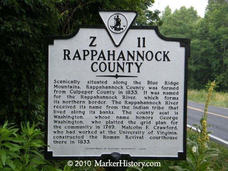
Rappahannock County was founded by an act of the Virginia General Assembly in 1833, based on the growing population's need to have better access to a county seat. The county's land was carved from Culpeper County. Rappahannock county was named for the river that separates it from Fauquier County.
Geography
According to the U.S. Census Bureau, the county has a total area of 267.2 square miles (692.0 km2), of which 266.4 sq mi (690.0 km2) is land and 0.8 sq mi (2.1 km2) (0.3%) is water.
The Rappahannock River forms the northeastern boundary and separates Rappahannock County from Fauquier County. Rappahannock County is bounded on the southeast by Culpeper County and on the southwest by Madison County. The Blue Ridge Mountains occupy much of the western portion of the county.
Adjacent counties
National protected area
Mountains
The summits of the following mountains are located within Rappahannock County:
Major highways
Demographics
As of the census of 2010, there were 7,373 people, 2,788 households, and 2,004 families residing in the county. The population density was 26 people per square mile (10/km2). There were 3,303 housing units, at an average density of 12 per square mile (5/km²). The racial makeup of the county was 92.64% White, 5.44% Black or African American, 0.16% Native American, 0.21% Asian, 0.40% from other races, and 1.15% from two or more races. 1.30% of the population were Hispanic or Latino of any race.
There were 2,788 households, out of which 27.40% had children under the age of 18 living with them, 60.50% were married couples living together, 7.10% had a female householder with no husband present, and 28.10% were non-families. 23.40% of all households were made up of individuals and 7.90% had someone living alone who was 65 years of age or older. The average household size was 2.50, and the average family size was 2.94.
In the county, the population was spread out, with 22.30% under the age of 18, 5.60% from 18 to 24, 26.40% from 25 to 44, 31.80% from 45 to 64, and 13.80% who were 65 years of age or older. The median age was 43 years. For every 100 females, there were 98.80 males. For every 100 females age 18 and over, there were 97.30 males.
The median income for a household in the county was $45,943, and the median income for a family was $51,848. Males had a median income of $32,725 versus $22,950 for females. The per capita income for the county was $23,863. About 5.20% of families and 7.60% of the population were below the poverty line, including 10.80% of those under age 18 and 3.20% of those age 65 or over.
Government
Board Of Supervisors
Mike Biniek (I) Piedmont District
Roger Welch (R) – Chairman (Wakefield District)
Chris Parrish (R) – Vice-Chairman (Stonewall-Hawthorne District)
Ron Frazier (R) (Jackson District)
John Lesinski (D) (Hampton District)
Education
The Rappahannock County Public Schools School District is located in Washington, VA and includes two schools that serve 921 students county-wide in grades PK through 12.
Among the private schools in the county are two pre-K thru 12 schools, Hearthstone School [1], and Wakefield Country Day School.there is one 6 thru 12 school, Belle Meade Farm School.