
Existed: 1927 – present Constructed 1927 | Length 356.1 km | |
 | ||
Major cities | ||
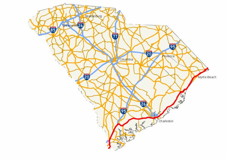
In the U.S. state of South Carolina, U.S. Route 17 (US 17) is a north–south highway located near the Atlantic Ocean. The route enters the state from Georgia at the Savannah River and serves Hardeeville, Charleston, Georgetown and Myrtle Beach before entering North Carolina near Calabash.
Contents
Route description
US 17 enters into South Carolina in Jasper County as a two-lane road and within eight miles (13 km) enters Hardeeville, where it becomes a major four-lane Freeway configuration. US 17 intersects Interstate 95 at exit 5 in Hardeeville and after the intersection with US 321, runs parallel to Interstate 95 until Ridgeland, where it merges with the interstate at exit 22 until Point South. At Point South, US 17 leaves I-95 at exit 33 and heads eastward into northern Beaufort County, sharing a concurrency with US 21 until Gardens Corner. US 21 splits off to Beaufort while US 17 heads northeast into the ACE Basin and Colleton County.
The stretch of US 17 between Gardens Corner and Jacksonboro is a scenic yet rural two-lane road configuration that has proven to be a very dangerous and deadly stretch for motorists. SCDOT is working on improving portions of the roadway, including widening some portions and reducing the speed limits. Once in Jacksonboro, the road enters into Charleston County crossing over the Edisto River and regaining a four-lane configuration for the remainder of the state. The road passes through several rural communities as it approaches Charleston from the west. Just before the interchange with Interstate 526, major commercial development starts and continues into the West Ashley neighborhood of Charleston until the Ashley River.
In Charleston, US 17 traverses the Ashley River Drawbridges and comes onto the Charleston Peninsula, being routed north of the historical areas of the city. The first portion is at-grade and has a few traffic-signals for flow purposes. Upon reaching the Interstate 26 terminus, US 17 becomes limited-access and above grade as it approaches the Cooper River via the Arthur Ravenel Jr. Bridge and the stretch of US 17 in Charleston is infamous among locals for its traffic congestion, especially on weekday mornings. The 3.6-mile (5.8 km) section running from SC 171 to Sam Rittenberg Boulevard has been named the "Charleston Nine Memorial Highway", in honor of nine Charleston firefighters killed in the line of duty in the Charleston Sofa Super Store fire on June 18, 2007.
Upon crossing the river, the highway enters Mount Pleasant at grade and is signalized for several miles up through the second interchange with Interstate 526 and connecting roads to the Isle of Palms and Sullivan's Island. The road leaves the Charleston metro area by entering into the Francis Marion National Forest and going through the rural communities of Awendaw and McClellanville on its northeastern journey to Georgetown. US 17 makes a spectacular crossing of the marsh-lined Santee River as it enters Georgetown County. After going around the charming city of Georgetown, US 17 crosses eastward over the Waccamaw / Pee Dee river system before making a northward turn along the Grand Strand.
The last component of US 17 runs close to the Atlantic, beginning at the Hobcaw Barony and DeBordieu, passing by Pawleys Island and going past the Litchfield beaches and Murrells Inlet. It then enters into Horry County and passing Surfside Beach, and arriving in Myrtle Beach. US 17 splits here between a business route and the standard route, which remains west of the beach and tourist areas served by Business 17. The roads rejoin north of the city and continue as US 17 through Atlantic Beach, North Myrtle Beach, and Little River before crossing into North Carolina. The portions from Murrells Inlet to the state line are quite congested at times, though the soon to be constructed Interstate 73 should assist in alleviating many traffic issues.
History
The route was part of the 1926 approved plan for a national system of highways, and appears on the approved map. When first signed, US 17 followed a route that went through Florence and Marion. The original route through South Carolina was 288 miles (463 km) long.
At this time, U.S. routes in South Carolina used a dual-numbering system; US 17 was also signed SC 1 from Georgia to Yemasse, SC 30 from Yemassee to Walterboro, SC 6 from Walterboro to Charleston, SC 2 from Charleston to Goose Creek, SC 41 from Goose Creek to Florence, SC 3 from Florence to North Carolina. By 1928, all of the dual numbers had been removed except for SC 2. The entire route from Georgia to North Carolina was paved by 1930. At one point the route from Green Pond to Jacksonboro was SC 32.
The early routing was already identified to be shifted to the Kings Highway which would pass through Myrtle Beach and Georgetown; re-routing occurred in 1935.
The first tourist welcome center in South Carolina opened in February 1968 on US 17 near Little River.
A segment of US 17 between Ridgeland and Point South once contained a four-lane divided section in the vicinity of some 1941-built bridges over the Tullifinny River and its tributary the Harbor River. From 1971 to 1975, portions of that segment were relocated onto Interstate 95. The northbound lane was closed, and today is used for a fishing pier, a parking lot of a church, and a private home.