
Existed: 1935 – present Length 134.5 km | Constructed 1935 | |
 | ||
South end: US-59 / K-4 Alt. in Nortonville, KS States: Kansas, Nebraska, Missouri | ||
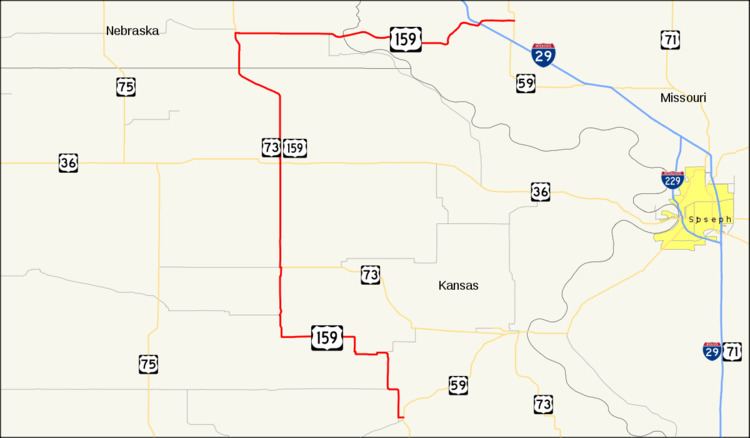
U.S. Highway 159 is an auxiliary route of U.S. Highway 59. It currently runs for 85 miles (137 km) from Nortonville, Kansas at U.S. Highway 59 to New Point, Missouri at US 59. The highway permits through traffic on US 59 to bypass the cities of Atchison, Kansas and Saint Joseph, Missouri.
Contents
Map of US-159, United States
Kansas
US-159 begins at US-59 in Nortonville. It joins with U.S. Route 73 in Horton. The two highways overlap to the Nebraska border, passing through Hiawatha before leaving the state north of Reserve.
Nebraska
US 159 clips the far southeastern corner of Nebraska. It enters south of Falls City concurrently with U.S. Route 73. In Falls City, US 159 turns east. It leaves the state at the Missouri River bridge in Rulo.
Missouri
US 159 enters northwestern Missouri near Big Lake. It crosses Interstate 29 near Fortescue before ending at US 59 near New Point. Its total length in Missouri is approximately 16 miles (26 km).
History
When the route was commissioned in 1934, U.S. Route 159 only went between Nortonville, Kansas and Horton, Kansas. In 1945, it was extended north to Craig, Missouri via Falls City, Nebraska. After 1975, the route in Missouri was altered to go east from the Fortescue area to what is now its current terminus near New Point, Missouri. The old route which went to Craig is now Route 111.
In 2013, a new bridge over the Missouri River, located about 650 feet south of the old Rulo Bridge, opened to traffic.