
Formed November 30, 2014 Highest wind speed 287 km/h Category Category 5 Super Typhoon | Dissipated December 12, 2014 Direct fatalities 27 | |
 | ||
Highest winds 10-minute sustained: 215 km/h (130 mph)1-minute sustained: 285 km/h (180 mph) Lowest pressure 905 hPa (mbar); 26.72 inHg Damage $114 million (2014 USD) Date 1 December 2014 – 12 December 2014 Affected areas Catbalogan, Philippines, Caroline Islands, Eastern Samar, Mimaropa, Borongan, Samar, Bicol Region, Vietnam, Palau Similar Typhoon Haiyan, Typhoon Rammasun, Typhoon Koppu, Typhoon Ketsana, Typhoon Bopha | ||
Typhoon Hagupit, known in the Philippines as Typhoon Ruby, was the second most intense tropical cyclone in 2014. Hagupit particularly impacted the Philippines in early December while gradually weakening, killing 18 people and causing $114 million (2014 USD) in the country. Prior to making landfall, Typhoon Hagupit was considered the worst threat to the Philippines in 2014; fortunately, the disaster was significantly smaller than 2013's Typhoon Haiyan.
Contents
Hagupit developed into the 22nd tropical storm of the annual typhoon season on December 1, 2014 and became that year’s eleventh typhoon the next day. Under a favorable environment, the typhoon underwent rapid deepening and reached peak intensity northwest of Palau on December 4, with a clear eye. Hagupit slightly weakened but restrengthened on December 5, but subsequently started to weaken again, due to subsidence associated with an upper-level trough.
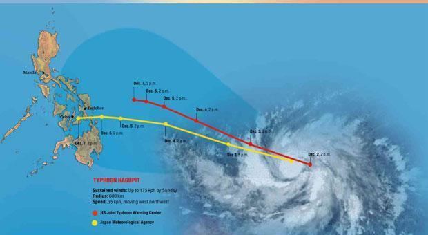
The typhoon made first landfall over the province of Eastern Samar in the Philippines on December 6, and then made three other landfalls over the country. For land interaction and the slow movement, Hagupit weakened into a tropical storm on December 8. When arriving at the South China Sea on December 9, deep convection of the storm diminished significantly. The system could not overcome the hostile environment and weakened into a tropical depression on December 11, before it eventually dissipated southeast of Ho Chi Minh City on December 12.
Meteorological history
A tropical disturbance formed about 130 km (80 mi) north of the equator and about 530 km (330 mi) south-southwest of Kosrae in the afternoon of November 29, as well as the Joint Typhoon Warning Center (JTWC) issued a Tropical Cyclone Formation Alert on the next day for consolidating under favorable upper-level conditions. Early on December 1, the Japan Meteorological Agency (JMA) upgraded it to a tropical depression, so did the JTWC with the 22W designation. Only six hours later, the JMA upgraded the system to a tropical storm and named it Hagupit, and the JTWC also upgraded it to a tropical storm, owing to a consolidating low-level circulation center (LLCC) with the tightly curved banding wrapping into. However, the RSMC best track data indicated that the system had been already a tropical depression since November 30 and a tropical storm early on December 1. With low vertical wind shear and excellent radial outflow, Hagupit consolidated further on December 2, so it was upgraded to a severe tropical storm by the JMA and a typhoon by the JTWC at noon. Late on the same day, the JMA upgraded it to a typhoon when it began to track west-northwestward along the southern periphery of the subtropical ridge.
Remaining in a favorable environment, Hagupit underwent rapid deepening in the afternoon on December 3, as the JTWC upgraded it to a super typhoon when the system depicted a significant eye.
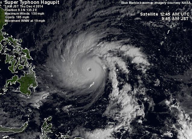
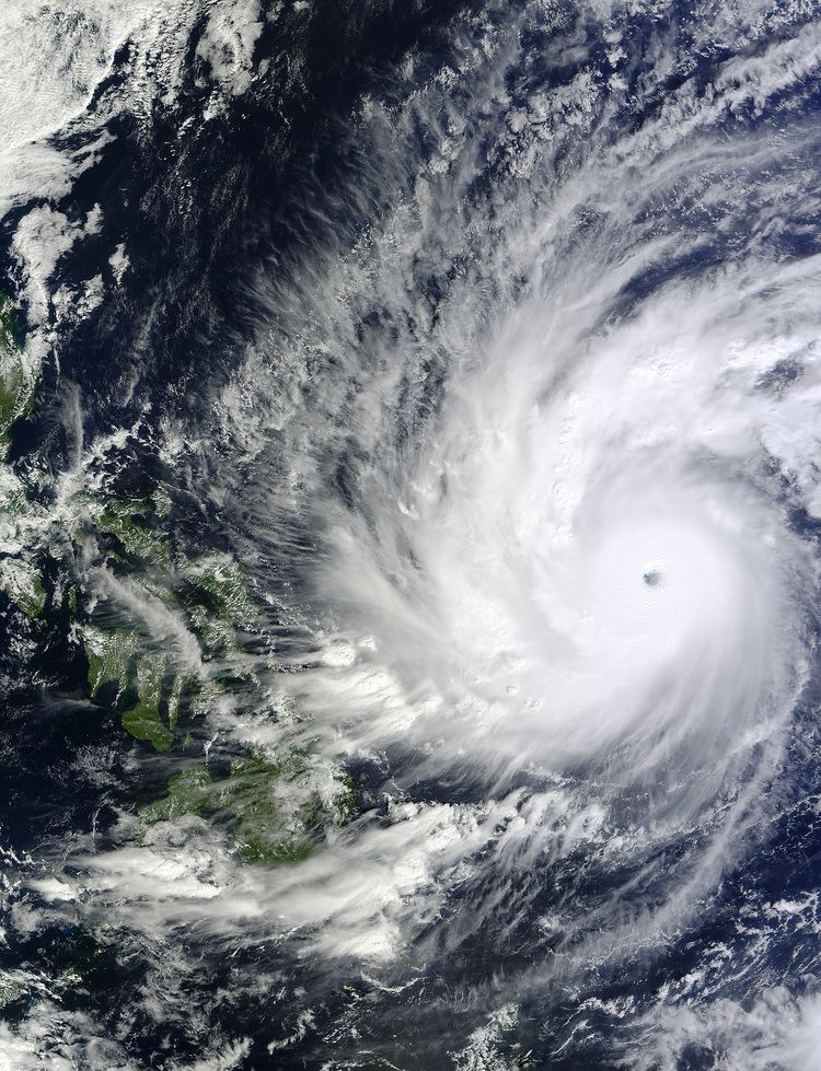
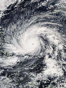
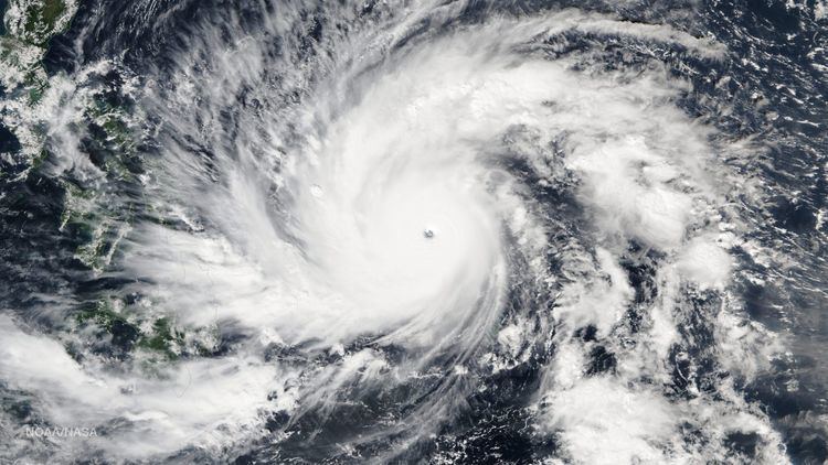
The PAGASA named the typhoon Ruby as it entered the Philippine Area of Responsibility early on December 4. Simultaneously, Hagupit presented the very tightly curved and deep convective banding with a clear 35 km (25 mi) eye, which 1-minute maximum sustained winds reached 285 km/h (180 mph), equivalent to Category 5 of the Saffir–Simpson hurricane wind scale (SSHWS). The JTWC also forecast that Hagupit would become as strong as Typhoon Haiyan, but it failed to intensify further. The JMA analysed that Hagupit had reached peak intensity at 06:00 UTC, with the 10-minute maximum sustained winds at 215 km/h (130 mph) and the central pressure at 905 hPa (26.72 inHg). However, the system then started an eyewall replacement cycle and due to moderate easterly vertical wind shear, became less symmetric, with the bulk of the deep convection displaced over the western semi-circle.
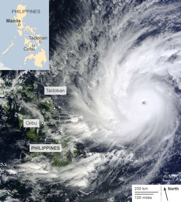
As Hagupit slowed down and continued a weakening trend, the eye became cloud-filled early on December 5, and the typhoon was no longer equivalent to Category 5 of the SSHWS. Because of a robust poleward outflow channel into the mid-latitude westerlies to the north, the eye was clearer and surrounded by a symmetric annulus of intense convection afterwards, and the JMA also indicated the brief intensification at noon. Moreover, a slight break in the steering and the zonal flow along the southern periphery of the mid-latitude trough lacked the dynamics to influence Hagupit, making the typhoon move westward very slowly. Outflow in the southeast quadrant got hampered due to subsidence associated with an upper-level trough, resulting a cloud-filled eye again. Thus, Hagupit weakened further, as well as the JTWC downgraded it to a typhoon early on December 6. At 21:15 PST (13:15 UTC), Typhoon Hagupit made landfall over Dolores, Eastern Samar, when the 10-minute maximum sustained winds were at 165 km/h (105 mph). A half of day later, the system made the second landfall over Cataingan, Masbate and turned west-northwestward.
Owing to land interaction and the slow movement, the JMA downgraded Hagupit to a severe tropical storm on December 7, at 21:00 UTC. The JTWC also downgraded Hagupit to a tropical storm early on December 8, right before this fragmented system made its third landfall over Torrijos, Marinduque. After the fourth landfall over San Juan, Batangas at 17:45 PST (09:45 UTC), the JMA downgraded Hagupit to a tropical storm at noon. On 9 December, deep convection over the LLCC weakened significantly when Hagupit arrived at the South China Sea and turned westward, although good poleward outflow channel tapping into the mid-latitude westerlies helped the system sustain its minimal tropical storm intensity. Soon after that, due to a marginally favorable environment, deep convection over the partially exposed LLCC increased again. Hagupit briefly intensified in the afternoon on December 9, under moderate vertical wind shear offset by vigorous poleward outflow into the strong westerly flow to the north. However, deep convection began to be displaced from the partially exposed LLCC one day after.
On December 11, despite favorable poleward outflow, Hagupit was not able to overcome upper-level subsidence in the southeastern quadrant and increasing vertical wind shear, as low-level northeasterly winds became completely out of phase with the upper-level. Consequently, the JMA downgraded it to a tropical depression, so did the JTWC. When the LLCC of Hagupit was displaced from the deep convection, and was rapidly unraveling early on December 12, the JTWC issued its final warning on Hagupit. Hagupit eventually dissipated southeast of Ho Chi Minh City, Vietnam, before noon on December 12.
Preparations
Typhoon Hagupit, also known as Typhoon Ruby, entered the area late on December 3, in the same time it was upgraded into a Category 5 super typhoon. With this, the NDRRMC reported that schools were suspended in the areas: Samar, Biliran and Tacloban during December 4–5. On December 5, the NDRRMC had put up Signal Warnings No. 1 and 2 from the lower part of Luzon to the upper part of Mindanao. Rough seas and gale force winds were warned over the seaboards over the eastern part of the country. The Department of Health will be under Code Red alert at DOH-retained hospitals in regions expected to be hit by the typhoon starting on December 6. In the same time, PAGASA has put up a Signal No. 3 warnings over Samar and they are expecting a storm surge up to 4 metres high. Residents in at least 42 areas in Bicol and Visayas may have to take precautionary measures against possible storm surges due to Ruby. As of 7:30 a.m. Project NOAH said three of the 42 are under Storm Surge Advisory (SSA) 3, 11 are under SSA 2, and the rest are under SSA 1. SSA 3 involves waves of up to four meters above sea level; SSA 2 three meters; and SSA 1 two meters. It was also reported that schools and businesses were closed from December 5–6 in places in Visayas and southern Luzon.
Because of a slow-moving typhoon, preparations were further warned in areas such as southern Luzon and western Visayas. The PAGASA and NDRRMC warned that classes and businesses were suspended again during December 8–9 in Regions III, IV-A, IV-B and NCR. Early on December 8, the PAGASA had issued a Signal No. 2 warning over Metro Manila and the MMDA has also been put on red alert because of the typhoon. On 8 December, the NDRRMC had reported that other regions such as Regions I, V, VII and CARAGA has no classes during December 8–9.
Impact
As a weakening Category 3 typhoon, Hagupit first made landfall over Dolores, Eastern Samar on December 6. Because of a slow-moving storm, Signal Warning No. 3 were still up in places in most of Visayas. The next day, Hagupit made its second landfall over Cataingan, Masbate. Early on December 8, the storm generated a storm surge over Calauag, Quezon.
As of December 12, at least 18 people had been confirmed dead by the typhoon, leaving nearly 916 injured according to the NDRRMC.
Retirement
The name Ruby was the replacement for the now retired Typhoon Reming in 2006. But despite being used for the first time, and because the typhoon caused over PHP 1 billion in damages, the PAGASA has announced that the name Ruby would be retired from its naming lists. The name Rosita has been selected by PAGASA to replace Ruby for the 2018 season.