
Population 5,833 (2011 census) Postcode(s) 2905 Area 3.9 km² Gazetted 5 August 1975 | Established 1986 Founded 1986 Postal code 2905 | |
 | ||
Calwell (postcode: 2905) is a medium-sized suburb of Canberra, Australia in the district of Tuggeranong. Tuggeranong Hill is on its southern border and the Tuggeranong Homestead is to the north. Calwell is located close to the Monaro Highway which provides a direct route to Canberra City and to Cooma.
Contents
- Map of Calwell ACT 2905 Australia
- History
- Calwell Centre
- Government schools
- Non government schools
- Churches
- Transport
- Geology
- References
Map of Calwell ACT 2905, Australia
History
The suburb was named after the Labor politician, Arthur Augustus Calwell, PC (1896-1973). The suburb name was gazetted 5 August 1975. Streets in the suburb are named for Victorian politicians. Outtrim Avenue between Johnson Drvie and the Calwell Shopping Centre is named after Alfred Richard Outtrim who represented Maryborough from 1885 to 1920.
Calwell Centre
The Calwell Centre is a designated group centre located on Webber Crescent in the north of the suburb. The centre was developed in the early 1990s to serve Calwell, Richardson, Theodore and Isabella Plains. Prior to the development of the Lanyon Market Place in the late 1990s, the Calwell Centre also serviced Conder, Banks and Gordon. Among the retail and service outlets are a Woolworths supermarket, Caltex Woolworths service station, tavern, Chinese restaurant, car wash and several other businesses.
The Calwell Club opened in 2004 and is located adjacent to the centre.
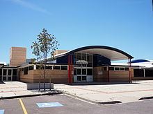
Government schools
Non-government schools
Churches
St Mary in the Valley Anglican Parish Centre is located on the corner of Were Street and Webber Crescent; in addition to Church services the Parish also manages the Calwell Community Centre. Alliance Church Tuggeranong is also located on Were Street. Corpus Christi Catholic Parish, based in Gowrie, runs services in the hall at St Francis of Assisi Primary School. The historic Sacred Heart Church was relocated to Calwell in 1988, and is used for special occasions
Transport
Calwell is serviced by several ACTION bus routes.
All Canberra taxi companies and Queanbeyan taxis also service Calwell.
Geology
Deakin Volcanics green grey and purple rhyodacite of Silurian age form the base rock of Calwell.