
 | ||
Transport in Bhutan comprises approximately 8,000 kilometres (5,000 mi) of roads and four airports, out of which 3 are operational and interconnected. Paro Airport is the only airport that serves international flights. As part of Bhutan's infrastructure and modernization programs, its road system has been under development since the 1960s.
Contents
There are no railways, although one is planned, and as Bhutan is a landlocked country without major waterways, no ports.
History
Until 1961, because of the lack of paved roads, travel in Bhutan was by foot or on muleback or horseback. The 205-kilometre (127 mi) trek from the Indian border to Thimphu took six days. Modern road construction began in earnest during the First Development Plan (1961–66). The first 175-kilometre-long (109 mi) paved road was completed in 1962 (a branch road later linked Paro with the Phuntsholing–Thimphu road). Described as a jeep track, it linked Thimphu and Phuntsholing with Jaigaon, West Bengal. The travel time by motor vehicle from the border to Thimphu had shrunk to six hours. Some 30,000 Indian and Nepalese labourers were imported to build the road with Indian aid at a time when India was bolstering its strategic defence against a possible Chinese invasion. Bhutan also provided labour for the construction work. Another road was also built to connect Tashigang with Tawang, Arunachal Pradesh.
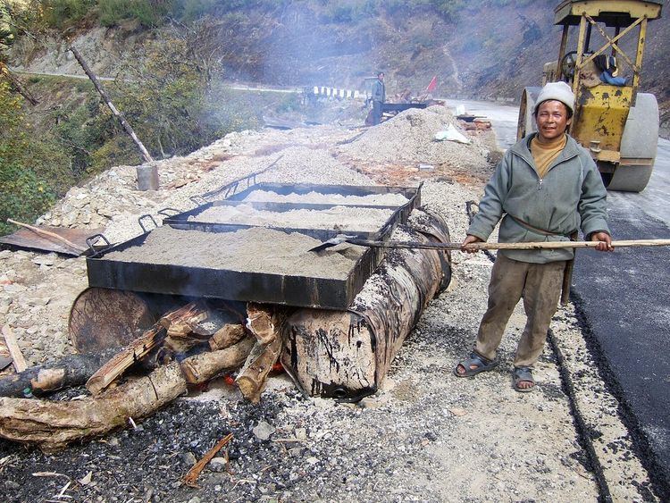
By the mid 1970s, about 1,500 kilometres (930 mi) of roads had been built, largely by manual labor. There was a linked network of 2,280 kilometres (1,420 mi) of roads in 1989; at least 1,761 kilometres (1,094 mi) of these were paved with asphalt, and 1,393 kilometres (866 mi) were classified as national highways. Despite the construction of surfaced roads linking the principal towns in the south, the mountainous terrain elsewhere makes travel even from one valley to the next quite difficult. Most roads run in river valleys. As part of the Sixth Development Plan, the Department of Public Works, in cooperation with the Indian Border Roads Organization, made plans to construct and upgrade 1,000 kilometres (620 mi) of roads and to extend the road network through the five major river valleys by 1992. Motorable roads were not the only important development. It was estimated as part of the Fifth Development Plan that Bhutan also needed some 2,500 kilometres (1,600 mi) of mule tracks to connect the nation's 4,500 settlements.
Roadways
The country's primary road is the East-West highway, known locally as the Lateral Road, which was constructed starting in 1962. The road starts in Phuentsholing on the southwestern Indian border and terminates in Trashigang in the far east, with spurs to other main centres such as Paro, Thimphu, and Punakha. The Lateral Road is built to a standard width of only 2.5 metres (8.2 ft) yet must support traffic in both directions (the cost of cutting a wider road through the mountainous Middle Himalayas is prohibitive at this time). Safety barriers, road markings, and signage are sparse. Traffic proceeds at a slow speed, typically around 15 km/h (9.3 mph), to minimise head-on collisions. Road accidents still occur frequently and, because of the steep mountainous topography, are typically horrific. Most of the route between Paro Airport and Thimphu has recently been improved to a two lane road.
The Lateral Road traverses are a number of high passes, including Tremo La and Do Chu La. The highest pass on the road is at Chapcha; the second-highest pass is at Trumshing La in central Bhutan at an altitude of over 3,800 m (12,500 ft).
Main roadways in western and eastern Bhutan are maintained by Dantak, a unit of Border Roads Organisation engineering division of Indian Army and in the rest of the country by the Bhutanese government's Department of Roads.
Because much of the geology is unstable, there are frequent slips and landslides, which are aggravated by both summer monsoon and winter snowstorm and frost heave conditions. Teams of Indian labourers are housed at work camps in the mountain passes to be dispatched to clear the roads in the event of road blockage. The conditions in the work camps are poor, with the workers reduced to breaking rock into gravel on a piece-rate basis when not clearing the roads. An international aid project is under way to stabilise the worst sections of the road. A major Japanese aid project seeks to replace most of the narrow single track bridges with two-way girder spans capable of carrying heavier traffic.
Most freight is moved on eight-ton 300 hp (224 kW) Tata trucks, which are often overloaded. There is a network of passenger buses, and the most common vehicle in government and private use is the four-wheel-drive pickup.
A national driver licensing system includes a driving test, but this is not rigorous. Government drivers are trained at the Samthang Vocational Training Institute driving school (formerly the National Driving Training Institute) or they learn on the job as 'handy boys'.
The roads have traffic lights; a stoplight installed in Thimphu has been dismantled, and there are recent reports of plans to reinstate it.
Airports
Bhutan currently has 4 airports:
- Paro Airport – the only international airport in Bhutan
- Bathpalathang Airport
- Gelephu Airport – not operational as of January 2014
- Yongphulla Airport – closed until 2015
Paro Airport is the country's only international airport and is located in a steep-sided valley with approaches restricted to visual flight rules. During the monsoon season, flights are often delayed by cloud cover. Drukair is the national carrier, connecting Paro to other countries.
Bathpalathang Airport and Yongphulla Airport are two domestic airports in Bhutan. The Royal Bhutanese Government's 10th Five Year Plan (which covers 2008–2013) included the building of one more domestic airport at Gelephu in Sarpang District.
There was a project for a second international airport, which was planned for construction at the Gelephu site. This was downgraded to a domestic airport project in October 2008. The Bhutanese Department of Civil Aviation indicated in January 2010, that the domestic airport at Gelephu may have provisions to be expanded into an 'all weather' airport, capable of receiving international traffic in the future. Construction was due to start in late 2010, with the airport due to start operations in June 2011. Despite being inaugurated in October 2012, Gelephu Airport has not yet established scheduled operations due to its lack of certification from the Department of Civil Aviation.
Railway
As of 2012, Bhutan had no railways.
On 25 January 2005, the King of Bhutan and Indian Prime Minister agreed to carry out a feasibility study for rail links. Possible routes were Hasimara–Phuentsholing with a branch to Pasaka (18 km); Kokrajhar–Gelephu (70 km); Pathsala–Naglam (40 km); Rangla–Darranga–Samdrupjongkar (60 km); and Banarhat–Samtse.
In December 2009, the King of Bhutan approved the final plan to build a 11-mile (18 km) long 1,676 mm (5 ft 6 in) Indian broad gauge rail link between Hashimara in West Bengal and Toribari in Bhutan. The construction of the railway via through Satali, Bharna Bari and Dalsingpara by Indian railways is being fully funded and owned by Indian Railway.