
Population 2,383 (2005) Number of airports 1 | Local time Wednesday 1:32 AM | |
 | ||
Weather 15°C, Wind NE at 2 km/h, 91% Humidity | ||
Lingkhar lodge lengkhar trashigang bhutan
Trashigang (Dzongkha: བཀྲ་ཤིས་སྒང་།), or Tashigang, is a town in eastern Bhutan and the district capital of the Trashigang Dzongkhag (district).
Contents
- Lingkhar lodge lengkhar trashigang bhutan
- Map of Trashigang Bhutan
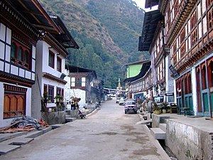
- Trashigang town in the eastern part of bhutan
- References
Map of Trashigang, Bhutan
The town lies on the east side of the valley above the Drangme Chhu River just south of where it is joined by the Gamri River. Trashigang is the eastern terminus of the Lateral Road, Bhutan's main highway leading to Phuntsholing in the southwest.
The population of Trashigang was 2,383 in according to the 2005 census.
In October 2011, Trashigang Dzong, under renovation since 2007, was on the verge of collapse. The dzong was built in 1659 by Trongsa Penlop Minjur Tenpa and served for centuries as an administrative headquarters and monastery, though government offices mostly relocated by 2011. Its sinking eastern foundation and crumbling upper walls necessitated either relocation or total destruction and reconstruction, according to dzong officials. However, as of 2012, the Trashigang Dzong was still used for the town's yearly tsechu.
Trashigang is the largest district in Bhutan. it has two sub-districts and fifteen gewogs. Sherubtse College was the first accredited college in Bhutan, founded in 1966 by a group of Jesuits under the leadership of William Mackey. As of 2003 it became part of the newly created Royal University of Bhutan system that comprises all public post-secondary schools in Bhutan.
Trashigang is served by Yongphulla Airport.