
 | ||
As the tenth-largest country in the world, and the largest in Africa and in the Mediterranean region. Algeria has a vast transportation system which include many transportation infrastructures.
Contents
Railways
There are a total of 3,973 km (2,469 mi) of railways: 2,888 km (1,795 mi) is 1,435 mm (4 ft 8 1⁄2 in) standard gauge, with 283 km (176 mi) of that being electrified and 215 km (134 mi) of that being double tracked. There are also a total of 1,085 km (674 mi) of 1,055 mm (3 ft 5 1⁄2 in) gauge track.
SNTF operates the railways, whilst a new, separate organisation, Anesrif, has been created to manage infrastructure investment.
The High Plateau line is a major new project to build an east-west line across the country, parallel to the Rocade Nord.
2009
2006
Tramways
Currently Algiers, Oran and Constantine are the only cities in the country with a tram line in operation. Tram projects have been launched in both Setif and Batna in the east, Mostaganem and Sidi Bel-Abbes in the west, and Ouargla in the South. The government, wanting to diversify the country's future in rail transport, has assigned the Algeirs Subway Company to the projects.
Highways
There are 71,656 kilometers of paved roads including 1394 kilometers of expressways and 32,344 kilometers of unpaved roads for a total road system of 104,000 kilometers.
Regional highways
Algeria has two routes in the Trans-African Highway network, including the Trans-Sahara Highway, soon to be complete as a paved road running from north to south through the country. The country has also embarked (as of 2006) in the construction of a new East-West highway.
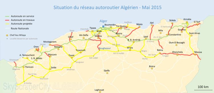
Motorways
Motorway network in Algeria is expanding increasingly, along with other kinds of infrastructure, though this is only true for the Northern region of the country, where most of its population lives. And this infrastructure is pretty well developed for North African standards.
Pipelines
There are 456 kilometers of crude oil pipeline, 298 kilometers of refined petroleum pipeline, and 2,948 kilometers of natural gas pipeline. There are also 4 gas exportation pipelines, two existing ones to Spain (Maghreb-Europe Gas Pipeline) and Italy (Trans-Mediterranean Pipeline) and 2 under construction, Medgaz between Oran and Almería, Spain and GALSI between Annaba and Sardinia, Italy. Both pipelines will be extended to France and Germany.
Mediterranean Sea
Airports
An extensive air service used an estimated 137 airports and airstrips in 2004. As of 2005, a total of 52 had paved runways, and there was one heliport. The main international airport, Houari Boumedienne Airport, is about 20 km (12 mi) from Algiers. Constantine, Annaba, Tilimsen, and Oran have smaller modern airports that can accommodate jet aircraft. Air Algérie, the national airline, provides international service. In 2003, a total of about 3.293 million passengers were carried on domestic and international flights.