
Realm Palearctic | Area 200,465 km² | |
 | ||
Climate type Subarctic, dry winters (Koppen Dwc) | ||
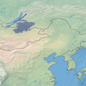
The Trans-Baikal conifer forests ecoregion (WWF ID:PA0609) covers a 1,000 km by 1,000 km region of mountainous southern taiga stretching east and south from the shores of Lake Baikal in the Southern Siberia region of Russia, and including part of northern Mongolia. Historically, the area has been called "Dauria", or Transbaikal ("the land beyond Lake Baikal"). It is in the Palearctic ecozone (WWF System Biome), and mostly in the Boreal forests/taiga ecoregion with a subarctic, humid climate. It covers 200,465 km2 (77,400 sq mi).
Contents
Location and description
The ecoregion is centered on the Yablonoi Mountains, a range that reaches heights of 1,600 metres (5,200 ft), and runs southwest to northeast, parallel to Lake Baikal. The western edge of the region is the eastern shore of Lake Baikal and the Barguzin mountain range. The city of Chita is at the northeast of the region, and the city of Ulaanbaatar, Mongolia, is just outside the southern point of the region. To the south are the Khentii Mountains in Mongolia. To the east are the temperate grasslands of the Daurian steppe ecorgion. To the north is the Vitim tableland.
The parallel ridges of the mountains in the region form the continental divide between rivers flowing to the Arctic Ocean (by way of Lake Baikal and the Lena River), and the Pacific Ocean (by way of the Amur River).
Climate
The climate of the ecoregion is Subarctic climate, dry winters ((Dwc)). This climate is characterized by long, very cold winters, and cool summers. but with little snow in winters. The Siberian High (also called the Siberian Anticyclone) keeps the area particularly dry in the winters. During the summer, the Inner Asiatic Depression brings hot air from the deserts of China and Mongolia, raising the temperature in the Transaikal. To the north of the region, the climate grades into Humid continental climate, cool summer (Dfc), with cooler summers. To the south of the ecoregion in Mongolia, the climate is grades into Cold semi-arid climate (Koppen BSk), with less precipitation than the Transbaikal. Precipitation in the Transbaikal ranges from 400–500 mm/year in the uplands, to 200 mm/year in the lower and more southerly areas.
Flora
The region is mostly forested below the 1,400 meter level. The characteristic trees on the warmer, wetter west side of the Yablonovsky Ridge are Dahurian larch (Larix gemilii)) and Siberian pine (Pinus sibirica). On the warmer and drier east of the ridge the larch is mixed with Scots pine (Pinus sylvestris). The trees are draped with moss and lichen.
The flora of the Transbaikal exhibits altitude zoning. At the lowest levels in the river valleys and lowlands (0–600 meters), the characteristic vegetation is that of the steppes: bunchgrass (Stipa capillata), fescue, junegrass (Koeleria gracilis), and Filifolium (Tanacetum sibiricum). The next level (600-1,100 meters) is a forest-steppe level, and from 1,100–1800 meters a forest level featuring Larix gemilii and Pinus sylvestris. Above 1,800 meters is shrub land of Siberian dwarf pine (Pinus pumila, dwarf birch (Betula exilis), and Juniperus pseudosibirica. Unlike the Sayan and Altai mountains to the west, the climate of the Transbaikal is too extreme to support alpine meadows; the vegetation proceeds from forest directly to higher-altitude shrubs.
Fauna
The extensive tree cover provides good habitat for deer, bighorn sheep, bear, wild boar, and other large mammals.
Freshwater ecosystems
The Transbaikal terrestrial ecoregion covers the "Lake Baikal" Freshwater Ecoregion (WWF ID:606). This freshwater ecoregion supports a "large lakes" habitat for aquatic life, the primary focus of scientific study being on Lake Baikal itself and fish that spawn in the rivers that feed into it (such as the Barguzin River in the Transbaikal).
Protections
The Lake Baikal area on the western edge of the ecoregion is a UNESCO Man and Biosphere (MAB) Biosphere Reserve. It is also a UNESCO World Heritage Site
Three large protected areas of the Russian Federation in the Transbaikal ecoregion are:
Two large protected areas of the Transbaikal are in Mongolia:
Threats
Forest fires are always a threat to wooded, dry areas; drought in recent years has increased the threat of wildfire. The area also suffers from pest outbreaks and uncontrolled logging. There is also gold mining in the area, and is a threat to the streams and bogs.
Urban areas and settlements
The major cities of the ecoregion are Ulan-Ude and Petrovsk-Zaybaykalsky in Republic of Buryatia, and Chita and Khilok in Zabaykalsky Krai. Otherwise, the region is sparsely populated. The Trans-Siberian Railroad bisects the region from west to east.