
Population 2,910 (1992) Founded 1861 | Established 1861 Area 25.92 km² Council seat Saint Arnaud | |
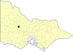 | ||
The Town of St. Arnaud was a local government area about 240 kilometres (149 mi) northwest of Melbourne, the state capital of Victoria, Australia. The town covered an area of 25.92 square kilometres (10.0 sq mi), and existed from 1861 until 1994. Its area was surrounded by the Shire of Kara Kara.
Contents
History
St. Arnaud was first incorporated as a municipal district on 16 August 1861. It became a borough on 1 October 1863, and a town on 17 October 1950.
On 20 January 1995, the Town was abolished, and merged with City of Stawell, most of the Shires of Stawell and Kara Kara, the Grampians National Park within the Shire of Wimmera and parts of the Shires of Ararat, Avoca, Donald and Dunmunkle into the Shire of Northern Grampians.
The Town of St Arnaud was not subdivided into wards, and the nine councillors represented the entire area.
Population
* Estimate in the 1958 Victorian Year Book.