
Easiest route South-east Ridge (PD) First ascent 22 July 1876 | Elevation 3,792 m | |
 | ||
Similar Mont Blanc du Tacul, Dent du Géant, Mont Maudit, Grand Capucin, Aiguille Verte | ||
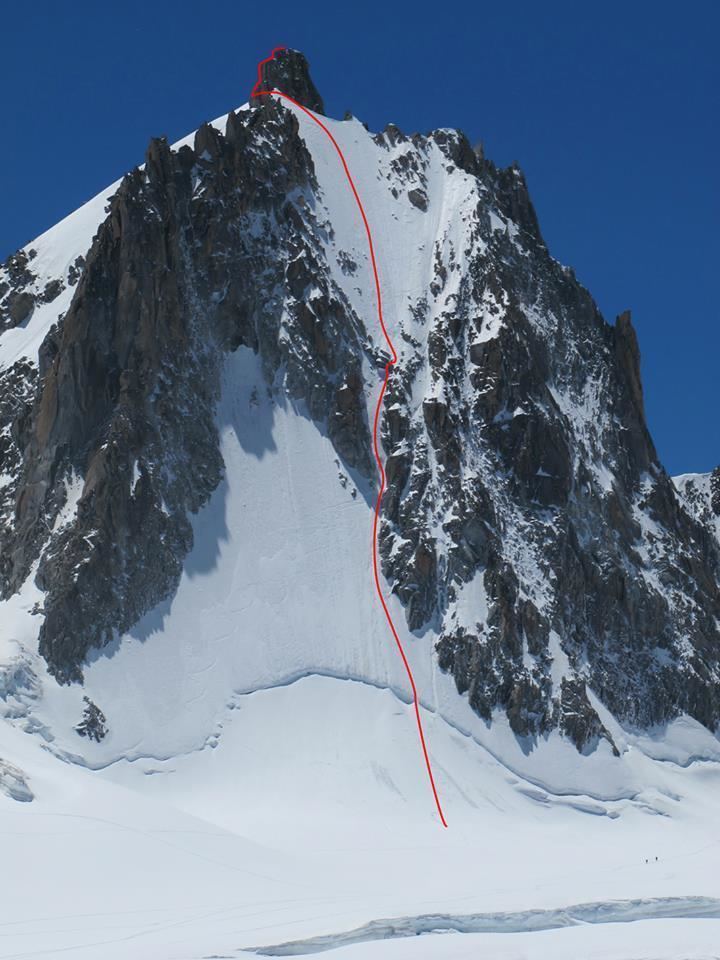
Voie normale de la tour ronde chamonix mont blanc alpinisme 9123
The Tour Ronde (3,792 m) is a mountain in the Mont Blanc massif of the Alps, situated on the border between France and Italy. It is a prominent mountain, some 3.5 km north-east of Mont Blanc, but is effectively part of a continuation of the south eastern spur of Mont Maudit (l'Arete de la Brenva) which forms a frontier ridge between the two countries. It is easily accessible to mountaineers and provides not only a very good viewpoint from its summit of the Brenva face and the major peaks on the southern side of Mont Blanc, but it also offers a popular introduction to alpine climbing of all grades, including a north face ascent.
Contents
- Voie normale de la tour ronde chamonix mont blanc alpinisme 9123
- Map of La Tour Ronde 74400 Chamonix France
- Tour ronde voie r buffat chamonix mont blanc alpinisme 7705
- First Ascents
- Viewpoint
- Access
- Routes
- Events and incidents
- Climate change permafrost and rockfall
- References
Map of La Tour Ronde, 74400 Chamonix, France
Tour ronde voie r buffat chamonix mont blanc alpinisme 7705
First Ascents
Viewpoint
The relatively isolated but easily accessible summit of the Tour Ronde has a reputation for providing mountaineers with one of the finest viewpoints within the Mont Blanc range, and offers an ideal place for observing the sun rising on Mont Blanc itself. To the north it offers extensive views over the wide and heavily crevassed Glacier du Géant and the Vallée Blanche towards the Aiguille du Midi, whilst looking westwards it provides very extensive views towards Mont Maudit and the full sweep of the Brenva Face of Mont Blanc and the Peuterey Ridge.
Writing about the first ascensionist's impression of the view from the summit of the Tour Ronde, one author quoted Douglas Freshfield in volume 6 of The Alpine Journal (1874), thus:
He wrote of this at the time that no other view had left upon his mind "a recollection of such overpowering magnificence".
Access
The Tour Ronde can be most easily reached within about 1.5 hours from the Torino Hut near Pointe Helbronner, where mountaineers spend the night before leaving, usually well before dawn, to ascend the summit early the next day. Alternate and longer routes can be made from the Refuge des Cosmiques at the Col du Midi via a passage across the head of the Vallee Blanche and the Glacier du Geant (or from Chamonix via the Aiguille du Midi and the Vallée Blanche Aerial Tramway). Pointe Helbronner can also be reached from the Italian side on foot or via cablecar from Courmayeur. Other even longer start or finish points include the Requin Hut above Montenvers, reached by a long but impressive glacier trek.
Routes
The mountain provides many routes of ascent, and of varying difficulty and danger, as well as opportunities for possible new routes of mixed climbing. Classic mountaineering routes on the Tour Ronde include:
Other new mixed climbing ascents routes have also been achieved in recent years although, because of the mountain's popularity and accessibility, it can be difficult to determine whether the routes are actually new or not.
Events and incidents
Climate change, permafrost and rockfall
In 2005 the Tour Ronde became the first high mountain ever to be subject to extremely detailed laser-scanning and monitoring. Amid growing concern in recent decades that climate change had been increasing the incidence of severe rock-fall and loss of permafrost at high altitude, a study was launched to monitor potentially unstable rock faces and to assess changes over time. Previous techniques had used aerial photography and digital elevation modelling (DEM), but were deemed not to be sufficiently accurate to monitor change because of the vertical viewpoint and shadowing effects, plus the general coarse nature of their results.
By 2005 the newly-evolving technique of Light Detection and Ranging, known as LiDAR, permitted highly detailed laser scanning of high mountain rock faces, measuring many thousands of separate points every second, and from a distance of up to 800 metres. An EU Interreg–funded project was established to undertake research. Known as PERMAdataROC, its aims were to "improve our understanding of the relationship between permafrost degradation and slope instabilities by quantifying the occurrence and magnitude of rock falls from high-mountain rock walls". Seven sites in the Mont Blanc Massif were selected, with the east face of the Tour Ronde being the first to be analysed. Measurements were taken in July 2005 and again in July 2006.
An area of the east face of 67,400 m² was laser-scanned, creating 22 overlapping computer images, with measurements accurate to between 3 and 5 cm. Careful computer analysis revealed that in the twelve-month period between scans, the measured area had lost 536 m³ of rock. This is comparable to an erosion rate across the entire measured area of the face of 8.4 mm per year – a figure significantly greater than those found in rock walls of high-altitude permafrost in Switzerland and Greenland. The project concluded that the higher rock fall rate exhibited on the Tour Ronde and elsewhere in the Mont Blanc massif was linked to the degradation in permafrost which would have held the mountain together more effectively, but which now exposed it to greater weathering through the freeze-thaw cycle of water, with maximum occurrence during warm summers.
In 2015 a huge rockfall on the Tour Ronde's east face was captured on film by climbers, demonstrating that instability in this mountain area remains at a significant level.