
Elevation 4,465 m First ascent 12 September 1878 | Prominence 162 m Parent range Graian Alps | |
 | ||
Easiest route North-east approach to north-west ridge (PD) Similar Mont Blanc du Tacul, Dôme du Goûter, Dent du Géant, Aiguille du Midi, Aiguille Verte | ||
Kuffner ridge mont maudit 20 7 2016
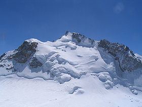
Mont Maudit (4,465 m) is a mountain in the Mont Blanc massif in France and Italy. The French name literally means "Cursed Mountain". Until the end of the 18th century, Mont Blanc and its satellite peaks were collectively known in French as the Montagne Maudite.
Contents
Map of Mont Maudit
Climbing history
The first ascent of Mont Maudit was by a British party comprising Henry Seymour King and the lawyer/diplomat William Edward Davidson with guides Johann Jaun and Johann von Bergen on 12 September 1878. The route they took was via the south ridge, during an ascent of Mont Blanc by the Corridor route.
The southern side of the mountain is considerably steeper than the gentle snow slopes of the northern side and features the well-known southeast or Frontier ridge (also known as the Kuffner ridge, D). This route was first climbed by Moriz von Kuffner with guides Alexander Burgener and Josef Furrer from 2–4 July 1887. George Mallory, in a party led by R. L. G. Irving, made the third ascent of the route in 1911. Ascents of the ridge start from the hut on the Col du Trident and take at least seven to eight hours.
2012 avalanche
On 12 July 2012, at least nine climbers—three from the United Kingdom (including Roger Payne, a mountain guide and former general secretary of the British Mountaineering Council), two from Switzerland, two from Germany, and two from Spain—were killed by an avalanche as they attempted a dawn ascent of the mountain from the Refuge des Cosmiques. Nine others were injured and flown to hospital. The avalanche struck at 5 am, as the climbers began their climb up one of the most popular, but dangerous, routes up the mountain. Éric Fournier, the mayor of Chamonix–Mont Blanc, described the snowslide as one of the deadliest in recent years. "There was no weather bulletin giving any avalanche warning," he claimed.